From Surf Wiki (app.surf) — the open knowledge base
Dorrance Township, Pennsylvania
Township in Pennsylvania, US
Township in Pennsylvania, US
| Field | Value |
|---|---|
| official_name | Dorrance Township, Pennsylvania |
| settlement_type | Township |
| image_skyline | Field in Dorrance Township, Luzerne County, Pennsylvania.JPG |
| image_caption | Field in Dorrance Township on Saint Marys Road |
| image_map | Map of Luzerne County, Pennsylvania Highlighting Dorrance Township.PNG |
| mapsize | 250x200px |
| map_caption | Map of Luzerne County highlighting Dorrance Township |
| image_map1 | Map of Pennsylvania highlighting Luzerne County.svg |
| mapsize1 | 250x200px |
| map_caption1 | Map of Pennsylvania highlighting Luzerne County |
| subdivision_type | Country |
| subdivision_name | United States |
| subdivision_type1 | State |
| subdivision_name1 | Pennsylvania |
| subdivision_type2 | County |
| subdivision_name2 | Luzerne |
| established_title | Settled |
| established_title1 | Incorporated |
| unit_pref | Imperial |
| area_footnotes | |
| area_total_km2 | 63.11 |
| area_land_km2 | 62.67 |
| area_water_km2 | 0.43 |
| area_total_sq_mi | 24.37 |
| area_land_sq_mi | 24.20 |
| area_water_sq_mi | 0.17 |
| population_as_of | [2020](2020-united-states-census) |
| population_footnotes | |
| population_total | 2077 |
| population_density_km2 | 35.33 |
| population_density_sq_mi | 91.50 |
| timezone | Eastern (EST) |
| utc_offset | -5 |
| timezone_DST | EDT |
| utc_offset_DST | -4 |
| website | |
| pop_est_as_of | 2021 |
| pop_est_footnotes | |
| population_est | 2072 |
| blank_name | FIPS code |
| blank_info | 42-079-19616 |
Dorrance Township is a township in Luzerne County, Pennsylvania, United States. The population was 2,077 at the 2020 census.
History
Founding
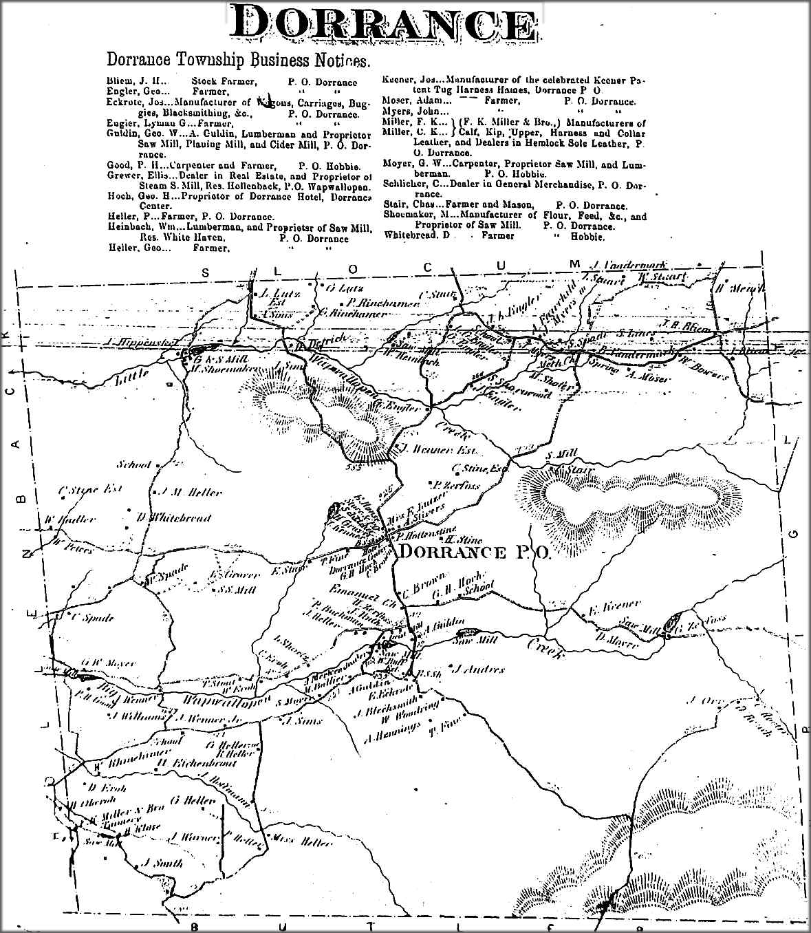
It's believed that the township's first white settlers were hunters and fishermen. They were soon followed by lumberjacks. The community bears the name of Col. George Dorrance, who was killed in the Battle of Wyoming on July 3, 1778. Following the battle, settlers began to move into what is now Dorrance Township.
The township was officially formed in 1840, when it broke away from Newport Township. By 1860, over five hundred people lived within the township. In 1865, the community had several sawmills, gristmills, and at least one tavern.
Dorrance Village is the only hamlet in the township; it is located near the center of the community. It became a major intersection in the township. A schoolhouse, which also acted as a meeting house, was constructed near the crossroads.
Geography
According to the United States Census Bureau, the township has a total area of 63.1 km2, of which 62.7 km2 is land and 0.4 km2, or 0.68%, is water. Dorrance Township is part of the Mountain Top region of Luzerne County. The township, which consists mostly of farmland and forests, is located within a valley (between Penobscot Mountain—to the north—and Nescopeck Mountain—to the south). Several lakes and streams (e.g., Little Wapwallopen Creek and Big Wapwallopen Creek) are scattered throughout the township. Dorrance Village is the only hamlet in the township; it is centrally located. I-81 and PA 309 run through the eastern section of Dorrance Township.
Demographics
As of the census of 2000, there were 2,109 people, 775 households, and 626 families residing in the township. The population density was 87.4 PD/sqmi. There were 816 housing units at an average density of 33.8 /sqmi. The racial makeup of the township was 99.24% White, 0.05% African American, 0.09% Asian, and 0.62% from two or more races. Hispanic or Latino of any race were 0.28% of the population.
There were 775 households, out of which 37.7% had children under the age of 18 living with them, 69.5% were married couples living together, 8.8% had a female householder with no husband present, and 19.1% were non-families. 17.0% of all households were made up of individuals, and 6.6% had someone living alone who was 65 years of age or older. The average household size was 2.72 and the average family size was 3.05.
In the township the population was spread out, with 25.9% under the age of 18, 6.3% from 18 to 24, 29.8% from 25 to 44, 26.0% from 45 to 64, and 12.0% who were 65 years of age or older. The median age was 38 years. For every 100 females, there were 101.0 males. For every 100 females age 18 and over, there were 96.2 males.
The median income for a household in the township was $44,545, and the median income for a family was $49,583. Males had a median income of $34,194 versus $26,364 for females. The per capita income for the township was $19,519. About 2.4% of families and 3.4% of the population were below the poverty line, including 4.0% of those under age 18 and 4.4% of those age 65 or over.
Education
Dorrance Township is part of Crestwood School District.
References
References
- "2016 U.S. Gazetteer Files". United States Census Bureau.
- "City and Town Population Totals: 2020—2021". US Census Bureau.
- "DORRANCE TOWNSHIP".
- Gannett, Henry. (1905). "The Origin of Certain Place Names in the United States". Govt. Print. Off..
- "Census of Population and Housing". Census.gov.
- "U.S. Census website". [[United States Census Bureau]].
This article was imported from Wikipedia and is available under the Creative Commons Attribution-ShareAlike 4.0 License. Content has been adapted to SurfDoc format. Original contributors can be found on the article history page.
Ask Mako anything about Dorrance Township, Pennsylvania — get instant answers, deeper analysis, and related topics.
Research with MakoFree with your Surf account
Create a free account to save articles, ask Mako questions, and organize your research.
Sign up freeThis content may have been generated or modified by AI. CloudSurf Software LLC is not responsible for the accuracy, completeness, or reliability of AI-generated content. Always verify important information from primary sources.
Report