From Surf Wiki (app.surf) — the open knowledge base
Copper River (Alaska)
River in Alaska, United States
River in Alaska, United States
| Field | Value |
|---|---|
| name | Copper River |
| image | Chitina dipnet.jpg |
| image_size | |
| image_caption | A fisherman (*bottom center*) dipnetting for salmon on the Copper River at Chitina in Southcentral Alaska |
| source1_location | Copper Glacier on Mount Wrangell |
| source1_coordinates | |
| tributary_left | Sanford River |
| tributary_left1 | Klawasi River |
| tributary_left2 | Nadina River |
| tributary_left3 | Dadina River |
| tributary_left4 | Chetaslina River |
| tributary_left5 | Cheshnina River |
| tributary_left6 | Kotsina River |
| tributary_left7 | Chitina River |
| tributary_left8 | Bremner River |
| tributary_left9 | Wernicke River |
| tributary_left10 | Martin River |
| tributary_right | Slana River |
| tributary_right1 | Chistochina River |
| tributary_right2 | Gakona River |
| tributary_right3 | Gulkana River |
| tributary_right4 | Tazlina River |
| tributary_right5 | Klutina River |
| tributary_right6 | Tonsina River |
| tributary_right7 | Uranatina River |
| tributary_right8 | Tiekel River |
| tributary_right9 | Tasnuna River |
| tributary_right10 | Heney River |
| tributary_right11 | Allen River |
| tributary_right12 | Goodwin River |
| mouth_location | Copper Bay of Pacific Ocean |
| mouth_coordinates | |
| subdivision_type1 | Country |
| subdivision_name1 | United States |
| subdivision_type2 | State |
| subdivision_name2 | Alaska |
| length_mi | 290 |
| source1_elevation | 4380 ft |
| mouth_elevation | 0 ft |
| discharge1_avg | 57400 cuft/s at mouth |
| basin_size_mi2 | 24000 |
--
The Copper River or Ahtna River (; , "river of the Ahtnas"; ), "river of copper", is a 290-mile (470 km) river in south-central Alaska in the United States. It drains a large region of the Wrangell Mountains and Chugach Mountains into the Gulf of Alaska. It is known for its extensive delta ecosystem, as well as for its prolific runs of wild salmon, which are among the most highly prized stocks in the world. The river is the tenth largest in the United States, as ranked by average discharge volume at its mouth.{{cite web
Description
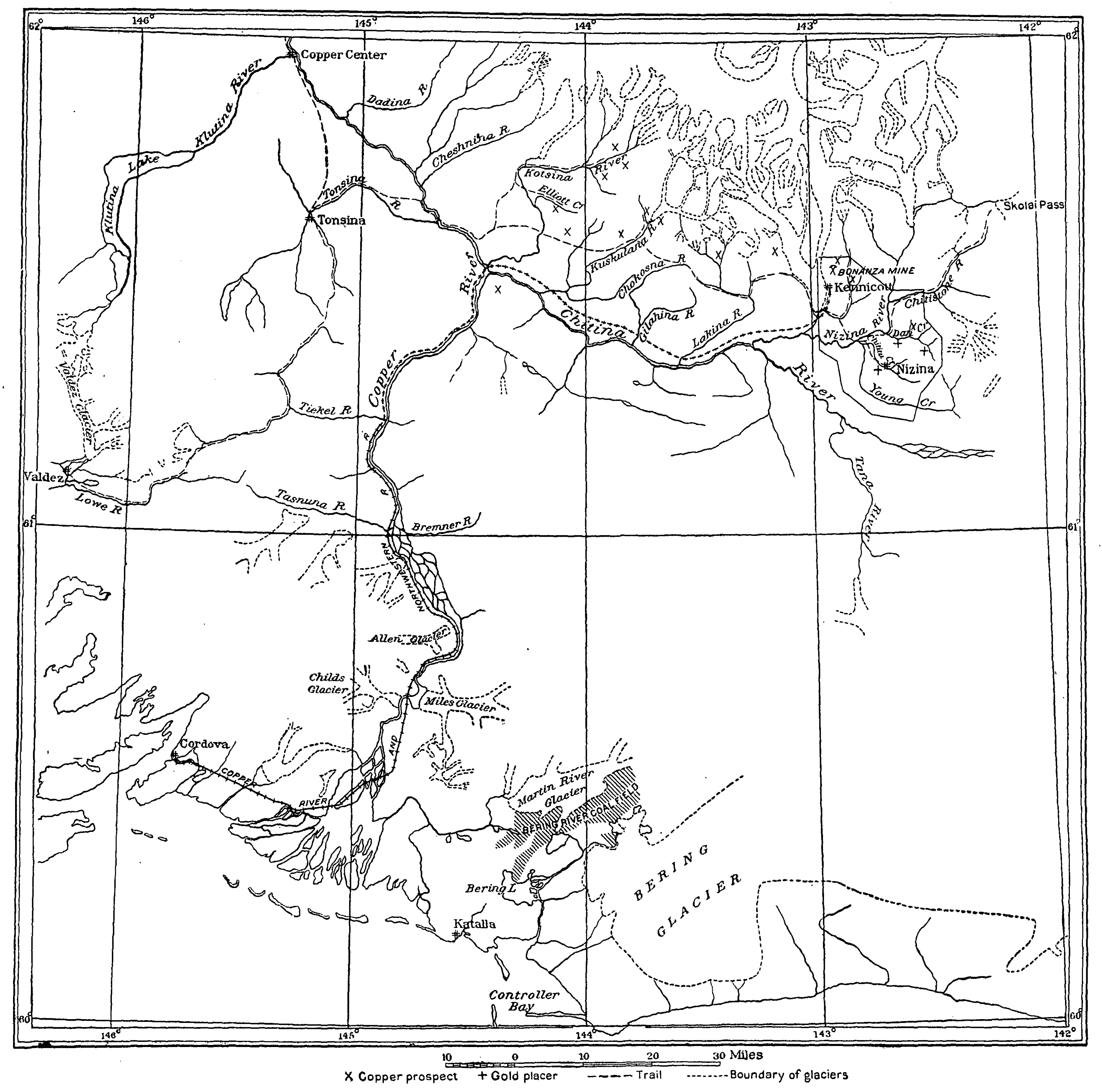
The Copper River rises out of the Copper Glacier, which lies on the northeast side of Mount Wrangell, in the Wrangell Mountains, within Wrangell-Saint Elias National Park. It begins by flowing almost due north in a valley that lies on the east side of Mount Sanford, and then turns west, forming the northwest edge of the Wrangell Mountains and separating them from the Mentasta Mountains to the northeast. It continues to turn southeast, through a wide marshy plain to Chitina, where it is joined from the southeast by the Chitina River (Ahtna Athabascan Tsedi Na'
The Copper River is approximately 290 mi long. It drops an average of about 12 ft/mi, and drains more than 24000 sqmi—an area the size of West Virginia. The river runs at an average of 7 mph.
Downstream from its confluence with the Chitina it flows southwest, passing through a narrow glacier-lined gap in the Chugach Mountains within the Chugach National Forest east of Cordova Peak. There is an extensive area of linear sand dunes up to 250 ft in height radiating from the mouth of the Copper River. Both Miles Glacier and Childs Glacier calve directly into the river. The Copper enters the Gulf of Alaska southeast of Cordova where it creates a delta nearly 50 miles wide.
History
The name of the river comes from the abundant copper deposits along the upper river that were used by Alaska Native population and then later by settlers from the Russian Empire and the United States. The construction of the Copper River and Northwestern Railway from Cordova through the upper river valley from 1908 to 1911 allowed widespread extraction of the mineral resources, in particular from the Kennecott Mine, discovered in 1898. The mine was abandoned in 1938 and is now a ghost town tourist attraction and historic district maintained by the National Park Service.
Copper River Highway (Alaska Route 10) runs from Cordova to the lower Copper River near Childs Glacier, following the old railroad route and ending at the reconstructed Million Dollar Bridge across the river. The Tok Cut-Off (Alaska Route 1) follows the Copper River Valley on the north side of the Chugach Mountains.
Fisheries

The river's famous salmon runs arise from the use of the river watershed by over 2 million salmon each year for spawning. The river's commercial salmon season is very brief, beginning in May for chinook salmon, and sockeye salmon for periods lasting mere hours or several days at a time. Sport fishing by contrast is open all year-long, but peak season on the Copper River lasts from August to September, when the coho salmon runs. The fisheries are co-managed by the Alaska Department of Fish and Game (ADF&G) and the Department of the Interior Federal Subsistence Board. Management data is obtained primarily by ADF&G at the Miles Lake sonar station and via the native village of Eyak at the Baird Canyon and Canyon Creek research stations.
Birding
The Copper River Delta, which extends for 700,000 acres (2,800 km2), is the largest contiguous wetlands along the Pacific coast of North America. It is also home to the world's largest population of nesting trumpeter swans and is the only known nesting site for the dusky Canada goose subspecies (Branta canadensis occidentalis).
File:Miles Glacier Bridge, damage and kludge, 1984.jpg|Miles Glacier Bridge, showing earthquake damage and temporary repair, 1984 File:Copper River Alaska with river rafters.jpg|Rafters and Child's Glacier on the lower Copper River File:Copper River fishwheels.jpg|Fishwheels on the Copper River Image:Copper2.jpg|Sand dunes on the Copper River File:Copper River near Chitina.jpg|Copper River near Chitina, looking south from the bridge Image:Picea mariana taiga.jpg|Black spruce taiga along the Copper River Image:Glacial Dust off Alaska.jpg|Wind picks up fine sediment from the riverbank and carries it over the ocean.
References
References
- (2011). "AHTNA NOUN DICTIONARY and Pronunciation Guide". The Ahtna Heritage Foundation.
- "Tlingit (Lingít, Łingít)".
- Thornton, Thomas F. (January 2012). "Being and Place Among the Tlingit, p. 64". University of Washington Press.
- (1950). "Geological Survey Circular, Issues 491-500". USGS.
- (2005). "Special Ecological Sites IN ALASKA'S EASTERN PRINCE WILLIAM SOUND & COPPER RIVER DELTA". National Wildlife Federation.
- "Frequently Asked Questions". NPS.
- (1902). "Recent Explorations in Alaska". The Geographical Journal.
- (2011). "AHTNA NOUN DICTIONARY and Pronunciation Guide". The Ahtna Heritage Foundation.
- (1997). "Geomorphology of the Lower Copper River, Alaska". USGS.
- (1905). "Geology of the Central Copper River Region, Alaska Issue 41 of Geological Survey professional paper Geology of the Central Copper River Region, Alaska". US Government Printing Office.
- "Copper River Float". NPS.
- (2006). "This Land: A Guide to Western National Forests". University of California Press.
- "Cordova Peak, Alaska".
- "Chugach Visitors Guide Summer 2014". Alaska Geographic.
- "Human History". NPS.
- Staff. "The Copper River Highway". The Milepost.
- "Overview Map of Copper River Highway".
- "Glenn Highway-Tok Cutoff".
- (22 August 2014). "corodva, alaska: copper river salmon fishing".
- "Copper River salmon opening today with first 12 hour fishing period".
- "Copper River Fish". Alaska Department of Fish and Game.
- (June 2025). "PRINCE WILLIAM SOUND FRESH WATERS".
- (2009). "Insiders' Guide® to Anchorage and Southcentral Alaska: Including the Kenai Peninsula, Prince William Sound, and Denali National Park". Rowman & Littlefield.
- "Federal Subsistence Board News Release".
- "U.S. Fish and Wildlife Service Office of Subsistence Management Fisheries Resource Monitoring Program Estimating Chinook salmon escapement on the Copper River, 2004 annual report Annual Report No. FIS 04-503". LGL Alaska Research Associates, Inc..
- "Copper River Sonar Tools". ADF&G.
- "Birdwatching at the Copper River Delta in Alaska".
- "Species at Alaganik Slough". US Forest Service.
- "Birds Field Trip: Dusky Canada Geese". Ridgefield National Wildlife Refuge Friends Association.
This article was imported from Wikipedia and is available under the Creative Commons Attribution-ShareAlike 4.0 License. Content has been adapted to SurfDoc format. Original contributors can be found on the article history page.
Ask Mako anything about Copper River (Alaska) — get instant answers, deeper analysis, and related topics.
Research with MakoFree with your Surf account
Create a free account to save articles, ask Mako questions, and organize your research.
Sign up freeThis content may have been generated or modified by AI. CloudSurf Software LLC is not responsible for the accuracy, completeness, or reliability of AI-generated content. Always verify important information from primary sources.
Report