From Surf Wiki (app.surf) — the open knowledge base
Carleton County, New Brunswick
County in New Brunswick, Canada
County in New Brunswick, Canada
| Field | Value |
|---|---|
| name | Carleton |
| settlement_type | County |
| image_map | Map of New Brunswick highlighting Carleton County.png |
| map_caption | Location within New Brunswick. |
| subdivision_type | Country |
| subdivision_name | Canada |
| subdivision_type1 | Province |
| subdivision_name1 | New Brunswick |
| seat_type | Electoral Districts |
| Federal | |
| seat | |
| Tobique—Mactaquac | |
| parts_type | Provincial |
| parts | Carleton & Victoria-Tobique |
| established_title | Established |
| established_date | 1831 |
| unit_pref | |
| area_footnotes | |
| area_land_km2 | 3309.06 |
| population_as_of | 2021 |
| population_footnotes | |
| population_total | 26,360 |
| population_density_km2 | 8.0 |
| population_blank1_title | Pop 2016-2021 |
| population_blank1 | 0.7% |
| population_blank2_title | Dwellings |
| population_blank2 | 11,865 |
| timezone | AST |
| utc_offset | -4 |
| timezone_DST | ADT |
| utc_offset_DST | -3 |
| area_code | 506 |
the county in New Brunswick
Federal Tobique—Mactaquac
Carleton County (2021 population 26,360) is located in west-central New Brunswick, Canada.
The western border is Aroostook County, Maine, the northern border is Victoria County, and the southeastern border is York County from which it was formed in 1831. The Saint John River bisects the western section of the county. The Southwest Miramichi River flows through the eastern section of the county. Potato farming is a major industry. The scenic town of Hartland is home to the longest covered bridge in the world.
Transportation
Major highways
Census subdivisions
[[List of communities in New Brunswick|Communities]]
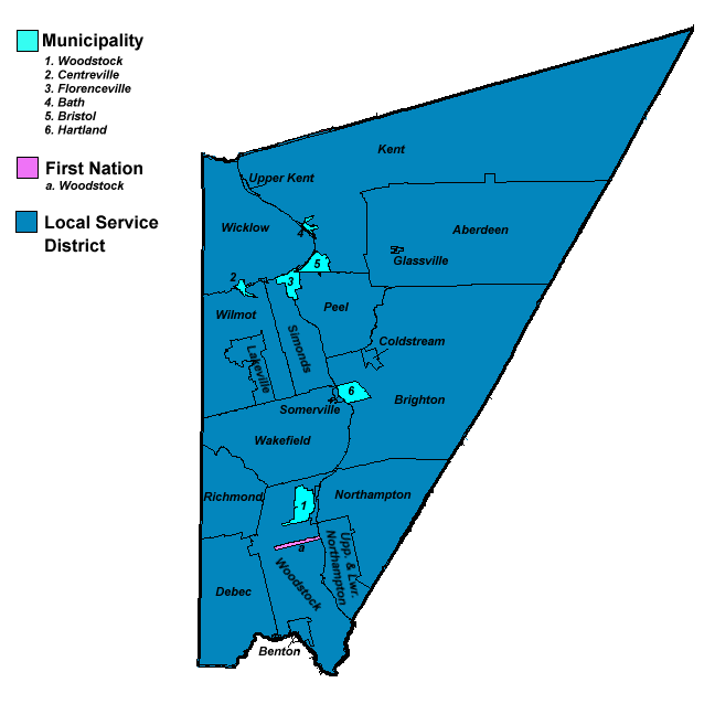
There are five incorporated municipalities within Carleton County (listed by 2021 population):
| Official name | Designation | Area km2 | Population | Parish |
|---|---|---|---|---|
| Woodstock | Town | 14.96 | 5,553 | Woodstock |
| Florenceville-Bristol | Town | 15.74 | 1,573 | Simonds |
| Hartland | Town | 9.50 | 933 | Brighton |
| Centreville | Village | 2.67 | 508 | Wicklow |
| Bath | Village | 2.00 | 440 | Kent |
First Nations
There is one First Nations reserve in Carleton County, the Woodstock First Nation:
| Official name | Designation | Area km2 | Population | Parish |
|---|---|---|---|---|
| Woodstock 23 | Reserve | 1.80 | 435 | Woodstock |
Parishes
The county is subdivided into eleven parishes (listed by 2021 population):
| Official name | Area km2 | Population | municipalities | Unincorporated communities |
|---|---|---|---|---|
| Wakefield | 196.31 | 2,722 | Belleville / Briggs Corner / Hartford / Iron Ore Hill / Jackson Falls / Jacksontown / Jacksonville / | |
| Lindsay / Lower Wakefield / Lower Waterville / McKenna / Oakville / Rosedale / Somerville / | ||||
| South Greenfield / South Wakefield / Upper Waterville / Victoria Corner / Wakefield / Waterville | ||||
| Woodstock | 194.83 | 2,219 | Woodstock (town) | |
| Woodstock 23 (reserve) | Beardsley Road / Bedell / Benton / Bulls Creek / Dibblee / Hillman / Indian Village / Mapledale / | |||
| Porten Settlement / Riceville / River Road / Speerville / Springfield / Teeds Mills / | ||||
| Townsview Estates / Upper Southampton / Upper Woodstock / Valley | ||||
| Kent | 839.76 | 1,966 | Bath (village) | Beaufort / Beechwood / Carlow / Chapmanville / Clearview / Giberson Settlement / Gordonsville / |
| Haut-Kent / Holmesville / Johnville / Kenneth / Kent / Kilfoil / Killoween / Lockharts Mill / | ||||
| Maplehurst / Monquart / Moose Mountain / Murphy Corner / Piercemont / River de Chute Siding / | ||||
| South Johnville / Summit / Tarrtown / Upper Kent / Haut-Kent / Welch | ||||
| Brighton | 509.30 | 1,596 | Hartland (town) | Armond / Ashland / Briggs Corner / Brighton / Carlisle / Cloverdale / Coldstream / East Brighton / |
| East Cloverdale / Esdraelon / Howard Brook / Jericho / Lower Brighton / Lower Windsor / | ||||
| Mainstream / Mountain View / Pole Hill / Shewan / Simonds / South Knowlesville / Windsor | ||||
| Northampton | 243.31 | 1,875 | Carr / East Newbridge / Grafton / Grafton Hill / Harten Corner / Kilmarnock / Lower Northampton / | |
| Newbridge / Newburg / Northampton / Pembroke / South Newbridge / Upper Northampton | ||||
| Wicklow | 195.50 | 1,591 | Centreville (village) | Clearview / Gregg Settlement / Hartley Settlement / Knoxford / Lamoreaux Corner / Listerville / |
| Lower Greenfield / McGrath Corner / McMonagle Corner / Middle Greenfield / Royalton / | ||||
| Summerfield / Thomas Corner / Tracey Mills / Tweedie / Upper Knoxford / Upper Royalton / | ||||
| Upper Wicklow / Wakem Corner / Wicklow | ||||
| Richmond | 258.80 | 1,456 | Blackies Landing / Blowdown / Campbell Settlement / Debec / Elmwood / Elmwood Station / | |
| Green Road / Hodgdon Road / Irish Settlement / Kirkland / Limestone / McKenzie Corner / | ||||
| Monument / Oak Mountain / Plymouth / Richmond / Richmond Corner / Union Corner / | ||||
| Watson Settlement / Wickham | ||||
| Peel | 112.74 | 1,198 | Buckwheat Brook / East Coldstream / Lansdowne / Mount Pleasant / Oakland / Peel / Riverbank / | |
| South Gordonsville / Stickney | ||||
| Wilmot | 191.40 | 969 | Avondale / Beckim Settlement / Bloomfield / Bradley Corner / Brookville / Carvell / Charleston / | |
| Deerville / Digby Corner / Good Corner / Lakeville / Long Settlement / Lower Bloomfield / | ||||
| McKeaghan / Weston / Wilmot | ||||
| Aberdeen | 444.88 | 812 | Aberdeen / Argyle / Biggar Ridge / Centre Glassville / Divide / East Glassville / East Knowlesville / | |
| Foreston / Glassville / Hayden Ridge / Hemphill Corner / Highlands / Juniper / Juniper Station / | ||||
| Ketchum Ridge / Knowlesville / MacIntosh Mill / North Ridge / South Ridge / West Glassville | ||||
| Simonds | 75.57 | 514 | Florenceville-Bristol (town) | Carleton / Connell / Flanagan Hill / Hunters Corner / Simonds / St. Thomas / Strong Corner / |
| Upper Brighton |
Demographics
As a census division in the 2021 Census of Population conducted by Statistics Canada, Carleton County had a population of living in of its total private dwellings, a change of from its 2016 population of . With a land area of 3309.06 km2, it had a population density of in 2021.
Population trend
| Census | Population | Change (%) |
|---|---|---|
| 2021 | 26,360 | 0.7% |
| 2016 | 26,220 | 3.0% |
| 2011 | 27,019 | 1.5% |
| 2006 | 26,632 | 2.0% |
| 2001 | 27,184 | 1.0% |
| 1996 | 26,910 | 3.4% |
| 1991 | 26,026 | N/A |
| 1951 | 22,269 | N/A |
Mother tongue language (2021)
| Language | Population | Pct (%) |
|---|---|---|
| English only | 24,290 | 93.33% |
| French only | 400 | 1.54% |
| Non-official languages | 1,125 | 4.32% |
| Multiple responses | 215 | 0.83% |
Protected areas and attractions
Notable people
Main article: List of people from Carleton County, New Brunswick
References
References
- "Census Profile, 2021 Census: Carleton County, New Brunswick". Statistics Canada.
- "Census Profiles, 2021 Census - Select". Statistics Canada.
- Statistics Canada: [[Canada 1951 Census. 1951]], [[Canada 1996 Census. 1996]], [[Canada 2001 Census. 2001]], [[Canada 2006 Census. 2006]], [[Canada 2011 Census. 2011]], [[Canada 2016 Census. 2016]] census
This article was imported from Wikipedia and is available under the Creative Commons Attribution-ShareAlike 4.0 License. Content has been adapted to SurfDoc format. Original contributors can be found on the article history page.
Ask Mako anything about Carleton County, New Brunswick — get instant answers, deeper analysis, and related topics.
Research with MakoFree with your Surf account
Create a free account to save articles, ask Mako questions, and organize your research.
Sign up freeThis content may have been generated or modified by AI. CloudSurf Software LLC is not responsible for the accuracy, completeness, or reliability of AI-generated content. Always verify important information from primary sources.
Report