From Surf Wiki (app.surf) — the open knowledge base
Cambria County, Pennsylvania
County in Pennsylvania, United States
County in Pennsylvania, United States
| Field | Value |
|---|---|
| county | Cambria County |
| state | Pennsylvania |
| seal | Cambria County, Pennsylvania seal.png |
| flag | Flag of Cambria County, Pennsylvania.gif |
| founded date | November 2 |
| founded year | 1807 |
| seat wl | Ebensburg |
| largest city wl | Johnstown |
| area_total_sq_mi | 694 |
| area_land_sq_mi | 688 |
| area_water_sq_mi | 5.3 |
| area percentage | 0.8% |
| census yr | 2020 |
| pop | 133472 |
| pop_est_as_of | 2024 |
| population_est | 130108 |
| pop_est_footnotes | |
| density_sq_mi | 194 |
| web | https://www.cambriacountypa.gov/ |
| ex image | Cambria County Courthouse - Ebensburg, PA.jpg |
| ex image size | 250 |
| ex image cap | Cambria County Courthouse, built in 1890-1891 |
| time zone | Eastern |
| district | 13th |
| named for | Latin name of Wales |
| footnotes |
Cambria County is a county in the Commonwealth of Pennsylvania. As of the 2020 census, the population was 133,472. Its county seat is Ebensburg. The county was created on March 26, 1804, from parts of Bedford, Huntingdon, and Somerset counties and later organized in 1807. It was named for the nation of Wales, which in Latin is known as "Cambria". The county is part of the Southwest region of the commonwealth.
Cambria County comprises the Johnstown, PA metropolitan statistical area, which is also included in the Johnstown-Somerset, PA combined statistical area.
Geography
According to the U.S. Census Bureau, the county has a total area of 694 sqmi, of which 688 sqmi is land and 5.3 sqmi (0.8%) is water. Cambria has a warm-summer humid continental climate (Dfb) and average monthly temperatures in downtown Johnstown range from 27.8 °F in January to 71.0 °F in July, while in Ebensburg they range from 23.9 °F in January to 67.7 °F in July. PRISM Climate Group, Oregon State U Cambria County is one of the 423 counties served by the Appalachian Regional Commission, and it is identified as part of "Greater Appalachia" by Colin Woodard in his book American Nations: A History of the Eleven Rival Regional Cultures of North America.
Adjacent counties
- Clearfield County (north)
- Blair County (east)
- Bedford County (southeast)
- Somerset County (south)
- Westmoreland County (southwest)
- Indiana County (west)
National protected areas
- Allegheny Portage Railroad National Historic Site (part)
- Johnstown Flood National Memorial
Major highways
Demographics
| align-fn = center
2020 census
As of the 2020 census, the county had a population of 133,472. The median age was 46.0 years. 18.8% of residents were under the age of 18 and 23.4% of residents were 65 years of age or older. For every 100 females there were 97.9 males, and for every 100 females age 18 and over there were 96.0 males.
The racial makeup of the county was 90.1% White, 4.4% Black or African American, 0.1% American Indian and Alaska Native, 0.6% Asian,
53.9% of residents lived in urban areas, while 46.1% lived in rural areas.
There were 56,370 households in the county, of which 23.9% had children under the age of 18 living in them. Of all households, 45.3% were married-couple households, 20.0% were households with a male householder and no spouse or partner present, and 28.1% were households with a female householder and no spouse or partner present. About 32.7% of all households were made up of individuals and 16.4% had someone living alone who was 65 years of age or older.
There were 64,395 housing units, of which 12.5% were vacant. Among occupied housing units, 73.9% were owner-occupied and 26.1% were renter-occupied. The homeowner vacancy rate was 1.9% and the rental vacancy rate was 10.0%.
| Race / Ethnicity (*NH = Non-Hispanic*) | title=P004: Hispanic or Latino, and Not Hispanic or Latino by Race – 2000: DEC Summary File 1 – Cambria County, Pennsylvania | url=https://data.census.gov/table/DECENNIALSF12000.P004?q=P004:+HISPANIC+OR+LATINO,+AND+NOT+HISPANIC+OR+LATINO+BY+RACE+[73]&g=050XX00US42021 | publisher=United States Census Bureau | access-date= }} | title=P2 Hispanic or Latino, and Not Hispanic or Latino by Race – 2010: DEC Redistricting Data (PL 94-171) - Cambria County, Pennsylvania | url=https://data.census.gov/table/DECENNIALPL2010.P2?q=p2&g=050XX00US42021 | website=United States Census Bureau}} | % 2000 | % 2010 |
|---|---|---|---|---|---|---|---|---|---|
| White alone (NH) | 145,330 | 134,073 | 119,380 | 95.23% | |||||
| Black or African American alone (NH) | 4,224 | 5,073 | 5,665 | 2.76% | |||||
| Native American or Alaska Native alone (NH) | 122 | 108 | 96 | 0.07% | |||||
| Asian alone (NH) | 569 | 720 | 764 | 0.37% | |||||
| Pacific Islander alone (NH) | 36 | 28 | 35 | 0.02% | |||||
| Other race alone (NH) | 91 | 102 | 320 | 0.05% | |||||
| Mixed race or Multiracial (NH) | 874 | 1,569 | 4,747 | 0.57% | |||||
| Hispanic or Latino (any race) | 1,352 | 2,006 | 2,465 | 0.88% | |||||
| **Total** | **152,598** | **143,679** | **133,472** | **100.00%** |
2000 census
As of the 2000 census, there were 152,598 people, 60,531 households, and 40,616 families residing in the county. The population density was 222 /mi2. There were 65,796 housing units at an average density of 96 /mi2. The racial makeup of the county was 95.80% White, 2.83% Black or African American, 0.09% Native American, 0.38% Asian, 0.02% Pacific Islander, 0.25% from other races, and 0.64% from two or more races. 0.89% of the population were Hispanic or Latino of any race. 27.7% were of German, 10.2% Irish, 10.1% Italian, 10.0% Polish, 6.5% Slovak, 6.2% American and 5.6% English ancestry.
There were 60,531 households, out of which 27.00% had children under the age of 18 living with them, 52.80% were married couples living together, 10.40% had a female householder with no spouse present, and 32.90% were non-families. 29.80% of all households were made up of individuals, and 15.60% had someone living alone who was 65 years of age or older. The average household size was 2.38 and the average family size was 2.96.
In the county, the population was spread out, with 21.00% under the age of 18, 9.00% from 18 to 24, 26.20% from 25 to 44, 24.10% from 45 to 64, and 19.70% who were 65 years of age or older. The median age was 41 years. For every 100 females there were 94.20 males. For every 100 females age 18 and over, there were 91.30 males.
Law and government
{PresRow|1880|Democratic|3,962|4,555|169|Pennsylvania}}
Cambria was a swing county in statewide elections until the 2010s, with all four statewide winners carrying it in 2008. Al Gore received 50.3% of the county vote to 46.4% for George W. Bush in 2000, but Bush carried it with 50.8% of the vote to 48.7% for John Kerry in 2004–only the third time since 1928 that the county had supported a Republican for president. Cambria returned to the Democratic presidential column in 2008, with Barack Obama receiving 49.4% of the vote to 48.7% for John McCain. In 2011 the GOP won a majority on the county commissioners board and in 2012 gave Mitt Romney 58.1% of the vote to Barack Obama's 40.1%.
In 2016, Donald Trump carried the county with 66.5% of the vote to Hillary Clinton's 29.7%, winning the county by 36.8%. This broke the modern record for margin of victory in the county of 35.4% set by Lyndon Johnson in 1964. Four years later, Trump won the county with an even bigger margin of 37.34%.
Voter registration
As of April 29, 2024, there were 84,932 registered voters in Cambria County.
- Republican: 43,780 (51.55%)
- Democratic: 31,863 (37.52%)
- Independent: 7,069 (8.32%)
- Third Party: 2,220 (2.61%)
County commissioners
| Commissioner | Party |
|---|---|
| Thomas C. Chernisky | Democrat |
| Keith Rager | Republican |
| Scott W. Hunt | Republican |
Other county offices
| Office | Official | Party |
|---|---|---|
| District Attorney | Gregory J. Neugebauer | Republican |
| Clerk of Courts | Max R. Pavlovich | Republican |
| Controller | Ed Cernic Jr. | Democrat |
| Coroner | Jeffrey Lees | Republican |
| Prothonotary | Lisa Crynock | Republican |
| Recorder of Deeds | Melissa Kimla | Republican |
| Register of Wills | Cindy Perrone | Republican |
| Sheriff | Don Robertson | Republican |
| Treasurer | Lisa Kozorosky | Republican |
State senate
| District | Senator | Party |
|---|---|---|
| 35 | Wayne Langerholc | Republican |
State House of Representatives
| District | Representative | Party |
|---|---|---|
| 71 | James Rigby | Republican |
| 72 | Frank Burns | Democrat |
| 73 | Dallas Kephart | Republican |
United States House of Representatives
| District | Representative | Party |
|---|---|---|
| 13 | John Joyce | Republican |
United States Senate
| Senator | Party |
|---|---|
| David McCormick | Republican |
| John Fetterman | Democrat |
Public services
Waste management for the county is regulated by the Cambria County Solid Waste Management Authority.
Education
Colleges and universities
- Christ the Saviour Seminary, Johnstown
- Mount Aloysius College
- Saint Francis University
- University of Pittsburgh at Johnstown University of Pittsburgh Johnstown | University of Pittsburgh
Community, junior, and technical colleges
- Cambria-Rowe Business College
- Pennsylvania Highlands Community College
- Commonwealth Technical Institute, Johnstown
- Wrightco Technologies Technical Training Institute, Ebensburg
Public school districts
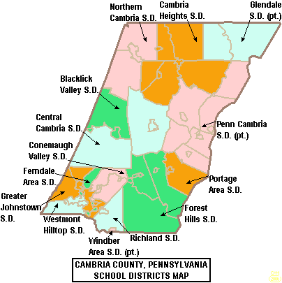
School districts include:
- Blacklick Valley School District
- Cambria Heights School District
- Central Cambria School District
- Conemaugh Valley School District
- Ferndale Area School District
- Forest Hills School District
- Glendale School District (also in Clearfield County)
- Greater Johnstown School District
- Northern Cambria School District
- Penn Cambria School District (also in Blair County)
- Portage Area School District
- Richland School District
- Westmont Hilltop School District
- Windber Area School District (also in Somerset County)
Private schools
- All Saints Catholic School, Cresson
- Appalachian Youth Service
- Arbutus Park Manor, Johnstown
- Bishop Carroll High School (Ebensburg, Pennsylvania)
- Bishop McCort High School, Johnstown
- Cambria County Child Development Center, Ebensburg
- Cambria County Christian School, Johnstown
- Carousel Learning & Development Center, Johnstown
- Cathedral Catholic Academy, Johnstown
- Center for Achievement
- Children's Express Inc., Cresson
- Easter Seal Day Care Center, Johnstown
- Genesis Christian Academy, Johnstown
- Holy Name School, Ebensburg
- Houston House, Johnstown
- Laurel Highlands Therapeutic Academy, Ebensburg
- Little Learning Lamp, Johnstown
- Northern Cambria Catholic School, Nicktown
- Occupational Preparation School, Ebensburg
- Our Mother of Sorrow School, Johnstown
- Richland Academy Montessori School, Johnstown
- Sean Davison School of Driving, Lilly
- St Michael's School, Loretto
- St Sophia Orthodox Christian Academy, Johnstown According to the Pennsylvania Department of Education's Ed Names and Addresses, July 1, 2015
Vocational/Technical schools
- Admiral Peary Vocational Technical School
- Greater Johnstown Career & Technology Center
Recreation
There are two Pennsylvania state parks in Cambria County.
- Prince Gallitzin State Park is named for Demetrius Gallitzin, a Russian nobleman turned Catholic priest who was instrumental in the settlement of Cambria County.
- Laurel Ridge State Park surrounds a 70-mile (113-km) hiking trail that begins in Cambria County and ends at Ohiopyle State Park in Fayette County.
Communities

Under Pennsylvania law, there are four types of incorporated municipalities: cities, boroughs, townships, and, in at most two cases, towns. The following cities, boroughs and townships are located in Cambria County:
City
- Johnstown
Boroughs
- Ashville
- Brownstown
- Carrolltown
- Cassandra
- Chest Springs
- Cresson
- Daisytown
- Dale
- East Conemaugh
- Ebensburg (county seat)
- Ehrenfeld
- Ferndale
- Franklin
- Gallitzin
- Geistown
- Hastings
- Lilly
- Lorain
- Loretto
- Nanty Glo
- Northern Cambria
- Patton
- Portage
- Sankertown
- Scalp Level
- South Fork
- Southmont
- Summerhill
- Tunnelhill (partly in Blair County)
- Vintondale
- Westmont
- Wilmore
Townships
- Adams
- Allegheny
- Barr
- Blacklick
- Cambria
- Chest
- Clearfield
- Conemaugh
- Cresson
- Croyle
- Dean
- East Carroll
- East Taylor
- Elder
- Gallitzin
- Jackson
- Lower Yoder
- Middle Taylor
- Munster
- Portage
- Reade
- Richland
- Stonycreek
- Summerhill
- Susquehanna
- Upper Yoder
- Washington
- West Carroll
- West Taylor
- White
Census-designated places
Census-designated places are geographical areas designated by the U.S. Census Bureau for the purposes of compiling demographic data. They are not actual jurisdictions under Pennsylvania law. Other unincorporated communities, such as villages, may be listed here as well.
- Beaverdale
- Belmont
- Blandburg
- Colver
- Dunlo
- Elim
- Flinton
- Mundys Corner
- Oakland
- Revloc
- Riverside
- Salix
- Sidman
- Spring Hill
- St. Michael
- University of Pittsburgh Johnstown
- Vinco
- Westwood
Unincorporated communities
- Belsano
- Coupon
- Dean
- Dysart
- Elmora
- Elton
- Emeigh
- Fallentimber
- Garmantown
- Glasgow
- Hollentown
- Marsteller
- Mineral Point
- New Germany
- Nicktown
- Parkhill
- Saint Benedict
- Saint Boniface
- Saint Lawrence
- Twin Rocks
Population ranking
The population ranking of the following table is based on the 2010 census of Cambria County.
† county seat
| Rank | City/Town/etc. | Municipal type | Population (2010 Census) |
|---|---|---|---|
| 1 | **Johnstown** | City | 20,978 |
| 2 | **Westmont** | Borough | 5,181 |
| 3 | **Northern Cambria** | Borough | 3,835 |
| 4 | **Elim** | CDP | 3,727 |
| 5 | **† Ebensburg** | Borough | 3,351 |
| 6 | **Belmont** | CDP | 2,784 |
| 7 | **Nanty Glo** | Borough | 2,734 |
| 8 | **Portage** | Borough | 2,638 |
| 9 | **Geistown** | Borough | 2,467 |
| 10 | **Southmont** | Borough | 2,284 |
| 11 | **Patton** | Borough | 1,769 |
| 12 | **Cresson** | Borough | 1,711 |
| 13 | **Gallitzin** | Borough | 1,668 |
| 14 | **Mundys Corner** | CDP | 1,651 |
| 15 | **Ferndale** | Borough | 1,636 |
| 16 | **Oakland** | CDP | 1,578 |
| 17 | **University of Pittsburgh (Johnstown)** | CDP | 1,572 |
| 18 | **Vinco** | CDP | 1,305 |
| 19 | **Loretto** | Borough | 1,302 |
| 20 | **Hastings** | Borough | 1,278 |
| 21 | **Dale** | Borough | 1,234 |
| 22 | **East Conemaugh** | Borough | 1,220 |
| 23 | **Salix** | CDP | 1,149 |
| 24 | **Beaverdale** | CDP | 1,035 |
| 25 | **Lilly** | Borough | 968 |
| 26 | **Colver** | CDP | 959 |
| 27 | **South Fork** | Borough | 928 |
| 28 | **Carrolltown** | Borough | 853 |
| 29 | **Spring Hill** | CDP | 839 |
| 30 | **Scalp Level** | Borough | 778 |
| 31 | **Lorain** | Borough | 759 |
| 32 | **Brownstown** | Borough | 744 |
| 33 | **Sankertown** | Borough | 675 |
| 34 | **Revloc** | CDP | 570 |
| 35 | **Summerhill** | Borough | 490 |
| 36 | **Sidman** | CDP | 431 |
| 37 | **Vintondale** | Borough | 414 |
| 38 | **St. Michael** | CDP | 408 |
| 39 | **Blandburg** | CDP | 402 |
| 40 | **Riverside** | CDP | 381 |
| 41 | **Tunnelhill** (*partially in Blair County*) | Borough | 363 |
| 42 | **Dunlo** | CDP | 342 |
| 43 | **Daisytown** | Borough | 326 |
| 44 | **Franklin** | Borough | 323 |
| 45 | **Ehrenfeld** | Borough | 228 |
| 46 | **Ashville** | Borough | 227 |
| 47 | **Wilmore** | Borough | 225 |
| 48 | **Chest Springs** | Borough | 149 |
| 49 | **Cassandra** | Borough | 147 |
References
References
- "Cambria County, Pennsylvania".
- "PHMC Historical Markers Search". Commonwealth of Pennsylvania.
- "Census - Geography Profile: Cambria County, Pennsylvania". [[United States Census Bureau]].
- "Find a County". National Association of Counties.
- (2008). "Pennsylvania: Individual County Chronologies". The Newberry Library.
- Espenshade, A. Howry. (1925). "Pennsylvania Place Names". [[Pennsylvania State University.
- (August 22, 2012). "2010 Census Gazetteer Files". United States Census Bureau.
- "About the Appalachian Region". Appalachian Regional Commission.
- (July 30, 2018). "The Maps That Show That City vs. Country Is Not Our Political Fault Line". New York Times.
- "Census 2020".
- (2021). "2020 Decennial Census Demographic Profile (DP1)".
- (2021). "2020 Decennial Census Redistricting Data (Public Law 94-171)".
- (2023). "2020 Decennial Census Demographic and Housing Characteristics (DHC)".
- "P004: Hispanic or Latino, and Not Hispanic or Latino by Race – 2000: DEC Summary File 1 – Cambria County, Pennsylvania". [[United States Census Bureau]].
- "P2 Hispanic or Latino, and Not Hispanic or Latino by Race – 2010: DEC Redistricting Data (PL 94-171) - Cambria County, Pennsylvania".
- "P2 Hispanic or Latino, and Not Hispanic or Latino by Race – 2020: DEC Redistricting Data (PL 94-171) - Cambria County, Pennsylvania".
- Leip, David. "Dave Leip's Atlas of U.S. Presidential Elections".
- (November 5, 2024). "2024 Senate Election (Official Returns)".
- Pennsylvania Department of State. (February 5, 2024). "Voter registration statistics by county".
- Geography Division. (January 14, 2021). "2020 Census - School District Reference Map: Cambria County, PA". [[U.S. Census Bureau]].
- "Decennial Census by Decades".
This article was imported from Wikipedia and is available under the Creative Commons Attribution-ShareAlike 4.0 License. Content has been adapted to SurfDoc format. Original contributors can be found on the article history page.
Ask Mako anything about Cambria County, Pennsylvania — get instant answers, deeper analysis, and related topics.
Research with MakoFree with your Surf account
Create a free account to save articles, ask Mako questions, and organize your research.
Sign up freeThis content may have been generated or modified by AI. CloudSurf Software LLC is not responsible for the accuracy, completeness, or reliability of AI-generated content. Always verify important information from primary sources.
Report