From Surf Wiki (app.surf) — the open knowledge base
Boischatel
| Field | Value |
|---|---|
| name | Boischatel |
| settlement_type | Municipality |
| image_skyline | Avenue Royale (Boischatel) 2022.jpg |
| flag_size | 120x100px |
| image_shield | Blason ville ca Boischatel (Québec).svg |
| shield_size | 100x80px |
| motto | *Labeur et Courage* |
| image_map | Boischatel Quebec location diagram.png |
| map_caption | Location within La Côte-de-Beaupré RCM |
| pushpin_map | Canada Central Quebec |
| pushpin_label_position | left |
| pushpin_map_caption | Location in central Quebec |
| coordinates | |
| coordinates_footnotes | |
| subdivision_type | Country |
| subdivision_name | |
| subdivision_type1 | Province |
| subdivision_name1 | |
| subdivision_type2 | Region |
| subdivision_name2 | Capitale-Nationale |
| subdivision_type3 | RCM |
| subdivision_name3 | La Côte-de-Beaupré |
| established_title | Settled |
| established_title1 | Constituted |
| established_date1 | April 3, 1920 |
| government_footnotes | |
| leader_title | Mayor |
| leader_name | Benoit Bouchard |
| leader_title1 | Fed. riding |
| leader_name1 | Montmorency—Charlevoix |
| leader_title2 | Prov. riding |
| leader_name2 | Charlevoix–Côte-de-Beaupré |
| area_footnotes | |
| area_total_km2 | 21.61 |
| area_land_km2 | 20.36 |
| population_footnotes | |
| population_total | 8231 |
| population_as_of | [2021](2021-canadian-census) |
| population_density_km2 | 404.3 |
| population_blank1_title | Pop (2016-21) |
| population_blank1 | 8.5% |
| population_blank2_title | Dwellings |
| population_blank2 | 3128 |
| timezone | EST |
| utc_offset | −5 |
| timezone_DST | EDT |
| utc_offset_DST | −4 |
| postal_code_type | Postal code(s) |
| postal_code | G0A 1H0 |
| area_codes | 418 and 581 |
| blank_name | Highways |
| blank_info | |
| website |
Boischatel () is a municipality in the Capitale-Nationale region of Quebec, Canada. The town was originally called Saint-Jean-de-Boischatel.
Geography
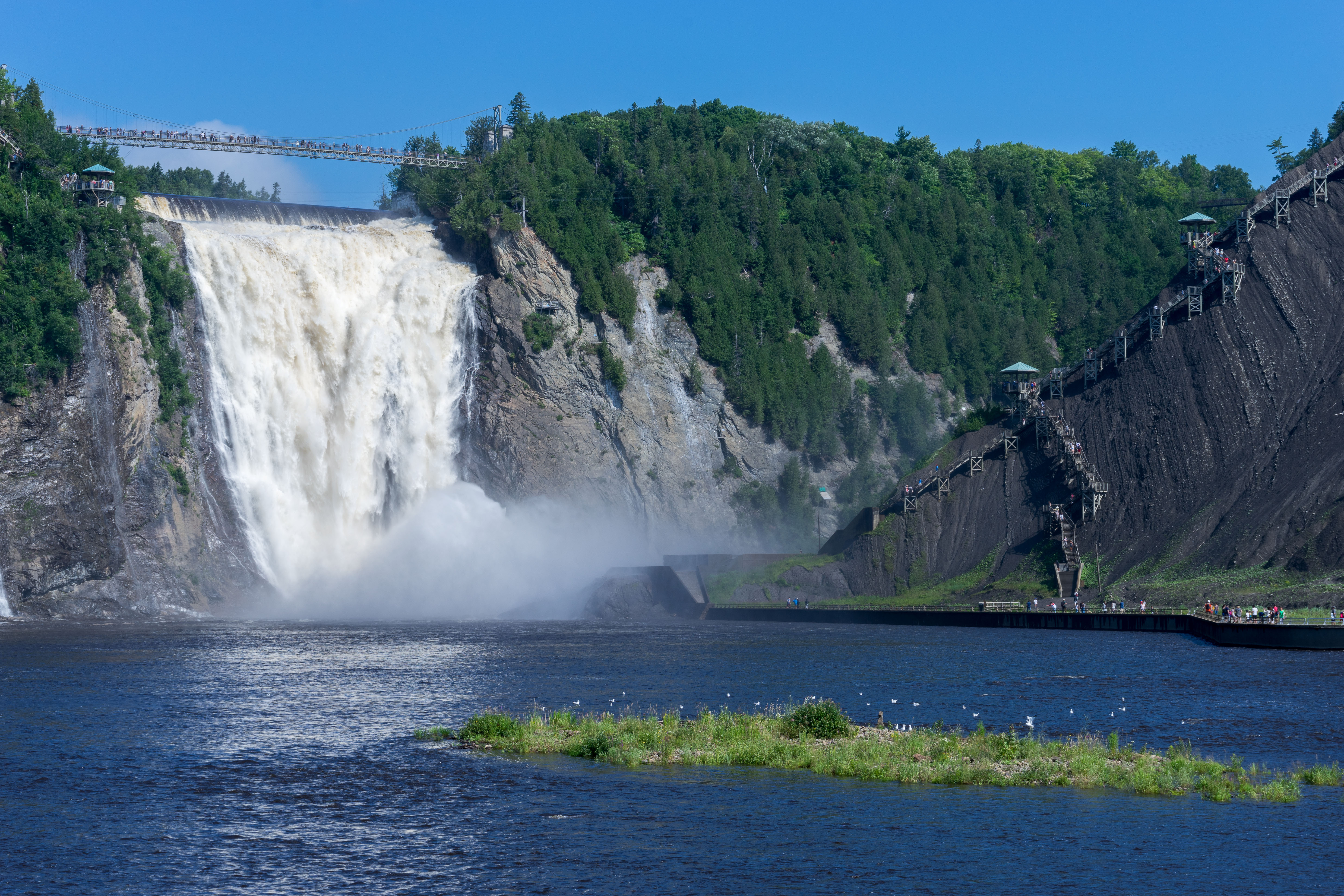
The town itself is located along the Montmorency River and St. Lawrence River. Near the boundary with Beauport are the Montmorency Falls, where 35,000 litres of water per second fall from a height one-and-a-half times greater than that of Niagara Falls.
Rivers flowing through Boischatel:
- Chenal de l'Île d'Orléans
- Ferrée River
- Montmorency River
- St. Lawrence River
History
The area was originally settled around 1664 and called Sault (old French for "waterfall"), due to its proximity to the Montmorency Falls.
The Village Municipality of Saint-Jean-de-Boischatel was formed in 1920 when it ceded from Ange-Gardien, with Séraphin Vézina as its first mayor. It was named in honor of Jean-François de Beauchatel, first aide-de-camp to General Montcalm.
On November 23, 1991, it changed statutes and shortened its name to become the Municipality of Boischatel.
Demographics
| 1921 | 571 | 1931 | 783 | 1941 | 882 | 1951 | 1297 | 1956 | 1461 | 1961 | 1576 | 1966 | 1648 | 1971 | 1685 | 1976 | 2279 | 1981 | 3345 | 1986 | 3662 | 1991 | 3878 | 1996 | 4152 | 2001 | 4303 | 2006 | 5287 | 2011 | 6465 | 2016 | 7587 | 2021 | 8231
Private dwellings occupied by usual residents (2021): 3,050 (total dwellings: 3,128)
First language (2021):
- English as first language: 0.9%
- French as first language: 96.3%
- English and French as first language: 0.6%
- Other as first language: 1.9%
Local government
List of former mayors:
- Séraphin Vézina (1920–1925)
- Joseph Trudelle (1925–1929)
- Arthur Tardif (1929–1937)
- Joseph Trudelle (1937–1939)
- Joseph Racine (1939–1953)
- Maurice Huot (1953–1958)
- Rodolphe Huot (1958–1961)
- Joseph Racine (1961–1965)
- Adjutor Dussault (1965–1969)
- Roland Lavoie (1969–1987)
- Jacques Couture (1987–1994)
- Yvon Coté (1994–1998)
- Yves Germain (1998–2017)
- Benoit Bouchard (2017–present)
References
References
- "Boischatel".
- "Boischatel QC - municipal building Council and more information".
- (2020-07-04). "Man in his 20s lucky to be alive after falling off a cliff into a river after a fight".
- "Profil et histoire". Boischatel.
- "Répertoire des entités géopolitiques: Boischatel (municipalité) 3.4.1920 - ...". Institut généalogique Drouin.
- [[Canada 1996 Census. 1996]], [[Canada 2001 Census. 2001]], [[Canada 2006 Census. 2006]], [[Canada 2011 Census. 2011]], [[Canada 2016 Census. 2016]] census
- {{toponymie. 269411
- {{mamrot. {{#property:P3856
- {{SCref. (2021)
This article was imported from Wikipedia and is available under the Creative Commons Attribution-ShareAlike 4.0 License. Content has been adapted to SurfDoc format. Original contributors can be found on the article history page.
Ask Mako anything about Boischatel — get instant answers, deeper analysis, and related topics.
Research with MakoFree with your Surf account
Create a free account to save articles, ask Mako questions, and organize your research.
Sign up freeThis content may have been generated or modified by AI. CloudSurf Software LLC is not responsible for the accuracy, completeness, or reliability of AI-generated content. Always verify important information from primary sources.
Report