From Surf Wiki (app.surf) — the open knowledge base
Blindbothel
Parish in Cumbria, England
Parish in Cumbria, England
| Field | Value |
|---|---|
| country | England |
| static_image_name | Aikbank Mill - geograph.org.uk - 759346.jpg |
| static_image_caption | Aikbank Mill, Blindbothel |
| coordinates | |
| official_name | Blindbothel |
| population | 148 |
| population_ref | (Parish, 2021) |
| civil_parish | Blindbothel |
| unitary_england | Cumberland |
| lieutenancy_england | Cumbria |
| region | North West England |
| constituency_westminster | Penrith and Solway |
| post_town | COCKERMOUTH |
| postcode_district | CA13 |
| postcode_area | CA |
| dial_code | 01228 |
| 01900 | |
| os_grid_reference | NY118274 |
01900
Blindbothel is a civil parish in the Cumberland district of Cumbria, England. It lies within the Lake District National Park, and is a couple of miles south of the town of Cockermouth. There is no village called Blindbothel; instead the parish comprises a largely rural area containing several small farming hamlets.
History
In the 1870s Blindbothel was described as: :"Blindbothel, a township in Brigham parish, Cumberland; 2 miles W of Cockermouth. Real property, £1,206. Pop., 116. Houses, 19."
Geography
Blindbothel has an area of around 500 ha On the east of Blindbothel is the River Cocker which flows to Cockermouth.
Governance
There are two tiers of local government covering Blindbothel, at parish and unitary authority level: Blindbothel Parish Council and Cumberland Council. The parish is wholly within the Lake District National Park, and so some functions are administered by the Lake District National Park Authority, notably planning. The parish council works in partnership with the three neighbouring parishes of Buttermere, Lorton, and Loweswater as the Melbreak Communities, particularly to respond to issues of flooding along the River Cocker.
Administrative history
Blindbothel was historically a township in the ancient parish of Brigham, in the historic county of Cumberland.
The parish of Blindbothel was included in the Cockermouth Rural District from 1894. In 1934, the parish was enlarged to take in the area of the abolished neighbouring parishes of Mosser and Whinfell. Allerdale was in turn abolished in 2023 when the new Cumberland Council was created, also taking over the functions of the abolished Cumbria County Council in the area.
Population
At the 2021 census, the population was 148.
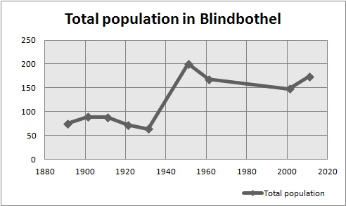
The graph below shows the change in total population in Blindbothel from 1891 to 2011. The total population has gradually increased over time. The sharp increase between the 1931 and 1951 censuses may be attributed to the enlargement of the parish in 1934 to absorb Mosser and Whinfell. Out of the four civil parishes of Buttermere, Lorton and Loweswater, Blindbothel has the smallest population, as the land is mostly for agricultural use. However more recently the adaption for tourism has supplemented the land.
The population density of Blindbothel in 2011 was 0.1 people per hectare. The 2011 census data show the mean age of Blindbothel was 43.7. With most people being in the 45–59 age group. Showing there are mostly older people living in Blindbothel. There were also more males than females living in Blindbothel in 2011, as there were 83 females and 91 males.
Housing
According to the 2011 census data, there are 70 households in total, however there were 72 in 2001, showing a slight decline. The 2011 census data also showed that 33 were married households with no dependent children, suggesting that older couples may have either moved here when their children are no longer dependent, or they have lived in Blindbothel since their children were young, as in another statistic most of the households in Blindbothel in 2011 have 2 people in each household. The type of housing is relatively similar, 45 of the households in Blindbothel in the 2011 census were detached, followed by 17 semi-detached, the housing may have all been built at around the same time, suggesting why.
Education
The Eaglesfield Paddle C. E. Primary Academy is the only school in Blindbothel, according to the 2011 census data, there were 4 schoolchildren living in Blindbothel, so there isn't a high demand for educational facilities there. The former Grant Maintained school, known as 'Paddle School' also offers a nursery class and aims to help children "become independent, confident, self disciplined individuals, proud of their achievements and sensitive to the needs of others"
Industry
In 1881 the most common occupational order for men was agriculture, where as the women were either domestic or didn't have a specified occupation. The land used to be mostly for agriculture and there are little services available in Blindbothel even now, so there are a lack of jobs available in the village, as in the 2011 census data, most people are in professional occupations or are Managers, Directors and Senior Officials. The data also shows that 23 people are retired, so most of the residents of Blindbothel are still economically active.
References
References
- "2021 Census Parish Profiles". Office for National Statistics.
- Marius, John. (1870–1872). "Imperial Gazetteer of England and Wales". Marius.
- (19 May 2010). "Blindbothel". Melbreak Communities.
- (19 May 2010). "Blindbothel". melbreak communities.
- "Blindbothel Parish Council".
- "Planning".
- "The Melbreak Communities".
- (1991). "Guide to the Local Administrative Units of England: Volume II, Northern England". Royal Historical Society.
- {{cite legislation UK. (1973)
- {{cite legislation UK. (2022)
- "Blindbothel (Parish): Key Figures for 2011 Census: Key Statistics". Office for National Statistics.
- "Vision of Britain". Vision of Britain.
- "Blindbothel Township / Civil Parish". GB Historical GIS / University of Portsmouth.
- (19 May 2010). "Blindbothel". melbreak communities.
- "Blindbothel". Cumbria County History Trust.
- "Neighbourhood Statistics; population density". Office for National Statistics.
- "Neighbourhood Statistics; age". Office for National Statistics.
- "Neighbourhood Statistics; sex". Office for National Statistics.
- "Neighbourhood Statistics; households". Office for National Statistics.
- "Neighbourhood Statistics; households". Office for National Statistics; households.
- "Neighbourhood Statistics". Office for National Statistics.
- "Neighbourhood Statistics". Office for National Statistics.
- "Neighbourhood Statistics; households". Office for National Statistics.
- "Paddle School". Eaglesfield Paddle C. E. Primary Academy.
- "Neighbourhood Statistics; schoolchildren". Office for National Statistics.
- "Paddle School". Eaglesfield Paddle C. E. Primary Academy.
- "Blindbothel Industry Statistics". Vision of Britain.
- "Neighbourhood Statistics". Office for National Statistics.
- "Neighbourhood statistics; employment". Office for National Statistics.
This article was imported from Wikipedia and is available under the Creative Commons Attribution-ShareAlike 4.0 License. Content has been adapted to SurfDoc format. Original contributors can be found on the article history page.
Ask Mako anything about Blindbothel — get instant answers, deeper analysis, and related topics.
Research with MakoFree with your Surf account
Create a free account to save articles, ask Mako questions, and organize your research.
Sign up freeThis content may have been generated or modified by AI. CloudSurf Software LLC is not responsible for the accuracy, completeness, or reliability of AI-generated content. Always verify important information from primary sources.
Report