From Surf Wiki (app.surf) — the open knowledge base
Ashby St Mary
Village in Norfolk, England
_-_geograph.org.uk_-_1464859.jpg)
Village in Norfolk, England
| Field | Value |
|---|---|
| country | England |
| coordinates | |
| official_name | Ashby St Mary |
| population | 316 |
| population_ref | (2011) |
| area_total_km2 | 2.03 |
| shire_district | South Norfolk |
| shire_county | Norfolk |
| region | East of England |
| post_town | Norwich |
| postcode_district | NR14 |
| postcode_area | NR |
| os_grid_reference | TG3202 |
| static_image_name | Ashby St Mary Church - geograph.org.uk - 3052988.jpg |
| static_image_caption | St Mary's Church, Ashby St Mary |
the village in South Norfolk
Ashby St Mary, historically Ascebei, is a small village and civil parish in the English county of Norfolk. The civil parish has an area of 2.03 km2 and in the 2001 census had a population of 297 in 115 households, the population increasing to 316 in 120 households at the 2011 Census. For the purposes of local government, the parish falls within the district of South Norfolk.
The village contains a number of heritage-listed buildings, which include a 13th-century church, a War Memorial, and an early 18th Century Hall, Barn and Garden house.
Location
The village is situated 7+1/2 mi south-east of Norwich and 1 mi north of Thurton, with Claxton (to the north), Hellington (to the west) and Carleton St Peter (to the east) all lying a similar distance away. The church has a high tower, a long, low nave, and an impressive Norman doorway. A tombstone in the graveyard depicts a husband and wife (George and Ann Basey) feeding their turkeys and geese; Ann's carving is repeated on the village sign, which was commissioned in 2000 to celebrate the millennium. It also depicts a windmill which stood in the village until at least 1916.
Geography
Ashby's topography is, like most of East Anglia, made up of river meadows and flat agricultural landscape. The geology mostly consists of Cainozoic Sedimentary rock, with a layer of boulder clay and sand laid down in the last ice age. Ashby St Mary has slightly acidic loamy and clayey soils with impeded drainage, and low carbon. The cropping of Ashby is reasonably flexible but more suited to autumn sown crops and grassland.
History
Ashby St Mary, originally called Ascebei has existed for roughly a millennium, as it was recorded in the Domesday Book as;
"Ascebei / As(s)ebei: Roger Bigot; Godric the steward."
The village of Ashby St Mary has existed since the late Saxon era, however, compared to other nearby areas, there was not much activity in the area beforehand, however there is a Bronze Age ringditch, and a Neolithic arrowhead. Thomas de Cottingham, a royal clerk who later became Master of the Rolls in Ireland was appointed rector of Ashby in 1349: he was notorious for pluralism. Ashby Lodge was built in 1788 for the Surgeon General of the East India Company, with a lined facade. Ashby Hall is an early 18th century Country house, but originally there was an older, more elaborate house on the site, there is also a late 17th century Garden house situated nearby, they are now separate private residences. The village used to be situated in the Loddon Hundred.
St. Mary's church
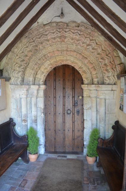
Lending its name to the village, St Mary's church was first built sometime before 1186, in the late Anglo-Saxon era, however, only the foundations of the original church still exists. The nave of the church is Norman, and still retains the typical long low features of a Norman church, the tower is 15th Century, but with later crenellations at the top. The chancel is post 13th century, and the south porch is 16th century, however most of the internal dressings date from the 17th century. Situated in the north of Ashby St Mary, St Mary's church is notable for its Norman doorway, thought to have been carved by the same master mason as both Mundham's St. Peter, and Heckingham's St. Gregory.
The Rectors of St. Mary's date back to the late 13th century, starting with Henry de Lenn in 12--, all the way to Christopher Ellis in 2015. The east-facing window at the head of the chancel has many stained glass elements, and one of the south chancel windows is one of many recreations of The Light of the World used in many East Anglian Churches. Other parts of the church include; the organ, which is medium-sized and was overhauled in 1962, and the Ten Commandments, located at the head of the chancel, are based on the Institutes of the Christian Religion (1536) by John Calvin.
The Church was used in October 2010 by Music composer Jamie Robertson who along with the Poringland Singers Choir recorded an incidental soundtrack to the Big Finish Productions story Doctor Who Relative Dimensions (with Paul McGann, Jake McGann, Carole Ann Ford and Niky Wardley).
Ashby St Mary mill
Ashby St Mary post mill was built c.1758 and remained working for over 150 years. Located on Ashby Common, the mill had a roundhouse and had a 75 foot diameter footprint. The buck had a gallery at the eaves, a balcony porch with a gable end roof. The mill house was sunk one floor below ground level in order to not block wind from the mill. An auxiliary steam engine had been installed by 1900. It continued running up until at least 1906. The mill is first shown on the 1797 Faden's map, and also appears again on both the Bryants map in 1826, and the Greenwoods map in 1834.
Listed buildings
Within Ashby St Mary, there are five listed buildings, all of which are Grade II listed.
| Name | Grading | Description |
|---|---|---|
| St Mary's Church | Grade II* | 12th Century Church |
| (With later additions) | ||
| Ashby St Mary War Memorial | Grade II | War Memorial, |
| erected c.1920 | ||
| Ashby Hall | Grade II | Early 18th Century Country house, |
| including Northern boundary wall | ||
| Ashby Hall Barn | Grade II | Barn, built 1736 |
| Ashby Hall Garden House | Grade II | Late 17th Century Garden house |
Demographics
| Year | Houses | Families | Population | Males | Females | Area (Acres) |
|---|---|---|---|---|---|---|
| 1801 | -- | -- | 186 | 90 | 96 | --- |
| 1811 | -- | -- | 197 | 91 | 106 | --- |
| 1821 | -- | -- | 234 | 110 | 124 | --- |
| 1831 | 57 | -- | 218 | 119 | 99 | 640 |
| 1841 | 59 | -- | 263 | 128 | 135 | --- |
| 1851 | 58 | -- | 249 | 129 | 120 | 487 |
| 1861 | -- | -- | --- | --- | --- | 487 |
| 1871 | -- | -- | --- | --- | --- | 487 |
| 1881 | 56 | -- | 200 | 97 | 103 | 487 |
| 1891 | 55 | -- | 176 | 81 | 95 | 503 |
| 1901 | 46 | 41 | 176 | 91 | 85 | 503 |
| 1911 | 46 | 47 | 174 | 91 | 83 | 503 |
| 1921 | 46 | 47 | 178 | 89 | 89 | 503 |
| 1931 | 48 | 48 | 165 | 83 | 82 | 503 |
| 1941 | -- | -- | --- | 82 | --- | 503 |
| 1951 | 51 | 51 | 163 | 81 | 82 | 503 |
| 1961 | 59 | 59 | 172 | 87 | 85 | 503 |
References
References
- "The Domesday Book Online". domesdaybook.co.uk.
- "Civil Parish population 2011".
- [http://www.south-norfolk.gov.uk/democracy/ashbystmary_parish.asp Ashby St Mary parish information [South Norfolk Council]] {{webarchive. link. (September 28, 2007)
- "Listed Buildings in Ashby St Mary, Norfolk".
- [http://www.norfolkchurches.co.uk/ashbystmary/ashbystmary.htm Ashby St Mary]
- "Norfolk Churches".
- [http://www.ashbystmary.org.uk/parishhistory.htm Ashby St Mary Parish Council] {{webarchive. link. (September 28, 2007)
- "Ashby St Mary Soilscape".
- "Ashby St Mary: landis.org.uk".
- "The Domesday Book Online". domesdaybook.co.uk.
- "The Domesday Book Online". domesdaybook.co.uk.
- "Norfolk Heritage Explorer: MNF10325".
- "Norfolk Heritage Explorer: MNF10324".
- Blomfeld, Francis and Parkin, Charles ''Topographical History of the County of Norfolk'' London 1810 Vol. XI p.147
- "Norfolk Heritage Explorer: MNF48541".
- "Norfolk Heritage Explorer: MNF22788".
- "GenUKi - St Mary's Church, Ashby St Mary".
- "MNF10335 - Norfolk Heritage Explorer".
- "Norfolk Mills - Ashby St Mary post windmill".
- "Faden's map: Ashby St Mary".
- "Norfolk Mills - Ashby St Mary post windmill".
- "Historic England: St. Mary's Church, Ashby St Mary".
- "Historic England: Ashby St Mary: War Memorial".
- "Historic England: Ashby St Mary: Ashby Hall".
- "Historic England: Ashby St Mary: Barn".
- "Historic England: Ashby St Mary: Garden House".
- "Vision of Britain: Ashby St Mary - Houses".
- "Vision of Britain: Ashby St Mary - Families".
- "Vision of Britain: Ashby St Mary - Population".
- "Vision of Britain: Ashby St Mary - Gender".
- "Vision of Britain: Ashby St Mary - Area".
This article was imported from Wikipedia and is available under the Creative Commons Attribution-ShareAlike 4.0 License. Content has been adapted to SurfDoc format. Original contributors can be found on the article history page.
Ask Mako anything about Ashby St Mary — get instant answers, deeper analysis, and related topics.
Research with MakoFree with your Surf account
Create a free account to save articles, ask Mako questions, and organize your research.
Sign up freeThis content may have been generated or modified by AI. CloudSurf Software LLC is not responsible for the accuracy, completeness, or reliability of AI-generated content. Always verify important information from primary sources.
Report