From Surf Wiki (app.surf) — the open knowledge base
Arghandab River
River in Afghanistan
River in Afghanistan
| Field | Value |
|---|---|
| name | Arghandab River |
| name_native | ps-Latn |
| image | Aerial photograph of Kandahar Province in 2011.jpg |
| pushpin_map | Afghanistan |
| pushpin_map_caption | Mouth of the Arghandar River in Afghanistan |
| pushpin_map_alt | Mouth of the Arghandar River in Afghanistan |
| mapframe | yes |
| mapframe-zoom | 6 |
| subdivision_type1 | Country |
| subdivision_name1 | Afghanistan |
| subdivision_type3 | Cities |
| subdivision_name3 | Kandahar |
| Lashkargah | |
| source1_location | North of Sang-e-Masha |
| source1_coordinates | |
| mouth_location | Lashkargah |
| mouth_coordinates | |
| length | 400 km |
| mapframe-zoom = 6 Lashkargah
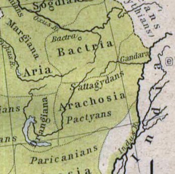
The Arghandab is a river in Afghanistan, about 400 km in length. It rises in Ghazni Province, west of the city of Ghazni, and flows southwest, passing near the city of Kandahar, before joining the Helmand River 30 km below the town of Grishk. In its lower course, it is much used for irrigation, under the control of the Helmand and Arghandab Valley Authority, and the valley is cultivated and populous; yet the water is said to be somewhat brackish. It is doubtful whether the ancient Arachotus is to be identified with the Arghandab or its chief confluent the Tarnak, which joins it on the left 50 km southwest of Kandahar. The Tarnak, which flows south of Kandahar, is much shorter (length about 320 km or 200 miles) and less copious.
Historical background
The river was known to the ancient Persians as the Haraxvaiti in Avestan and Harahuvati in Old Persian, which are cognate with Rigvedic Sarasvati (as described in its "family books"). Scholars such as Boyce and Parpola have identified Greek Arachosia as a Hellenization of the name, meaning the land of the Haraxvaiti. Rigveda's hymn VI.61.2 describes it with the words:
Historian Asko Parpola states: "Arghandab [...] descends from a height of nearly four kilometers down to about 700 meters when it joins the Helmand River, which eventually forms shallow lakes." Sarasvatī- is interpreted to mean "full of lakes".
Some historians, however, assert that the Avestan Haraxvaiti as well as the Rigvedic Sarasvati refer to the Helmand River. The Rigvedic name of Arghandab is then believed to be Drishadvati.{{efn|
- Ram Sharan Sharma: "In the Ṛg Veda, the Sarasvati is called the best of the rivers (naditama). It seems to have been a great river with perennial water... The earliest Sarasvati is considered identical with the Helmand in Afghanistan which is called Harakhwati in the Avesta. But the archaeology of the Helmand valley in the second millennium BC needs adequate attention."
- Rajesh Kocchar: "The Avestan Harahvaiti, phonetically the same as Sarasvati, was known to the Greeks as Etymander and is now called Arghandab. The naditama Sarasvati, however, is to be equated not with the Arghandab but with the Helmand, of which the Arghandab is the main tributary. ... There is an uncanny similarity between the Rgvedic description of Sarasvati and Avestan description of the Helmand."
The ruins at Ulan Robat, supposed to represent the city of Arachosia, are in its basin; and the lake known as Ab-i Istada, the most probable representative of Lake Arachotus, is near the head of the Tarnak, though not communicating with it. The Tarnak is dammed for irrigation at intervals, and almost dries up in the summer.
Upper course
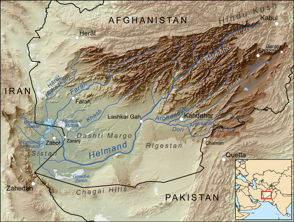
The upper course of the Arghandab river is relatively unexplored. The Historical and Political Gazetteer of Afghanistan cites the explorations of Major G. Lynch in 1841, according to whom the origin of the Arghandab is 20 to 30 miles north of Sang-e-Masha. This places the source in the mountains southwest of the Nawar basin. Lynch also described the upper course of the river as being a "mountain torrent, dashing over great granite rocks and about 3 feet deep where fordable".
Lower course

There is a good deal of cultivation along the river, but few villages. The Kabul-Kandahar Highway passes this way (another reason for supposing the Tarnak to be Arachotus), and the people live off the road to avoid the onerous duties of hospitality.
Dahla dam
In 2008 a project was initiated to rehabilitate the Dahla Dam and associated irrigation system. |access-date=2008-10-07 |url-status=dead |archive-url=https://web.archive.org/web/20080828075512/http://www.aisa.org.af/Downloads/ProvincialProfiles/Kandahar.pdf |archive-date=2008-08-28 | access-date=2008-10-07 | author-link=Doug Schmidt | access-date=2008-10-07 | access-date=2008-10-07 | archive-url=https://archive.today/20130101233324/http://www.afghanistan.gc.ca/canada-afghanistan/ | archive-date=2013-01-01 | url-status=dead |access-date=2008-10-07 |url-status=dead |archive-url=https://web.archive.org/web/20110706192448/http://webcast.international.gc.ca/cpc/PCRA/podcasts/dahla/Dahla_Final_EN.mov |archive-date=2011-07-06 | access-date=2008-10-07
Notes
References
Bibliography
References
- {{EB1911
- (1991). "A history of Zoroastrianism. Vol. III, Zoroastrianism under Macedonian and Roman rule". Brill.
- Buist, George. (1843). "Outline of the Operations of the British Troops in Scinde and Afghanistan: Betwixt Nov. 1838 and Nov. 1841; with Remarks on the Policy of the War". Times Office.
- J. W. Fortescue, [https://archive.org/stream/AHistoryOfTheBritishArmy-VolumeXii/AHistoryOfTheBritishArmy-VolumeXii_djvu.txt History of the British Army, Volume XII: 1839–1852], Macmillan and Co, 1927
This article was imported from Wikipedia and is available under the Creative Commons Attribution-ShareAlike 4.0 License. Content has been adapted to SurfDoc format. Original contributors can be found on the article history page.
Ask Mako anything about Arghandab River — get instant answers, deeper analysis, and related topics.
Research with MakoFree with your Surf account
Create a free account to save articles, ask Mako questions, and organize your research.
Sign up freeThis content may have been generated or modified by AI. CloudSurf Software LLC is not responsible for the accuracy, completeness, or reliability of AI-generated content. Always verify important information from primary sources.
Report