From Surf Wiki (app.surf) — the open knowledge base
Aratula

| Field | Value |
|---|---|
| type | town |
| name | Aratula |
| state | qld |
| image | AratulaAnglicanChurch.JPG |
| caption | St Stephen's Anglican church |
| coordinates | |
| pop | 609 |
| pop_year | |
| pop_footnotes | |
| postcode | 4309 |
| area | 26.2 |
| timezone | AEST |
| utc | +10:00 |
| dist1 | 16.0 |
| dir1 | W |
| location1 | Boonah |
| dist2 | 52.2 |
| dir2 | SSW |
| location2 | Ipswich |
| dist3 | 54.3 |
| dir3 | W |
| location3 | Beaudesert |
| dist4 | 91.3 |
| dir4 | SW |
| location4 | Brisbane |
| lga | Scenic Rim Region |
| stategov | Scenic Rim |
| fedgov | Blair |
| near-n | Frazerview |
| near-ne | Fassifern |
| near-e | Morwincha |
| near-se | Charlwood |
| near-s | Mount Edwards |
| near-sw | Tarome |
| near-w | Tarome |
| near-nw | Frazerview |
| near-n = Frazerview | near-ne = Fassifern | near-e = Morwincha | near-se = Charlwood | near-s = Mount Edwards | near-sw = Tarome | near-w = Tarome | near-nw = Frazerview Aratula is a rural town and locality in the Scenic Rim Region, Queensland, Australia. In the , the locality of Aratula had a population of 609 people.
Geography
Aratula is approximately 52 km by road southwest of Ipswich. The Cunningham Highway enters the locality from the north-east (Fassifern), passes through the town, and exits to the south (Mount Edwards).
Warrill Creek enters the locality from the west (Tarome), flows across the north of the locality (and north of the town), exiting to the east (Morwincha). It is a tributary of the Bremer River, then the Brisbane River, flowing into Moreton Bay.
History
The area was originally known as Carter's Gate, but the name was changed to reflect the railway station name of Aratula.
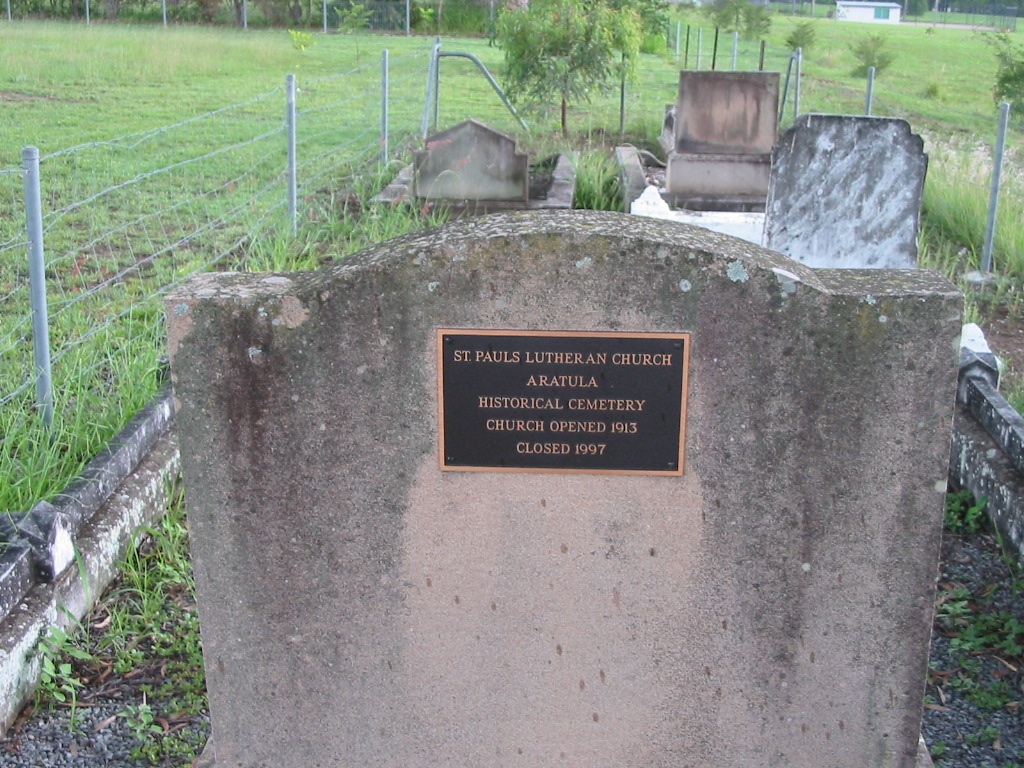
Carter's Gate Provisional School opened on 29 May 1911. It became a State School on 9 January 1913. The name was changed in August 1913 to Aratula State School. The school burned on either 27 or 28 February 1916; the fire was regarded as suspicious as nearby Mount Fraser State School had burned down four months earlier. The school celebrated its centenary in May 2011.[[File:St Pauls Lutheran Church, Aratula, 2005.JPG|thumb|left|St Pauls Lutheran Church, 2005]]St Pauls Lutheran Church opened on 28 March 1914. It closed in 1997. The church building still stands at 57 Elizabeth Street (). There is a Lutheran cemetery behind the church; the first burial was Hermann Gustav Muller in March 1916.
The first stage of the Mount Edwards railway line reached Engelsburg (now Kalbar) on 17 April 1916, but it was not until 7 October 1922 that the second and final stage of the line opened, including the Aratula railway station on the eastern end of Sawmill Road (). The Mount Edwards railway line closed on 1 November 1960.
,_2005.jpg)
Aratula Baptist Church opened on Thursday 25 October 1923. It was on the western side of the Cunningham Highway (approx ). After the church's closure, the church building was relocated in 1972 to the Kalbar Baptist Church to be used as a church hall.
Aratula Post Office opened around 1925 (a receiving office had been open since 1912) and closed in 1987.

On 16 April 1926, the Aratula School of Arts was officially opened by Ernest Bell, the local Member of the Queensland Legislative Assembly. A local public holiday was given to celebrate the occasion. The School of Arts was at 26-28 Elizabeth Street (). The building was sold into private ownership in December 2013 for $115,000.
St Stephen the Martyr Anglican Church was dedicated on Saturday 18 December 1954 by Archbishop of Brisbane Reginald Halse. The first celebration of holy communication was held on St Stephen's Day (Sunday 26 December).
Demographics
In the , the locality of Aratula had a population of 505 people.
In the , the locality of Aratula had a population of 532 people. The locality contained 150 households, in which 50.5% of the population were males and 49.5% of the population were females with a median age of 42, 4 years above the national average. The average weekly household income was $1,187, $251 below the national average.
In the , the locality of Aratula had a population of 609 people.
Heritage listings
Aratula has the following heritage sites:
- St Stephen's Anglican Church, 25 Elizabeth Street
Education
Aratula State School is a government primary (Prep–6) school for boys and girls at 41 Elizabeth Street (). In 2017, the school had an enrolment of 44 students with 7 teachers (4 full-time equivalent) and 6 non-teaching staff (3 full-time equivalent).
There are no secondary schools in Aratula. The nearest government secondary school is Boonah State High School in Boonah to the east.
Amenities

Attractions
Local attractions include nearby Moogerah Peaks National Park, Main Range National Park, Lake Moogerah and ballooning.
Aratula is a common rest-stop for travellers coming eastward across the Great Dividing Range. There is a caravan park and a hotel just off the highway.
References
References
- {{cite QPN. 40970. Aratula. town in Scenic Rim Region
- {{cite QPN. 45107. Aratula. locality in Scenic Rim Region
- "Ipswich to Aratula".
- (14 Feb 1912). "New Name for Receiving-Office". Queensland Times.
- {{Cite QldSchool
- {{cite QSA Agency. 4792. Aratula State School. 12 May 2014
- "Our school". Aratula State School.
- (2 March 1916). "Aratula State School". [[Queensland Times]].
- (2020-01-09). "Our school".
- (26 March 1914). "Advertising". [[Queensland Times]].
- "St Pauls Lutheran Church Aratula Historical Cemetery".
- (8 April 1916). "Aratula News.". National Library of Australia.
- Kerr, John. (1990). "Triumph of narrow gauge : a history of Queensland Railways". Boolarong Publications.
- (1955). "Queensland Two Mile series sheet 2m38". [[Queensland Government]].
- {{Queensland Globe
- Southern Downs Steam Railway. (2009). "'Via recta' - The line that never was".
- [[Queensland Rail. "Rail as foremost mode of travel".
- (31 October 1923). "BAPTIST CHURCH AT ARATULA.". [[The Brisbane Courier]].
- (3 November 1923). "West Moreton News". [[Queensland Times]].
- (1927). "Flinders". [[Queensland Government]].
- Blake, Thom. "Aratula Baptist Church".
- Phoenix Auctions History. "Post Office List". Phoenix Auctions.
- (4 March 1926). "Goolman Council". [[Queensland Times]].
- "26-28 Elizabeth Street, Aratula, Qld 4309".
- "An opportunity too good to miss.@ $185000".
- "St. Stephen's Anglican Church, Aratula". Anglican Parish of Boonah-Harrisville.
- (2019). "Year Book". [[Anglican Archdiocese of Brisbane]].
- {{Census 2011 AUS
- {{Census 2016 AUS
- {{Census 2021 AUS
- "Local Heritage Register". [[Scenic Rim Regional Council]].
- (9 July 2018). "State and non-state school details". [[Queensland Government]].
- "Aratula State School".
- "ACARA School Profile 2017".
This article was imported from Wikipedia and is available under the Creative Commons Attribution-ShareAlike 4.0 License. Content has been adapted to SurfDoc format. Original contributors can be found on the article history page.
Ask Mako anything about Aratula — get instant answers, deeper analysis, and related topics.
Research with MakoFree with your Surf account
Create a free account to save articles, ask Mako questions, and organize your research.
Sign up freeThis content may have been generated or modified by AI. CloudSurf Software LLC is not responsible for the accuracy, completeness, or reliability of AI-generated content. Always verify important information from primary sources.
Report