From Surf Wiki (app.surf) — the open knowledge base
Alboran Sea
Westernmost portion of the Mediterranean Sea

Westernmost portion of the Mediterranean Sea
| Field | Value |
|---|---|
| name | Alboran Sea |
| other_name | Mar de Alborán |
| image | Mar de Alborán - BM WMS 2004.jpg |
| location | Southern Europe and North Africa |
| coordinates | |
| rivers | Guadalhorce River, Guadalfeo River, Adra River (Spain) and Nekor River (Morocco) |
| oceans | Atlantic Ocean |
| catchment | |
| basin_countries | Algeria, Gibraltar (UK), Morocco, and Spain |
| date-built | |
| date-flooded | |
| area | |
| depth | 445 m |
| max-depth | 1500 m |
| volume | |
| shore | |
| elevation | |
| temperature_high | |
| temperature_low | |
| cities | Málaga, Marbella, Motril, Almería and Cartagena, Spain |
| Alhucemas and Nador, Morocco, Gibraltar | |
| pushpin_map | Mediterranean#Morocco#Spain#Algeria |
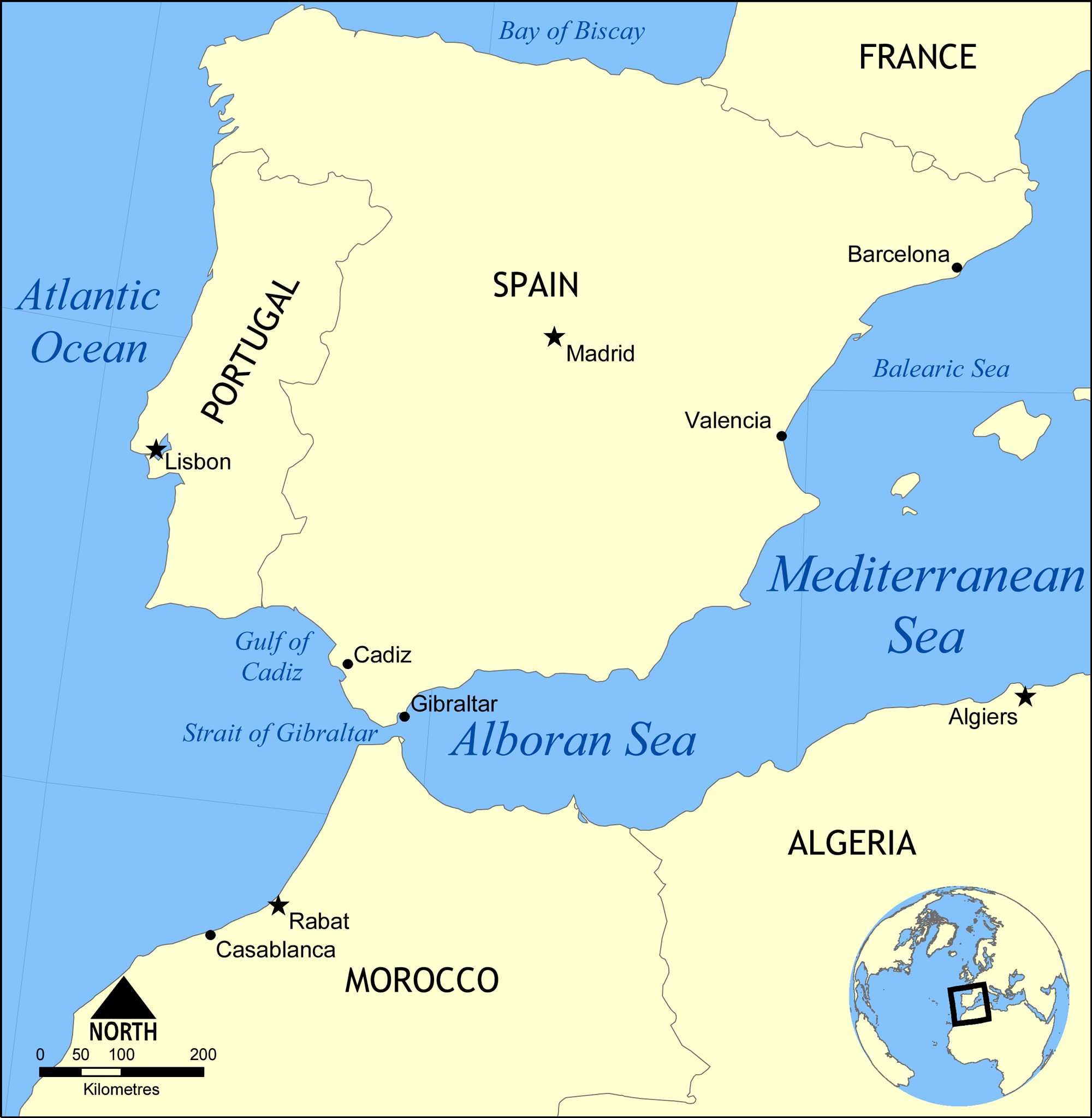
| date-built = | date-flooded = | max-depth = 1500 m Alhucemas and Nador, Morocco, Gibraltar The Alboran Sea is the westernmost portion of the Mediterranean Sea, lying between the Iberian Peninsula and the north of Africa (Spain on the north and Morocco and Algeria on the south). The Strait of Gibraltar, which lies at the west end of the Alboran Sea, connects the Mediterranean with the Atlantic Ocean.
Geography
Its average depth is 445 m and maximum depth is 1500 m.
The International Hydrographic Organization defines the limits of the Alboran Sea as follows:
*On the West.* The Eastern limit of the Strait of Gibraltar: A line joining from tip (Europa Point) of *Cap Gibraltar* in Europe () to the tip of the *Península de Almina* of Ceuta in Africa (). *On the East.* A line joining from *Cabo de Gata* in Andalusia in Europe () to *Cap Fegalo*, near Oran, Algeria in Africa ().
Several small islands dot the sea, including the eponymous Isla de Alborán. Most, even those close to the African shore, belong to Spain.
Geology
The Alboran domain, the seafloor beneath the Alboran Sea (known as the internal zones) together with the surrounding mountains (known as the external zones; the Gibraltar Arc and Atlas Mountains), is mostly made of continental crust and marks the westernmost terminus of the terranes that were subducted between the African and Eurasian Plates when the Tethys Ocean closed. Reoccurring earthquakes at a depth of about 600 km indicate that this subduction is ongoing and that complex interactions between the lithosphere and mantle are forming the region. The internal zones are made of Late Paleozoic to Triassic rocks that were piled up during the Tertiary and has been extended since the Early Miocene.
The seafloor is morphologically complex with several sub-basins, including three main sub-basins named West, East, and South Alboran Basins, ridges, and seamounts. The most prominent structure in the Alboran Sea is the 180 km Alboran Ridge which stretches southwest from the volcanic Alborán Island.
Oceanography
Surface currents in the Alboran Sea, influenced by the prevailing winds, flow eastward, bringing water from the Atlantic into the Mediterranean; deeper subsurface currents flow westward, carrying saltier Mediterranean water over the Gibraltar sill into the Atlantic. Thus there is typically a vertical rotary circulation, also known as a gyre, in the Alboran Sea as a result of this exchange of water.
Ecology
The Alboran Sea is a transition zone between ocean and sea, containing a mix of Mediterranean and Atlantic species. The Alboran Sea is habitat for the largest population of bottlenose dolphins and the last population of harbour porpoises in the western Mediterranean, and is the most important feeding grounds for loggerhead sea turtles in Europe. The Alboran Sea also hosts important commercial fisheries, including sardines and swordfish. In 2003, the World Wildlife Fund raised concerns about the widespread drift net fishing endangering populations of dolphins, turtles, as well as other marine animals. In 2023, the European Union, Morocco, and Algeria agreed to ban bottom fishing practices around Cabliers Bank, protecting the only cold-water coral reef known to be growing in the Mediterranean.
An arc of mountains, known as the Gibraltar Arc, wraps around the northern, western and southern sides of the Alboran Sea. The Gibraltar Arc is made up of the Baetic Cordillera of Southern Spain and the Rif Mountains of Morocco. These mountains, known to ecologists as the Baetic-Rifan complex, comprise one of the Mediterranean's biodiversity hotspots; like the Alboran Sea, the Baetic-Rifan complex represents a transition between the Mediterranean and Atlantic (Macaronesian) ecological zones. The moderating influence of the Atlantic has allowed many relict species in the Baetic and Rif mountains to survive the climatic fluctuations of the last few million years that have caused them to become extinct elsewhere around the Mediterranean basin.
Islands
There are some small islands in the sea:
- Isla de Alborán
- Islas Chafarinas
- Peñón de Alhucemas
- Peñón de Vélez de la Gomera
References
Notes
Sources
- {{Cite journal
- {{Cite book | chapter-url = https://www.researchgate.net/publication/228811649 | access-date = 25 October 2015
- {{Cite journal
References
- (1953). "Limits of Oceans and Seas, 3rd edition". International Hydrographic Organization.
- C. Michael Hogan. 2011. [http://editors.eol.org/eoearth/wiki/Alboran_Sea "Alboran Sea" in. eds. P. Saundry & C. J. Cleveland. ''Encyclopedia of Earth''. (National Council for Science and the Environment) Washington DC]
- (2003-11-20). "WWF warns of dolphin slaughter in Mediterranean". ABC News.
- "Mediterranean countries unite to protect unique deep-sea coral from fishing impacts".
- "Map of Alboran Sea - Alboran Sea Map, World Seas, Alboran Location - World Atlas".
- "Alboran Sea - a sea in Atlantic Ocean".
This article was imported from Wikipedia and is available under the Creative Commons Attribution-ShareAlike 4.0 License. Content has been adapted to SurfDoc format. Original contributors can be found on the article history page.
Ask Mako anything about Alboran Sea — get instant answers, deeper analysis, and related topics.
Research with MakoFree with your Surf account
Create a free account to save articles, ask Mako questions, and organize your research.
Sign up freeThis content may have been generated or modified by AI. CloudSurf Software LLC is not responsible for the accuracy, completeness, or reliability of AI-generated content. Always verify important information from primary sources.
Report