From Surf Wiki (app.surf) — the open knowledge base
219th Street station
New York City Subway station in the Bronx
New York City Subway station in the Bronx
| Field | Value | ||||
|---|---|---|---|---|---|
| name | 219 Street | ||||
| image | 219th_Street_Station.jpg | ||||
| image_caption | Northbound platform | ||||
| address | East 219th Street & White Plains Road | ||||
| Bronx, New York | |||||
| borough | The Bronx | ||||
| locale | Williamsbridge | ||||
| coordinates | |||||
| division | IRT | ||||
| line | IRT White Plains Road Line | ||||
| service | White Plains north local | ||||
| other | {{Unbulleted list | ||||
| platforms | 2 side platforms | ||||
| tracks | 3 (2 in regular service) | ||||
| structure | Elevated | ||||
| opened | |||||
| services | {{Adjacent stations | system=New York City Subway | |||
| line | White Plains local north | left=225th Street | right=Gun Hill Road | note-left= | note-right=}} |
| footnotes | |||||
| route_map | {{NYCS 3-tracked local station | ||||
| 1 | 225th Street | ||||
| 2 | Gun Hill Road | ||||
| code2 | IRT White Plains Road Line | ||||
| inline | y | ||||
| deg | 330 | ||||
| unused | y |
Bronx, New York | NYCT Bus: | MTA Bus: udSHI2gl\udSHI2g+lr\udSHI2gr udSHI2g+l\udSHI2glr\udSHI2g+r
The 219th Street station is a local station on the IRT White Plains Road Line of the New York City Subway. Located at the intersection of 219th Street and White Plains Road in the Williamsbridge neighborhood of the Bronx, it is served by the 2 train at all times and by the 5 train during rush hours in the peak direction.
History
This station was built under the Dual Contracts. It opened on March 3, 1917, as part of an extension of the IRT White Plains Road Line from East 177th Street–East Tremont Avenue to East 219th Street–White Plains Road, providing the Bronx communities of Williamsbridge and Wakefield with access to rapid transit service. Service on the new portion of the line was operated as a four-car shuttle from 177th Street due to the power conditions at the time. The city government took over the IRT's operations on June 12, 1940.
The station was renovated in mid-2006, with work being completed in April 2007. The project cost $13.67 million.
Station layout
This elevated station has three tracks and two side platforms. The center track is not normally used in revenue service. There is a mechanical room below the northbound platform at its north end that is reachable by a closed-off staircase.
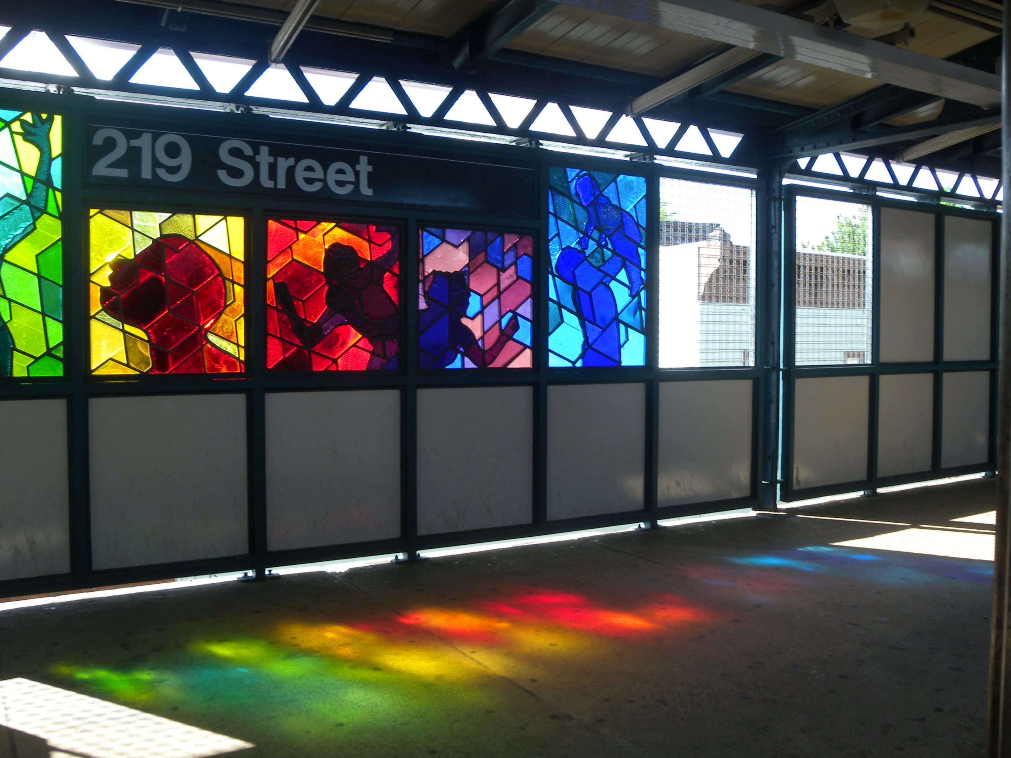
Both platforms have beige windscreens and red canopies with green outlines, frames, and support columns in the center and black, waist-high steel fences at either ends with lampposts at regular intervals. The windscreens have mesh fences at various points. The station signs are in the standard black name plates with white lettering.
The 2006 artwork here is called Homage by Joseph D'Alesandro. It consists of stained glass panels on the platform windscreens that depict colors showing certain human emotions and qualities.
There are track switches that connect the tracks between this station and the next station south, Gun Hill Road.
Exits
This station has one elevated station house beneath the center of the platforms and tracks. Two staircases from each platform go down to a waiting area. The back of the token booth faces this crossunder with a steel fences on either side. On the Wakefield-bound side, there are two exit only turnstiles. On the Manhattan-bound side, there is an emergency gate and a bank of three turnstiles. Outside fare control, two staircases go down to the northwest and southeast corners of 219th Street and White Plains Road. The station house has glass windows.
References
References
- (December 12, 2013). "Annual report. 1916-1917.". Interborough Rapid Transit Company.
- (April 1, 1917). "New Subway Line Opened: White Plains Extension is Now Running to 238th Street". The New York Times.
- (March 4, 1917). "White Plains Road Extension of Subway Opened to the Public; New Branch, Which Runs from 177th to 219th Street, Gives the Williamsbridge and Wakefield Sections of the East Bronx Rapid Transit for the First Time". The New York Times.
- (June 13, 1940). "City Transit Unity Is Now a Reality; Title to I.R.T. Lines Passes to Municipality, Ending 19-Year Campaign". The New York Times.
- (June 13, 1940). "Transit Unification Completed As City Takes Over I. R. T. Lines: Systems Come Under Single Control After Efforts Begun in 1921; Mayor Is Jubilant at City Hall Ceremony Recalling 1904 Celebration". New York Herald Tribune.
- (2006). "MTA 2006 Adopted Budget - February Financial Plan - Part 3". Metropolitan Transportation Authority.
- {{NYCS const. trackref. trackbook3
- "219th Street - Joseph D'Alesandro - Homage, 2006". Metropolitan Transportation Authority.
- (April 2018). "219th Street Neighborhood Map". Metropolitan Transportation Authority.
This article was imported from Wikipedia and is available under the Creative Commons Attribution-ShareAlike 4.0 License. Content has been adapted to SurfDoc format. Original contributors can be found on the article history page.
Ask Mako anything about 219th Street station — get instant answers, deeper analysis, and related topics.
Research with MakoFree with your Surf account
Create a free account to save articles, ask Mako questions, and organize your research.
Sign up freeThis content may have been generated or modified by AI. CloudSurf Software LLC is not responsible for the accuracy, completeness, or reliability of AI-generated content. Always verify important information from primary sources.
Report