From Surf Wiki (app.surf) — the open knowledge base
2010 Central Canada earthquake
none
none
| Field | Value | |||||||
|---|---|---|---|---|---|---|---|---|
| name | 2010 Central Canada earthquake | |||||||
| map2 | {{Location map+ | Canada Quebec | ||||||
| {{Location map~ | Canada Quebec | Canada Quebec | lat | 45.5 | long=-73.57 | label=Montreal | label_size=100 | mark=Green pog.svg}} |
| {{Location map~ | Canada Quebec | lat | 45.42 | long=-75.7 | label=Ottawa | label_size=100 | position=left | mark=Green pog.svg}} |
| {{Location map~ | Canada Quebec | lat | 45.904 | long=-75.497 | mark=Bullseye1.png | marksize=40}} | ||
| relief | 1 | |||||||
| width | 250 | |||||||
| float | right | |||||||
| caption | }} | |||||||
| anss-url | ld2010062300 | |||||||
| isc-event | 14782739 | |||||||
| local-date | ||||||||
| local-time | 1:41 PM (EDT) | |||||||
| timestamp | 2010-06-23 17:41:42 | |||||||
| duration | 30 seconds | |||||||
| magnitude | 5.0 | |||||||
| depth | 16.4 km | |||||||
| location | ||||||||
| type | Reverse | |||||||
| affected | Quebec, Canada | |||||||
| Ontario, Canada | ||||||||
| New York, United States | ||||||||
| damage | ||||||||
| intensity | ||||||||
| pga | ||||||||
| casualties | 1 injured |
| anss-url = ld2010062300 | isc-event = 14782739 | local-date = | local-time = 1:41 PM (EDT) Ontario, Canada New York, United States
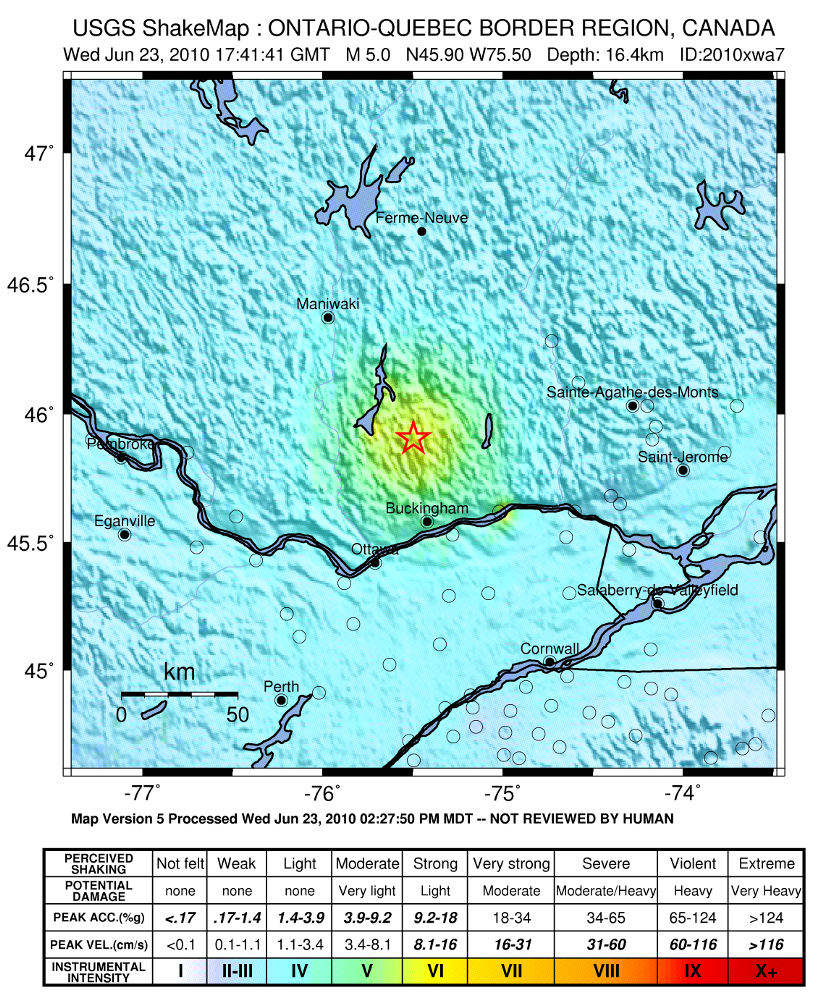
The 2010 Central Canada earthquake occurred with a moment magnitude of 5.0 in Central Canada on 23 June at about 13:41:41 EDT and lasted about 30 seconds. The epicentre was situated approximately 56 km north of Ottawa, Ontario, in the municipality of Val-des-Bois, Quebec. Canada's capital, Ottawa, declared this earthquake as being its most powerful in 65 years.
It was felt across most of Ontario and Quebec, as well as parts of the northeastern United States, in addition to places as far as Chicago, Pittsburgh, Baltimore, Charleston, West Virginia, and Halifax. It was the first moderate earthquake associated with the Western Quebec Seismic Zone since 20 April 2002, when the area was affected by magnitude 5.1 Mw tremors. Southern Ontario was also affected by the 1998 magnitude 5.2 Mw Pymatuning earthquake, associated with a different seismic region (Southern Great Lakes seismic zone).
Although a 5.0 magnitude quake is considered to be moderate, the earthquake's depth (estimates of which vary between 16.4 km and 19.0 km) meant that its effects were more widely felt.
Geology
The magnitude 5.0 Mw intraplate earthquake occurred near the southern edge of the Western Quebec Seismic Zone, known for frequent, but minor tremors, occurring, on average, every five days. Far away from the North American tectonic plate's margin, the regional seismicity is controlled by a series of geologic faults formed over the last billion years by the processes of mountain building, including the Grenville orogeny, and subsequent erosion. The processes causing the earthquakes in the zone are not well understood: the tremors are not linked to particular seismogenic structures, nor are the sources of stress definitively identified. The initial focal mechanism of the 2010 earthquake suggests reverse faulting on a fault trending southeast–northwest. However, the size and depth of this earthquake make it uncertain whether the causative fault can be identified.
Earthquakes of magnitude 4.5 or greater are fairly infrequent in the area, occurring at a rate of a few per decade. Some studies suggest, however, that larger earthquakes of magnitude around 7 may have occurred 4550 and 7060 years BP.
Earthquake
The Globe and Mail reported that "Twitter users as distant as Springfield, Massachusetts, Traverse City, Michigan, and Cincinnati, Ohio reported feeling tremors." The blogosphere and other social media sites like Facebook were swamped by posts referring to the "2010 Ottawa earthquake" or the "2010 Toronto earthquake". Places all the way southward to New Jersey reported a disruptive tremor.
This earthquake occurred as Canadian environment minister Jim Prentice was conducting an interview in Ottawa, and he reported that his chair started to move. The offices of The Globe and Mail were evacuated soon after the tremor. Several media outlets also aired video of a press conference by New Democratic Party Member of Parliament Don Davies being disrupted by the quake.
Damage

Part of Quebec Route 307 was closed due to a partial bridge collapse near Bowman that injured a nearby fisherman. Near the epicentre, many of the telephone networks were out. The Ottawa-Carleton District School Board evacuated most of its schools, but students were allowed to return when the situation was determined to be safe. A number of schools were damaged, including First Avenue Public School, Churchill Alternative School, Blossom Park Public School, Centennial Public School, Connaught Public School, Elgin Street Public School and Hilson Avenue Public School. In Gracefield, Quebec, a state of emergency was declared after several buildings were damaged, including the church, some of the city's administration buildings and a hotel. In the Outaouais, about 1,300 homes lost power. The O-Train Trillium Line in Ottawa was shut down until 5 pm, and the Agence métropolitaine de transport shut down four of five commuter trains in Montreal for a similar period of time in order for lines to be inspected.
Immediately after the quake, cell phone service in Ottawa was down, possibly overloaded by callers. Several windows in Ottawa City Hall shattered, and a chimney in a nearby solicitors' office collapsed. Minor damage was also reported to several city-owned facilities, including two branches of the Ottawa Public Library and two municipal sports arenas, and power was out in part of the downtown Golden Triangle neighbourhood. Office buildings in Ottawa and Toronto were evacuated, and cracks appeared in the Parliamentary Press Gallery building on Parliament Hill. A session of the Senate of Canada was also interrupted, leading to an unprecedented session of the Senate outside on the front lawn of Parliament Hill, in order that a formal adjournment for the day could take place. No serious damage or injuries were reported. In Toronto, Toronto Transit Commission and GO Transit service was uninterrupted, while eastbound Via Rail trains were significantly delayed.
Aftershocks
On 16 March 2011, a magnitude 3.7 or possibly 4.3 aftershock struck Hawkesbury, Ontario, on the Ottawa River Valley and southwest of the initial magnitude 5.0 epicentre. It was felt in places including Ottawa, Montreal and St. Albans, VT.
References
References
- (23 June 2010). "Earthquake shakes central Canada". The Globe and Mail.
- (23 June 2010). "Earthquakes shakes Ontario and Quebec". Toronto Star.
- "Magnitude 5.0 – ONTARIO-QUEBEC BORDER REGION, CANADA". United States Geological Survey.
- (23 June 2010). "Earthquake hits Central Canada". Vancouver Sun.
- (25 June 2010). "Federal, city staff review quake response". Ottawa Citizen.
- (25 June 2010). "Quake shakes Ontarians". [[Northern News]].
- "Mich. feels shake of 5.0 quake in Canada". [[WDIV-TV]].
- (23 June 2010). "Magnitude-5.0 Earthquake Felt in Pittsburgh Area". WPXI Pittsburgh.
- Donaldson, Stan. (23 June 2010). "Canadian earthquake sends tremors through Cleveland, swaying buildings and rattling nerves". [[The Plain Dealer]].
- (23 June 2010). "Canada Earthquake Felt in NH". WMUR New Hampshire.
- (23 June 2010). "Canadian Quake Felt in Chicago". NBC Chicago.
- (23 June 2010). "Canada-centered earthquake felt in Western Pa. – Pittsburgh Post-Gazette". Pittsburgh Post-Gazette.
- "Magnitude 5.0 – ONTARIO-QUEBEC BORDER REGION, CANADA". United States Geological Survey.
- "Historical earthquakes magnitude 5.0 and larger". [[Natural Resources Canada]].
- "Magnitude 5.1 Au Sable Forks, New York". United States Geological Survey.
- (23 June 2010). "Earthquake shakes Ontario and Quebec". Toronto Star.
- "Magnitude 5.2 Pennsylvania 1998 September 25 19:52:52 UTC". United States Geological Survey.
- (23 June 2010). "Earthquake of 5.0 magnitude hits Ontario, Quebec". CTV News.
- MacMillan, Jen. (23 June 2010). "Geologists answer questions on today's quake". The Globe and Mail.
- (23 June 2010). "The Great Canada-Michigan-New York City Earthquake". TIME Magazine.
- "Earthquake zones in Eastern Canada". [[Natural Resources Canada]].
- Forsyth, D.A.. (1981). "Characteristics of the western Quebec seismic zone". [[Canadian Journal of Earth Sciences]].
- Ma, Shutian. (2007). "Western Quebec seismic zone (Canada): Clustered, midcrustal seismicity along a Mesozoic hot spot track". [[Journal of Geophysical Research]].
- "Poster of the Ontario-Quebec border region, Canada Earthquake of 23 June 2010 – Magnitude 5.0". United States Geological Survey.
- Aylsworth, J.M.. (2000). "Did two massive earthquakes in the Holocene induce widespread landsliding and near-surface deformation in part of the Ottawa Valley, Canada?". [[Geology (journal).
- Shannon Proudfoot. (23 June 2010). "Buttons, T-shirts and a Facebook group: Quake's tremors felt online". [[Canwest News Service]].
- (23 June 2010). "Earthquake hits central Canada". CTVnews.
- Aaron Wherry, [http://www.macleans.ca/2010/06/23/in-case-you-were-wondering/ "In case you were wondering..."]. ''[[Maclean's]]'', 23 June 2010.
- (23 June 2010). "Tremblement de terre au Québec". LCN.
- (23 June 2010). "Quebec quake damages buildings, highway". CBC Ottawa.
- Aulakh, Raveena. (23 June 2010). "Earthquake rumbles Ontario and Quebec". Toronto Star.
- [https://ottawacitizen.com/news/Bois+quake+rattles+Ottawa+eastern+North+America/3191688/story.html "5.0 Val-des-Bois quake rattles Ottawa, eastern North America"] {{Webarchive. link. (27 September 2019 . ''[[Ottawa Citizen]]'', 23 June 2010.)
- (23 June 2010). "5.5-Magnitude Earthquake Shakes Canada". Fox News.
- "Earthquake of 5.0 shakes Ontario and Quebec". Yahoo news.
- (23 June 2010). "Earthquake sends senators outside". Toronto Sun.
- Earthquakes. "Magnitude 3.7 – ONTARIO-QUEBEC BORDER REGION, CANADA". United States Geological Survey.
- (16 March 2011}}{{Dead link). "Small earthquake wobbles eastern Ontario, west Quebec". The Ottawa Citizen.
- "M5.2 – Ontario-Quebec border region, Canada". United States Geological Survey.
This article was imported from Wikipedia and is available under the Creative Commons Attribution-ShareAlike 4.0 License. Content has been adapted to SurfDoc format. Original contributors can be found on the article history page.
Ask Mako anything about 2010 Central Canada earthquake — get instant answers, deeper analysis, and related topics.
Research with MakoFree with your Surf account
Create a free account to save articles, ask Mako questions, and organize your research.
Sign up freeThis content may have been generated or modified by AI. CloudSurf Software LLC is not responsible for the accuracy, completeness, or reliability of AI-generated content. Always verify important information from primary sources.
Report