From Surf Wiki (app.surf) — the open knowledge base
2008 Illinois earthquake
Earthquake in Illinois, USA
Earthquake in Illinois, USA
| Field | Value | |||||||
|---|---|---|---|---|---|---|---|---|
| name | 2008 Illinois earthquake | |||||||
| map2 | {{Location map+ | United States | ||||||
| {{Location map~ | United States | lat | 44.51 | long=-88.02 | label_size=100 | label=Green Bay | position=top | mark=Green pog.svg}} |
| {{Location map~ | United States | lat | 43.45 | long=-80.48 | label_size=100 | label=Kitchener | position=right | mark=Green pog.svg}} |
| {{Location map~ | United States | lat | 41.25 | long=-96.0 | label_size=100 | label=Omaha | position=left | mark=Green pog.svg}} |
| {{Location map~ | United States | lat | 33.76 | long=-84.39 | label_size=100 | label=Atlanta | position=right | mark=Green pog.svg}} |
| {{Location map~ | United States | lat | 33.21 | long=-87.53 | label_size=100 | label=Tuscaloosa | position=left | mark=Green pog.svg}} |
| {{Location map~ | United States | lat | 38.45 | long=-87.89 | mark=Bullseye1.png | marksize=40}} | ||
| relief | 1 | |||||||
| position | bottom | |||||||
| width | 250 | |||||||
| float | right | |||||||
| caption | }} | |||||||
| timestamp | 2008-04-18 09:36:59 | |||||||
| isc-event | 10882140 | |||||||
| anss-url | nm606657 | |||||||
| local-date | April 18, 2008 | |||||||
| local-time | 4:36 am CST | |||||||
| magnitude | 5.2 | |||||||
| depth | 14.3 km | |||||||
| location | ||||||||
| type | Strike-slip | |||||||
| affected | Midwestern United States | |||||||
| damages | Limited | |||||||
| intensity | ||||||||
| pga | ||||||||
| casualties | 2 injured |
| isc-event = 10882140 | anss-url = nm606657 | local-date = April 18, 2008 | local-time = 4:36 am CST
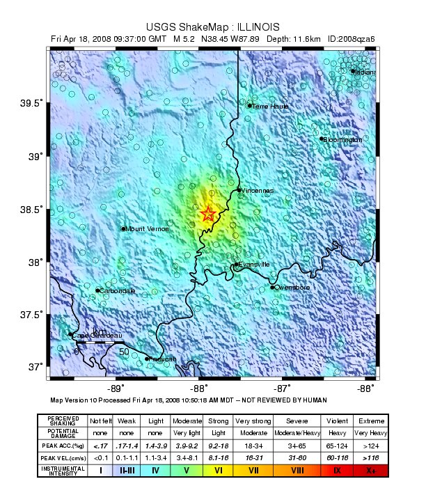
The 2008 Illinois earthquake was one of the largest earthquakes ever recorded in the Midwest state of Illinois. This moderate strike-slip shock measured 5.2 on the moment magnitude scale and had a maximum Mercalli intensity of VII (Very strong). It occurred at 04:36:59 local time on April 18 near Bellmont and Mount Carmel, Illinois, within the Wabash Valley seismic zone. Earthquakes in this part of the country are often felt at great distances.
Tectonic setting
Situated in a stable continental region of the Midwestern United States, the Wabash Valley seismic zone (WVSZ) is an area of dispersed seismic activity that encompasses the border areas of Illinois, Indiana, and Kentucky. This broad, multistate zone of intraplate seismicity lay just to the north of the New Madrid seismic zone and comprises both strike-slip and dip-slip earthquake mechanisms across numerous named faults, grabens, and anticlines.
Earthquake
Rapid development and expansion of services from the United States Geological Survey was taking place in the 2000s in terms of earthquake monitoring and information dissemination services. A number of products from it and its subdivisions that relay information to the public over the Internet were displayed during the event. An automated system from the National Earthquake Information Center, for example, sent an initial notification containing magnitude, depth, and location within two and a half minutes of the mainshock.
Felt area
The shock was felt as far west as Omaha, Nebraska, as far south as Atlanta, Georgia, as far east as Kitchener, Ontario, and West Virginia, and as far north as the Upper Peninsula of Michigan. The earthquake was felt so far away, compared to earthquakes in other regions, because the old, rigid bedrock beneath much of the Midwest allows the seismic waves to propagate further.
Damage
Close to the epicenter in Mount Carmel, Illinois, a woman was briefly unable to exit her home due to a collapsed porch, and a two-story apartment building was evacuated because of loose and falling bricks. The Edwards County sheriff's department took reports of minor damage in West Salem, Illinois. Just across the Wabash River in Indiana, Unit 4 at the Gibson Generating Station automatically shut down due to its vibration sensors, and in Princeton, a woman was cut when a crystal figurine was knocked from a shelf in her home. A man had an eye injury at an unknown location, but medical attention was not sought.
In Louisville, Kentucky, some bricks broke off from an older building near downtown. Slightly further away in St. Louis, Missouri, a portion of the South Kingshighway Boulevard viaduct were closed because of loose pieces of concrete, but whether this was debris-related is unknown, and traffic resumed half an hour later. Several chimneys also collapsed in south St. Louis, the St. Francis de Sales Oratory reported damage to its steeple, and the Basilica of St. Louis King of France reported small fragments from the mosaic ceiling. About 35,000 people in St. Louis County were without power because the Labadie Power Station went offline due to excessive vibrations. Power was restored by midmorning.
Illinois, Indiana, and Kentucky state highway crews investigated if any roads or bridges were damaged in the area. Cracks were reported on U.S. Route 51 near Cairo at the state's southern tip. No roads were reported to be damaged in Kentucky, but inspections were being conducted in the Louisville, Paducah, and Henderson districts, according to the Kentucky Department of Transportation.
Aftershocks
More than 250 aftershocks ranging in magnitude from 0.7 to 4.6 were documented in the month following the mainshock, including the largest, which occurred later in the morning. The other stand-out shocks in the sequence were the M4 event on April 21, an M4.2 event on April 25, and a M3.4 shock on June 5 CDT.
Response
Many precautionary measures were taken, including several evacuations. All Vincennes University dormitories were evacuated as a precaution, but no damage was discovered and students were allowed to return after about 45 minutes. A coal mine in Gibson County, Indiana, was also evacuated, but miners returned to work shortly afterwards. The Gibson County 9-1-1 system was briefly knocked offline due to a flood of calls, but after about 15 minutes, service was restored.
References
References
- (2002). "Interpreting the Earthquake Source of the Wabash Valley Seismic Zone (Illinois, Indiana, and Kentucky) from Seismic-reflection, Gravity, and Magnetic-intensity Data". Seismological Research Letters.
- (2009). "Fault-Plane Determination of the 18 April 2008 Mount Carmel, Illinois, Earthquake by Detecting and Relocating Aftershocks". Bulletin of the Seismological Society of America.
- (18 April 2008). "Geological survey now registers quake at 5.2". The Southern Illinoisan.
- Canwest News Service. (April 18, 2008). "Illinois earthquake rattles southern Ontario". [[National Post]].
- (19 April 2008). "Nope, you weren't dreaming". Chicago Tribune.
- (April 18, 2008). "5.2 earthquake rocks the Midwest". [[WLS-TV.
- http://www.tristate-media.com/articles/2008/04/21/pdclarion/news/news1.txt{{dead link. (September 2011)
- "Update: Aftershocks rattle Tri-State Friday". [[WFIE]].
- Easter, Laura. (April 22, 2008). "Residents 'obviously shaken and concerned' by earthquake activity, Colby Rigg says". Daily Republican Register, Tri-State Media.
- Kristen Gosling. (April 18, 2008). "Lanes on KingsHighway Viaduct Reopen". [[KSDK]].
- "Strong Aftershock Felt in Midwest". AHN – All Headline News.
- "Bridge Inspections Underway in Kentucky". WXIX-TV Fox19 News.
- (2008). "The April 18, 2008 illinois Earthquake: An ANSS Monitoring Success".
- "Significant Earthquake Rumbles Early Friday". WRAY Radio.
- National Geophysical Data Center / World Data Service (NGDC/WDS). (1972). "Significant Earthquake Database". [[National Geophysical Data Center]], [[National Oceanic and Atmospheric Administration.
- "M 5.2 – 11 km WNW of Mount Carmel, Illinois". United States Geological Survey.
This article was imported from Wikipedia and is available under the Creative Commons Attribution-ShareAlike 4.0 License. Content has been adapted to SurfDoc format. Original contributors can be found on the article history page.
Ask Mako anything about 2008 Illinois earthquake — get instant answers, deeper analysis, and related topics.
Research with MakoFree with your Surf account
Create a free account to save articles, ask Mako questions, and organize your research.
Sign up freeThis content may have been generated or modified by AI. CloudSurf Software LLC is not responsible for the accuracy, completeness, or reliability of AI-generated content. Always verify important information from primary sources.
Report