From Surf Wiki (app.surf) — the open knowledge base
1959 Hebgen Lake earthquake
Earthquake in southwestern Montana, USA
Earthquake in southwestern Montana, USA
| Field | Value | |
|---|---|---|
| timestamp | 1959-08-18 06:37:20 | |
| isc-event | 882673 | |
| anss-url | iscgem882673 | |
| title | 1959 Hebgen Lake earthquake | |
| local-date | ||
| local-time | 23:37 (MST) | |
| map | {{Location map | Montana#USA |
| AlternativeMap | USA_Montana_relief_location_map.jpg | |
| lat_deg | 44.712 | |
| lon_deg | -111.215 | |
| mark | Bullseye1.png | |
| marksize | 40 | |
| position | top | |
| width | 250 | |
| float | right | |
| caption | }} | |
| magnitude | 7.2 | |
| type | Dip-slip | |
| intensity | ||
| location | ||
| ~15 mi north of | ||
| West Yellowstone, Montana, U.S. | ||
| countries affected | southwestern Montana, | |
| Idaho, Wyoming | ||
| casualties | 28+ dead |
| isc-event = 882673 | anss-url = iscgem882673 | local-date = | local-time = 23:37 (MST) ~15 mi north of West Yellowstone, Montana, U.S. Idaho, Wyoming The 1959 Hebgen Lake earthquake (also known as the 1959 Yellowstone earthquake) occurred in the western United States on August 17 at 11:37 pm (MST) in southwestern Montana.
The earthquake measured 7.2 on the moment magnitude scale,
The 1959 quake was the strongest and deadliest earthquake to hit Montana, the second being the 1935–36 Helena earthquakes that left four people dead. It also caused the worst landslides in the northwestern United States since 1927.
Earthquake
The earthquake occurred at 11:37 p.m. (MST) with a magnitude of 7.2 . During the quake, the surrounding landscape dropped as much as 20 ft and shockwaves caused numerous seiches to surge across Hebgen Lake for 12 hours. Water pushed by the seiches poured over Hebgen Dam which did not collapse.
The earthquake struck Madison Canyon, an area to the west of Yellowstone National Park. Several nearby campgrounds were occupied by vacationing campers and tourists at the time.
Although magnitude estimates for the 1959 earthquake vary (the United States Geological Survey recorded the quake at both 7.3 and 7.5, now calculated by the ISC as 7.2 The landslide caused by this quake was the largest since an earthquake in Wyoming in 1925 caused a landslide amounting to 50 e6cuyd of rock and debris that left 28 people dead. The death toll from the quake was also the highest since the 1925 earthquake and most recent for the Northwestern United States since an earthquake in 1927 that left seven people dead. The 1959 earthquake was also the most damaging earthquake to occur in Montana since the 1935–36 earthquakes that left four people dead. The Hebgen Lake area also experienced earthquakes again in 1964, 1974, 1977 and 1985.
Effects
The landslides caused by the quake carried 50 e6cuyd of rock, mud and debris down into the valley and created hurricane-force winds strong enough to toss cars. In Madison Canyon, the landslide swept away a family of six, four of whom perished. Two more fatalities were also reported in nearby Cliff Lake to the south. In Rock Creek, tourists camping there were caught off guard by the quake and landslide, which swept them into the creek. The earthquake caused a seiche which inundated trailers and tents, uprooted trees, and injured one additional person.

In nearby Yellowstone National Park, 289 springs erupted in geysers, 160 of which had never had geyser activity before, and cracks ruptured the surface. Near Old Faithful, the earthquake damaged the Old Faithful Inn, forcing guests there to evacuate. Landslides caused by the quake blocked a road between Mammoth and Old Faithful, damaging a bridge inside the park. Buildings at the Montana State University campus also sustained quake damage.
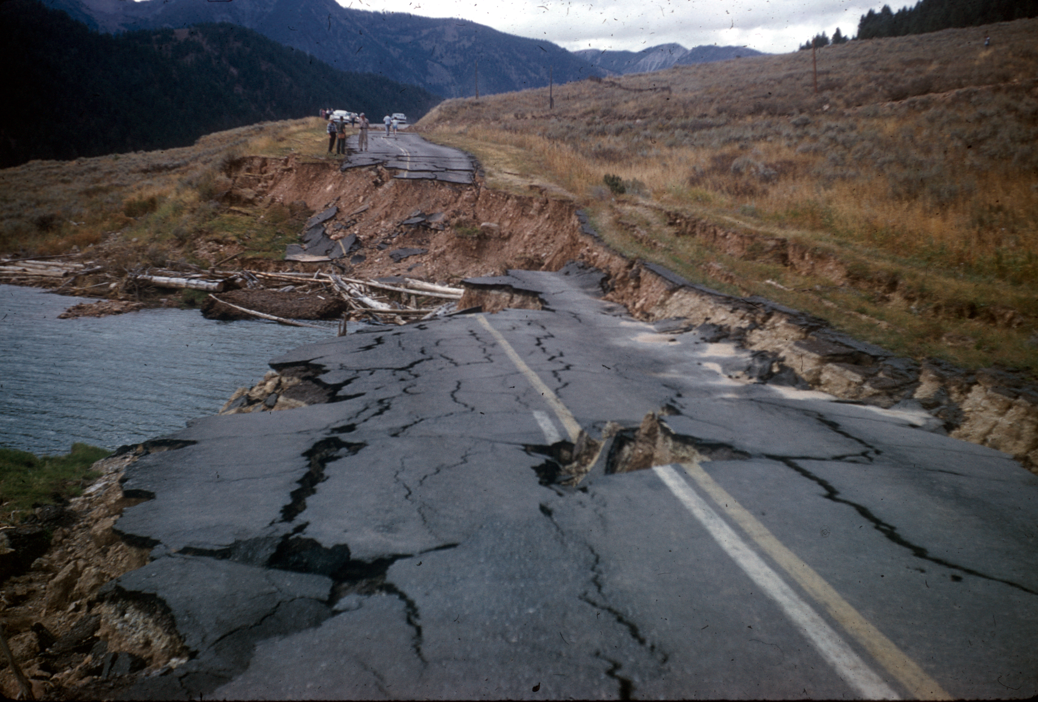
Areas around Hebgen Lake were also affected as the quake caused parts of the lake to rise 8 ft. Roads and highways running along the shores of the lake collapsed into the water. In West Yellowstone, the earthquake damaged a courthouse
| State | Reported deaths | Confirmed deaths | Unaccounted |
|---|---|---|---|
| Montana | 0 | date=August 2020}} | date=August 2020}} |
| Idaho | 8 | 0 | 0 |
The earthquake also caused damage and fatalities outside of Montana. In Raynolds Pass in Eastern Idaho, a landslide killed eight more people. Seismic waves from the quake were reported in Boise and Macks Inn, Idaho, causing minor well and sewer damage. The final death toll from the earthquake was 28, although some newspaper reports suggested the death toll was high as 50–60. US$11 million (equivalent to $ million in ) in damage was caused.
The quake was felt outside the region. In Salt Lake County, Utah, police officers at the local jail and officials at the Salt Lake Municipal Airport felt the effects of the earthquake. Water levels in wells were affected as far away as Hawaii, 3,200 mi away, where water in wells fluctuated .10 ft, and .01 ft in Puerto Rico. Levels in nearby Idaho fluctuated as much as 10 ft.
Earthquake Lake
The landslide caused by the quake blocked the flow of the Madison River. Fearing that the pressure caused by the rising water would result in a catastrophic flood, the Army Corps of Engineers began to cut a 250 foot wide and 14 foot deep channel into the slide. By September 10, water began to flow through the channel. To prevent more erosion by the flowing water, the Army Corps cut another 50 foot channel which was completed on October 29. The construction of the two channels cost US$1.7 million (equivalent to $ million in ).
Aftermath
Amateur radio operator Warren Russel, operating radio-station coded K7ICM transmitted news of the quake at 11:43 p.m. (MST). At 11:50 p.m., another amateur (Fr. Francis A. Peterson of St. Anthony in Idaho) contacted the Idaho State Police who in turn contacted their headquarters in Boise. The Montana Highway Patrol, Montana State Civil Defense and the Montana Department of Fish, Wildlife and Parks also received word of the earthquake and its effects. The geography of the area plus the damage from the earthquake disrupted and/or obstructed radio communications, making broadcasting accurate information about the quake's effects difficult.
The Yellowstone County Chapter of the American Red Cross, The Salvation Army and various other local, national, and organizations from multiple states sent aid to the victims of the earthquake. The Red Cross also set up temporary housing in Bozeman and the Wyoming Department of Health sent 200 trailers to the Yellowstone area to be used as hospitals. Because the majority of the roads in and around the Yellowstone area were either damaged or blocked by the landslides and the quake, equipment and personnel from the United States Air Force and the U.S. Forest Service were brought in to transport the injured to nearby hospitals outside the quake zone and to perform search and rescue missions in Madison Canyon. 300 people trapped in the canyon were rescued. Rescuers found five to nine bodies in the earthquake zone. Residents from the town of Ennis were evacuated to Virginia City and Butte.
Senators and Representatives Frank Moss (D-Utah), John Baldwin (R-California), Harold Johnson (D-California), Lee Metcalf (D-Montana), Leroy Anderson (D-Montana), Tom Morris (D-New Mexico) and Gracie Pfost (D-Idaho) flew over and surveyed the disaster area. The Senate Interior and Insular Affairs Committee requested Montana Governor J. Hugo Aronson to declare the areas hardest hit by the quake a disaster area. Wyoming Governor John J. Hickey provided help and equipment in the aftermath of the quake. The Montana National Guard was called to the quake area to prevent looting of campsites left abandoned by the quake. The Idaho National Guard were also sent to the quake area. The Montana Highway Department began clearing roads of debris and mud. The work was slowed by aftershocks and smaller landslides. On August 19, US Highway 20 and US Highway 191 were reopened while Montana State Highway 1 remained closed. Three bridges in Duck Creek, Cougar Creek and Madison Canyon were repaired and reopened as well. Because of the threat of gasoline spilling into the Missouri River, a local pipeline company built an emergency pumping station. The Montana Power Company surveyed Hebgen Dam and found it sustained minimal damage. Hebgen Lake was completely drained for crewmen to make repairs and to rid it of dead or dying fish. Overall repairs to the Yellowstone National Park amounted to US$2.6 million (equivalent to $ million in ).
Fifty people including police officers, members of the Red Cross and others held a memorial service a mile north of the slide in Madison Canyon for campers presumed buried under the quake-induced landslide. The services lasted for 15 minutes. The U.S. Forest Service placed a plaque on one of the boulders that fell during the quake to honor the 19–21 people who were killed during the quake-induced landslide.
References
References
- Healy, Donna. (1999). "40 Years After the Hebgen Lake Earthquake". The Billings Gazette.
- (2007). "Summary of Hebgen Lake 1959 Earthquake". University of Utah.
- Christopherson, Edmund. (1962). "The Night the Mountain Fell: The Story of the Montana-Yellowstone Earthquake". Lawton Printing Inc..
- (August 21, 1959). "Grim Search Continues for Victims of Quake". Deseret News.
- (August 22, 1959). "Lake, Slide May Hide Victims of Quake". Bend Bulletin.
- (1993). "Largest Earthquake in Montana". United States Geological Survey.
- (2005). "Explosions, Earthquakes, And Volcanic Eruptions—What's in Yellowstone's Future?". United States Geological Survey.
- (1975). "1975 Seismic Geyser and Its Bearing on the Origin and Evolution of Geysers and Hot Springs of Yellowstone National Park". Geological Society of America Bulletin.
- (August 18, 1959). "Quake Hits Hebgen: Death Toll Mounts in Face of Major Montana Disaster". University of Utah.
- (August 2020}} In [[Butte, Montana). "Severe Earthquake Rocks Butte: Minor Damage Widespread in Mining City". University of Utah.
- (August 18, 1959). "16 Reported Dead as Quakes Smash West Yellowstone Area: Dam Cracked; Mountains Fall". University of Utah.
- The blockage caused the water to rise and formed a new lake, which was later to be named [[Quake Lake]] (officially Earthquake Lake)..{{gnis. 793664. Earthquake Lake
- ISC. (2015). "ISC-GEM Global Instrumental Earthquake Catalogue (1900–2009)". [[International Seismological Centre]].
- (1993). "Seismicity of the United States, 1568–1989 (Revised)". [[United States Government Printing Office]].
- Yeats, R.. (2012). "Active Faults of the World". [[Cambridge University Press]].
This article was imported from Wikipedia and is available under the Creative Commons Attribution-ShareAlike 4.0 License. Content has been adapted to SurfDoc format. Original contributors can be found on the article history page.
Ask Mako anything about 1959 Hebgen Lake earthquake — get instant answers, deeper analysis, and related topics.
Research with MakoFree with your Surf account
Create a free account to save articles, ask Mako questions, and organize your research.
Sign up freeThis content may have been generated or modified by AI. CloudSurf Software LLC is not responsible for the accuracy, completeness, or reliability of AI-generated content. Always verify important information from primary sources.
Report