From Surf Wiki (app.surf) — the open knowledge base
1927 Gulang earthquake
1927 severe earthquake centered near Gulang, Gansu Province, China
1927 severe earthquake centered near Gulang, Gansu Province, China
| Field | Value | |
|---|---|---|
| title | 1927 Gulang earthquake | |
| timestamp | 1927-05-22 22:32:49 | |
| anss-url | iscgem909273 | |
| isc-event | 909273 | |
| local-date | ||
| local-time | 06:32 | |
| map2 | {{Location map many | Tibetan Plateau |
| lat | 37.39 | |
| long | 102.31 | |
| mark | Bullseye1.png | |
| marksize | 50 | |
| position | top | |
| width | 250 | |
| float | right | |
| caption | }} | |
| magnitude | 7.7 Mw | |
| fault | Haiyuan Fault | |
| location | ||
| countries affected | Gansu, Republic of China | |
| Xining | ||
| intensity | ||
| casualties | 40,912 |
|anss-url = iscgem909273 |isc-event = 909273 |local-date= |local-time = 06:32 Xining
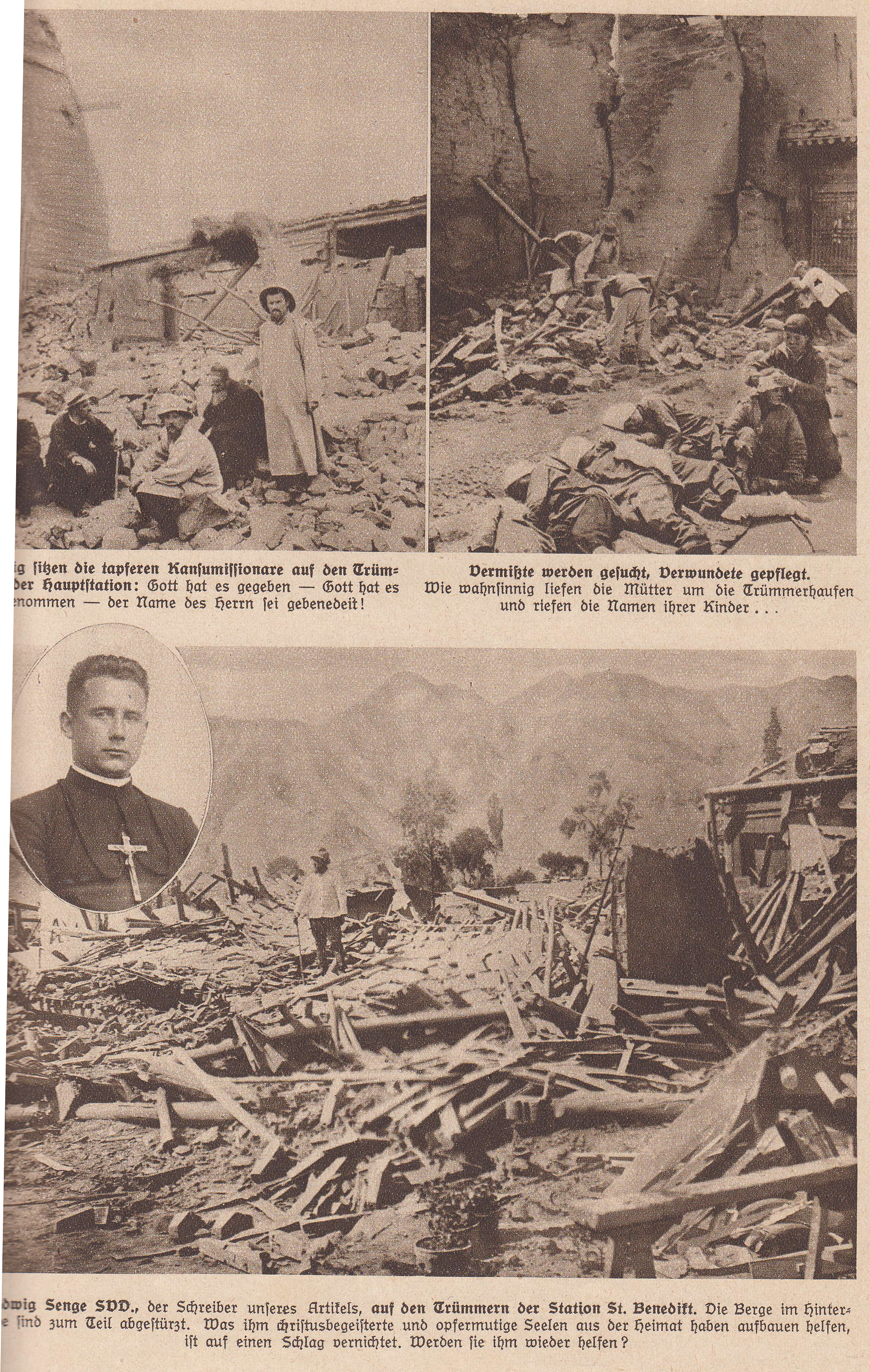
The 1927 Gulang earthquake occurred at 06:32 a.m. on 23 May (22:32 UTC on 22 May). This 7.7 magnitude event had an epicenter near Gulang, Gansu in the Republic of China. There were 40,912 deaths. It was felt up to 700 km (435 mi) away.
Geology
The continental collision between the Indian plate and the Eurasian plate has formed the Himalayas and the large uplifted area of the Tibetan Plateau. The northeastern part of Tibet is affected by the eastward lateral spreading of the Tibetan Plateau. This spreading is accommodated by a series of sinistral (left-lateral) strike-slip faults, including the Altyn Tagh, Haiyuan, Kunlun and Xianshuihe faults, combined with thrusting on the Longmenshan fault. The earthquake ruptured the complex thrust fault system in the Qilian Mountains transpressional zone, formed at a restraining bend on the Haiyuan fault. Another segment of the Haiyuan fault was responsible for the 1920 Haiyuan earthquake.
Damage

In the area of greatest intensity, all cave dwellings and 90% of houses were destroyed. In Gulang, almost the only thing left standing was a 20 m (66 ft) long section of the city walls and some decorated archways. In Gulang county 4,000 people and 30,000 domestic animals were killed. In Wuwei, most of the city walls collapsed as did many temples, towers and civilian houses, 35,000 people and 200,000 horses and oxen were killed. In the area around Yongchang many primary schools, forts, stockaded villages and temples were destroyed, killing 809 people. In Shandan County more than 5,800 houses were destroyed and many cave dwellings collapsed, leaving 886 people dead.
The ground was extensively fissured, with fissures up to 14 km (8.7 mi) in length, 6–13 m (20–43 ft) wide and 7 m (23 ft) deep. A large landslide at Dongchuan buried several villages and blocked the road for a year.
Characteristics
The magnitude of this earthquake has been variously calculated as 7.7 on the moment magnitude scale and 8.0–8.3 on the surface-wave magnitude scale. The earthquake was the result of thrust and strike-slip faults rupturing simultaneously. Three zones of surface ruptures were associated with the earthquake. Left-lateral displacements of 2.4–7.5 m occurred along a 120 km segment of the Lenglongling Fault. A 23 km long rupture occurred at the eastern end of the Huangcheng–Shuangta Fault with offsets of 0.1–2.8 m. Rupture on the Huangcheng–Shuangta Fault comprised reverse slip. The Southern Wuwei Basin Fault produced 42 km of vertical offsets in the range of 0.6–2.8 m.
References
References
- {{cite anss. M 7.7 - 31 km SSW of Wuwei, China. 1927. iscgem909273
- "NOAA page on the earthquake".
- "Historic Earthquakes Tsinghai, China 1927 May 21 22:32 UTC". United States Geological Survey.
- Gaudemer, Y.. (2007). "Partitioning of crustal slip between linked, active faults in the eastern Qilian Shan, and evidence for a major seismic gap, the 'Tianzhu gap', on the western Haiyuan Fault, Gansu (China)". [[Geophysical Journal International]].
- Cavalié, O.. (2008). "Measurement of interseismic strain across the Haiyuan fault (Gansu, China), by InSAR". Earth and Planetary Science Letters.
- Xu, X.. (2010). "Five Short Historical Earthquake Surface Ruptures near the Silk Road, Gansu Province, China". Bulletin of the Seismological Society of America.
- (2020). "A New Tectonic Model for the 1927 M8.0 Gulang Earthquake on the NE Tibetan Plateau". Tectonics.
This article was imported from Wikipedia and is available under the Creative Commons Attribution-ShareAlike 4.0 License. Content has been adapted to SurfDoc format. Original contributors can be found on the article history page.
Ask Mako anything about 1927 Gulang earthquake — get instant answers, deeper analysis, and related topics.
Research with MakoFree with your Surf account
Create a free account to save articles, ask Mako questions, and organize your research.
Sign up freeThis content may have been generated or modified by AI. CloudSurf Software LLC is not responsible for the accuracy, completeness, or reliability of AI-generated content. Always verify important information from primary sources.
Report