From Surf Wiki (app.surf) — the open knowledge base
1700 Cascadia earthquake
Megathrust earthquake in the Pacific Northwest region

Megathrust earthquake in the Pacific Northwest region
| Field | Value | |||||
|---|---|---|---|---|---|---|
| name | 1700 Cascadia earthquake | |||||
| map2 | {{Location map+ | North America | ||||
| relief | 1 | |||||
| width | 250 | |||||
| {{Location map~ | North America | lat | 45 | long=-125 | mark=Bullseye1.png | marksize=40}} |
| pre-1900 | yes | |||||
| local-date | ||||||
| local-time | circa 21:00 PST | |||||
| magnitude | 8.7–9.2 | |||||
| depth | ||||||
| location | ||||||
| fault | Cascadia subduction zone | |||||
| type | Megathrust | |||||
| pga | ||||||
| tsunami | Yes | |||||
| casualties | Many Native Americans killed or displaced by shaking or subsequent tsunami | |||||
| anss-url | official17000127050000000 |
| pre-1900 = yes | local-date = | local-time = circa 21:00 PST | anss-url = official17000127050000000 The 1700 Cascadia earthquake occurred along the Cascadia subduction zone on January 26, 1700, with an estimated moment magnitude of 8.7–9.2. The megathrust earthquake involved the Juan de Fuca plate from mid-Vancouver Island, south along the Pacific Northwest coast as far as northern California. The plate slipped an average of 20 m along a fault rupture about 1000 km long.
The earthquake caused a tsunami which struck the west coast of North America and the coast of Japan. Japanese tsunami records, along with reconstructions of the wave moving across the ocean, put the earthquake at about 9:00 PM Pacific Time on the evening of 26 January 1700.

Japanese records
The earthquake took place at about 21:00 PT on January 26, 1700 (NS). Although there are no written records for the region from the time, the timing of the earthquake has been inferred from Japanese records of a tsunami that does not correlate with any other Pacific Rim quake. The Japanese records exist primarily in the modern-day Iwate Prefecture, in communities such as Tsugaruishi, Miyako (Kuwagasaki) and Ōtsuchi. The fact that the waves were recorded as striking Ōtsuchi and Kuwagasaki on the same day and hour helped researchers pinpoint the estimated date, time, and place of origin of the earthquake.
According to Japanese records, destructive waves hit towns along the Pacific Coast of Japan on the 8th and 9th days of the 12th month of Genroku 12, which would be equivalent to January 27 and 28, 1700. Based on the damage reports in Japanese records, the maximum wave heights were estimated to be in the range of 2–5 meters. At Kuwagasaki, 13 houses were destroyed by flooding and 20 in a subsequent fire, representing about 10% of all buildings in the town. At Ōtsuchi, two buildings, two salt kilns, and some fields and paddies were damaged. At Miho, the village headman observed the waves and warned the villagers to flee to higher ground. No damage was reported there. At Nakaminato, where oceangoing ships unloaded their cargoes to smaller vessels to travel by river to Edo (now Tokyo), a ship carrying 28 metric tons of rice was unable to enter the port due to high waves. Later that evening, a storm drove it onto a rocky shore, killing two sailors and destroying the cargo. In the Tanabe area, the waves destroyed wheat fields and rice paddies, flooded a storehouse, and ascended the moat of .
As no one in Japan had felt an earthquake before the waves struck, many writers were reluctant to call them a tsunami, with some referring to them as merely high tide or high waves. An observer at Kuwagasaki called it a tsunami while the village headman of Miho was puzzled after observing that the waves behaved like a tsunami but no earthquake had been felt in the area.
Scientific research
The most important clue linking the tsunami in Japan and the earthquake in the Pacific Northwest comes from studies of tree rings (dendrochronology), which show that several "ghost forests" of red cedar trees in Oregon and Washington, killed by lowering of coastal forests into the tidal zone by the earthquake, have outermost growth rings that formed in 1699, the last growing season before the tsunami. This includes both inland stands of trees, such as one on the Copalis River in Washington,
Sediment layers in these locations demonstrate a pattern consistent with seismic and tsunami events around this time. Core samples from the ocean floor, as well as debris samples from some earthquake-induced landslides in the Pacific Northwest, also support this timing of the event. Archaeological research in the region has uncovered evidence of several coastal villages having been flooded and abandoned around 1700.
Cultural research
The contemporary indigenous groups of Cascadia had no known written documentation like that of the Japanese tsunami, but numerous oral traditions describing a great earthquake and inundation exist among indigenous coastal peoples from British Columbia to Northern California. These do not specify a date, and not all earthquake stories in the region can be ascribed to the 1700 quake; however, virtually all of the native peoples in the region have at least one traditional story of an event of unmatched destructive power.
Some of the stories contain temporal clues—such as a time estimate in generations since the event—which suggest a date range in the late 1600s or early 1700s, Every community on Pachena Bay was wiped out except for Masit on a mountainside 75 ft above sea level. The only other Panchena Bay survivor was a young woman named Anacla aq sop, who happened to be staying that day at Kiix-in, located on the less-tsunami-impacted Barkley Sound.
Kwakwakaʼwakw (Kwakiutl) stories from the north end of Vancouver Island report a nighttime earthquake that caused virtually all houses in their community to collapse; The Quileute people in Washington have a story about a flood so powerful that villagers in their canoes were swept inland all the way to Hood Canal. Oral history from southern Oregon describes a large tidal wave that uprooted trees and swept away villages, with people tying their canoes to treetops and some canoes being torn loose and swept away.
Ethnographic research has focused on a common regional pattern of art and mythology depicting a great battle between a thunderbird and a whale,
Future threats
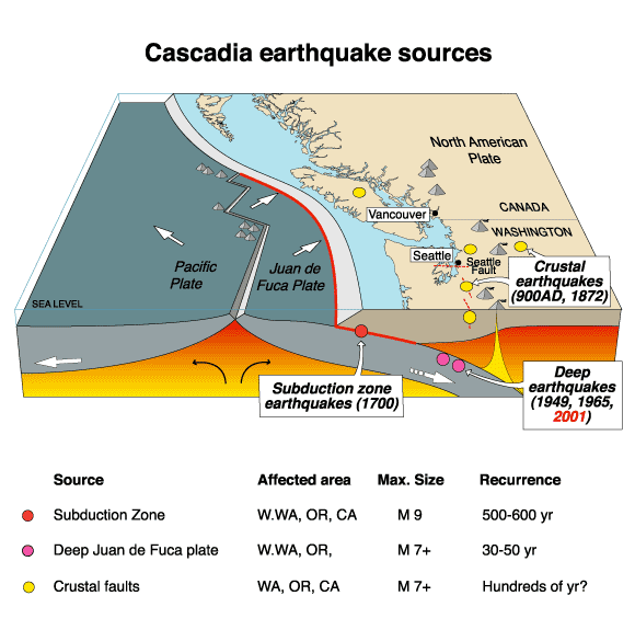
The geological record reveals that great earthquakes with moment magnitude 8 or higher occur in the Cascadia subduction zone about every 500 years on average, often accompanied by tsunamis. There is evidence of at least 13 events at intervals from about 300 to 900 years with an average of 570–590 years.
As seen in the 1700 quake, the 2004 Indian Ocean earthquake, and the 2011 Tōhoku earthquake and tsunami, subduction zone earthquakes can cause large tsunamis, and many coastal areas in the region have prepared tsunami evacuation plans in anticipation of a possible future Cascadia earthquake. However, the major nearby cities, notably Seattle, Portland, Vancouver, Victoria, and Tacoma might be sheltered from the full brunt of a tsunami. These cities do have many vulnerable structures, especially bridges and unreinforced brick buildings; consequently, most of the damage to the cities would probably be from the earthquake itself. One expert asserts that buildings in Seattle are inadequate even to withstand an event of the size of the magnitude 7.9 1906 San Francisco earthquake, let alone a more powerful one.
Kenneth Murphy, who directs FEMA's Region X, the division responsible for Oregon, Washington, Idaho, and Alaska, stated, "Our operating assumption is that everything west of Interstate 5 will be toast."
Recent findings conclude that the Cascadia subduction zone is more complex and volatile than previously believed. In 2010, geologists predicted a 37% chance of a magnitude 8.2+ event within 50 years, and a 10% to 15% chance that the entire Cascadia subduction zone will rupture with a magnitude 9+ event within the same time frame. Geologists have also determined the Pacific Northwest is not prepared for such an earthquake. The tsunami produced could reach heights of 80 to.
A 2004 study revealed the potential for relative mean sea level rise (caused by subsidence of coastal land) along the Cascadia subduction zone. It postulated that cities on the west coast of Vancouver Island, such as Tofino and Ucluelet, are at risk for a 1 to subsidence relative to mean sea level.
The confirmation of their oral traditions about a great earthquake has led many indigenous groups in the area to initiate projects to relocate their coastal communities to higher and safer ground in preparation for the predicted next earthquake. The Huu-ay-aht People have rebuilt their administration building on a high point in their territory; coastal residents are immediately evacuated to this building whenever a tsunami warning is issued, as an interim measure toward eventually relocating all residents to higher ground. The Quileute people secured a land grant from the US government in 2012 to move their settlement inland, both as protection from a future tsunami threat and because of more frequent flooding on the Quillayute River.
In 2023, Washington scientists reported on a detailed study of a high-pressure and high-temperature seafloor seep, likely on the plate boundary, offshore of Oregon. The first seep found on the CSZ, it has been named 'Pythia's Oasis', and may play a role in the regulation of overpressures.
Some other subduction zones have major earthquakes every 100 to 200 years; the longer interval here may indicate unusually large stress buildup and subsequent unusually large earthquake slip.
Bridge of the Gods – Bonneville Slide
It was once conjectured that the Cascadia earthquake may also have been linked to the Bridge of the Gods – Bonneville Slide and the Tseax Cone eruption in British Columbia, Canada. However, 21st-century investigations using radiocarbon dating and dendrochronology date the Bonneville landslide around 1450.
References
References
- {{harvnb. Atwater. Musumi-Rokkaku. Satake. Yoshinobu. 2005
- (2005). "The Orphan Tsunami of 1700 – Japanese Clues to a Parent Earthquake in North America". United States Geological Survey–[[University of Washington Press]].
- (18 January 1996). "Time and size of a giant earthquake in Cascadia inferred from Japanese tsunami records of January 1700". Nature.
- [https://earthquake.usgs.gov/earthquakes/eventpage/official17000127050000000/impact M 9.0 - The 1700 Cascadia Earthquake]
- Schulz, Kathryn. (July 20, 2015). "The Really Big One".
- and pockets of tree stumps that are now under the ocean surface and become exposed only at low tide.[https://www.opb.org/news/series/unprepared/jan-26-1700-how-scientists-know-when-the-last-big-earthquake-happened-here/ "Jan. 26, 1700: How Scientists Know When The Last Big Earthquake Happened Here"]. [[Oregon Public Broadcasting]], January 26, 2015.
- [http://www.amnh.org/explore/science-bulletins/earth/documentaries/tsunami-science-reducing-the-risk/ghosts-of-tsunamis-past "Ghosts of Tsunamis Past"] {{Webarchive. link. (2018-08-28 . [[American Museum of Natural History]].)
- Ruth S. Ludwin. (2005). "Dating the 1700 Cascadia Earthquake: Great Coastal Earthquakes in Native Stories". Seismological Research Letters.
- [https://www.ammsa.com/publications/ravens-eye/prepare-next-tsunami-says-chief "Prepare for next tsunami, says chief"]. ''Raven's Eye'', Vol. 8, No. 9, 2009.
- [[Cowichan Tribes. link. (2015-07-31 . ''[[Indian Country Today Media Network]]'', December 16, 2014.)
- [http://indiancountrytodaymedianetwork.com/2012/11/06/haida-gwaii-quake-brings-home-importance-quileute-relocation-legislation-144214 "Haida Gwaii Quake Brings Home the Importance of Quileute Relocation Legislation"] {{Webarchive. link. (2016-08-23 . ''[[Indian Country Today Media Network]]'', November 6, 2012.)
- (October 2003). "Great Cascadia earthquakes and tsunamis of the past 6700 years, Coquille River estuary, southern coastal Oregon". Geological Society of America Bulletin.
- Yanev, Peter. (27 March 2010). "Shake, Rattle, Seattle". The New York Times.
- (August 16, 2016). "A Major Earthquake in the Pacific Northwest Looks Even Likelier". The Atlantic.
- (24 May 2010). "Odds Are 1-In-3 That A Huge Quake Will Hit Northwest in Next 50 Years". [[Oregon State University]].
- [[Oregon State University]]. (May 25, 2010). "Odds are about 1-in-3 that mega-earthquake will hit Pacific Northwest in next 50 years, scientists say". [[ScienceDaily]].
- (2009-04-19). "Perilous Situation". The Oregonian.
- (2004). "Coseismic subsidence in the 1700 great Cascadia earthquake: Coastal estimates versus elastic dislocation models". [[GSA Bulletin]].
- Munro, Margaret. (March 8, 2012). "Monster earthquake threat looms over B.C. coastal communities". [[Vancouver Sun]].
- (2022-08-08). "Coastal Washington tribe creates higher ground by building tsunami tower, first of its type here". Oregon Public Broadcasting.
- (2022-11-02). "Here's Where the U.S. Is Testing a New Response to Rising Seas". The New York Times.
- (10 Apr 2023). "Warm liquid spewing from Oregon seafloor comes from Cascadia fault, could offer clues to earthquake hazards". UW News.
- (25 Jan 2023). "Fluid sources and overpressures within the central Cascadia Subduction Zone revealed by a warm, high-flux seafloor seep". Science Advances.
- "Cascadia Subduction Zone". Pacific Northwest Seismic Network.
- Hill, Richard L.. (2002-05-15). "Great Cascadia Earthquake Penrose Conference". The Oregonian.
- O'Connor, Jim E.. (September 2004). "The Evolving Landscape of the Columbia River Gorge: Lewis and Clark and Cataclysms on the Columbia". Oregon Historical Quarterly.
- Pringle, Patrick T.. (2009). "The Bonneville slide". Columbia Gorge Interpretive Center Museum Explorations.
- (c. 2015). "10,000 years of Cascadia earthquakes". [[The Oregonian]].
- National Geophysical Data Center / World Data Service (NGDC/WDS). (1972). "Significant Earthquake Information". [[National Geophysical Data Center]], [[National Oceanic and Atmospheric Administration.
This article was imported from Wikipedia and is available under the Creative Commons Attribution-ShareAlike 4.0 License. Content has been adapted to SurfDoc format. Original contributors can be found on the article history page.
Ask Mako anything about 1700 Cascadia earthquake — get instant answers, deeper analysis, and related topics.
Research with MakoFree with your Surf account
Create a free account to save articles, ask Mako questions, and organize your research.
Sign up freeThis content may have been generated or modified by AI. CloudSurf Software LLC is not responsible for the accuracy, completeness, or reliability of AI-generated content. Always verify important information from primary sources.
Report