Kill Van Kull
Tidal strait between New York and New Jersey
title: "Kill Van Kull" type: doc version: 1 created: 2026-02-28 author: "Wikipedia contributors" status: active scope: public tags: ["bayonne,-new-jersey", "new-netherland", "straits-of-new-jersey", "straits-of-richmond-county,-new-york", "bodies-of-water-of-staten-island", "bodies-of-water-of-hudson-county,-new-jersey", "borders-of-new-york-(state)", "borders-of-new-jersey", "port-of-new-york-and-new-jersey"] description: "Tidal strait between New York and New Jersey" topic_path: "general/bayonne-new-jersey" source: "https://en.wikipedia.org/wiki/Kill_Van_Kull" license: "CC BY-SA 4.0" wikipedia_page_id: 0 wikipedia_revision_id: 0
::summary Tidal strait between New York and New Jersey ::
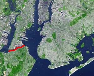
::figure[src="https://upload.wikimedia.org/wikipedia/commons/1/16/Wpdms_terra_killvankull.jpg" caption="The Kill Van Kull (in red) connects [[Newark Bay]] and [[Upper New York Bay"] ::
::figure[src="https://upload.wikimedia.org/wikipedia/commons/c/cd/Kill-Van-Kull-map.svg" caption="Map of [[New York Harbor]] showing the location of the Kill Van Kull"] ::
NOTOC The Kill Van Kull is a tidal strait between Staten Island, New York, and Bayonne, New Jersey, in the United States. It is approximately 3 mi long and 1000 ft wide and connects Newark Bay with Upper New York Bay. The Robbins Reef Light is at the eastern end of the Kill, and Bergen Point marks its western end. It is spanned by the Bayonne Bridge and is one of the most heavily traveled waterways in the Port of New York and New Jersey.
Historically, it has been one of the most important channels for the commerce of the region, providing a passage for marine traffic between Upper New York Bay and the industrial towns of northeastern New Jersey. During the colonial era, it played a significant role in travel between New York and the southern colonies, with passengers changing from ferries to coaches at Elizabethtown (now Elizabeth).
Since the final third of the 20th century, it has provided the principal access for oceangoing container ships to Port Newark-Elizabeth Marine Terminal, the busiest port facility in the eastern United States, and Howland Hook Marine Terminal. The strait has required continued dredging and deepening to accommodate the passage of ever-larger ships. In many areas, the sandy bottom was excavated down to rock and required blasting. The Bayonne Bridge's deck was raised in 2017 so that New Panamax ships could travel the Kill Van Kull.
Collins Park in Bayonne is situated along the northern shore.
Etymology
Kill Van Kull translates as "channel of the ridge" or "pass". Nearby is the Arthur Kill, the name of which is an Anglicization of the Dutch achter kill meaning "back channel", referring to its location "behind" Staten Island.
The name "Kill Van Kull" originated during the early 17th century, during the Dutch colonial era, when the region was part of New Netherland. Places were named by early explorers and settlers in reference to their shape, topography, or other geographic qualities. The area around Newark Bay was termed Achter Col. The bay lies behind Bergen Hill, the ridge of the Hudson Palisades which begins on Bergen Neck, the peninsula between it and the Upper New York Bay. Behind or achter the ridge was a col or mountain pass to the interior.
Kill comes from the Middle Dutch word kille meaning creek. Compare Dordtse Kil in the Netherlands. The bay was known as Cull Bay during the British colonial era.
Gallery
Kill Van Kull BB high jeh.JPG|Western part of the Kill from the Bayonne Bridge Deepening the Kill Van Kull channel.jpg|USACE dredge brings up blasted bedrock in widening the channel. Pilot Boat NYC Harbor.jpg|Ships in Upper New York Bay wait to enter the Kill. Kill Van Kull from new Bayonne Br jeh.jpg|Eastern part of Kill Van Kull
References
- Water upgrade for Kill Van Kull, Staten Island Advance, May 20, 2010
- New York Daily News articles re: Kill Van Kull
|structure = Bridges |place = Newark Bay |bridge = Lehigh Valley Railroad Bridge'''
'''Newark Bay Bridge |bridge signs = [[Image:I-78.svg|20px]]
CRRNJ Newark Bay Bridge (demolished) |upstream =
Newark and New York Railroad Bridge (Hackensack River & Passaic River) (demolished)
Lincoln Highway (Hackensack River & Passaic River) [[Image:US 1-9 Truck.svg|20px]] |downstream =
Arthur Kill Vertical Lift Bridge (Arthur Kill)
Bayonne Bridge (Kill Van Kull) [[Image:NY-440.svg|25px]] [[Image:Ellipse sign 440.svg|25px]] |downstream signs =
References
- (2008). "Hudson County New Jersey Street Map". Hagstrom Map Company, Inc.
- [https://regulations.vlex.com/vid/ports-waterways-kill-van-kull-channel-23361488 Ports and waterways safety: Kill Van Kull Channel et al., NY and NJ], Federal Register, April 15, 1999 (Nbr. Vol. 64, No. 72)
- [http://www.house.gov/list/press/ny08_nadler/KillVanKullRedHook041906.html ''Nadler: Kill Van Kull Fiasco Shows Red Hook’s Importance''] {{webarchive. link. (October 9, 2009 , Congressional Press Release)
- [http://www.nan.usace.army.mil/harbor/kvkf/kvklinks/9905kvkschd.pdf ''Kill Van Kull & Newark Bay Channel Deepening''] {{webarchive. link. (July 14, 2009 , Port Authority of New York and New Jersey, 30. April 1999)
- [http://www.statenislandusa.com/2005/BlastingKillVanKull.html ''Corps Announces Start of Test Blasting Work for Kill Van Kull 50 Foot Deepening''] {{webarchive. link. (November 29, 2010 , U. S. Army Corps Of Engineers, Media Advisory, August 1, 2005)
- Shawn Boburg. [http://newyork.construction.com/yb/ny/article.aspx?story_id=174989298 $1B Bayonne Bridge Renovation Six Months Ahead of Schedule], Bergen County Record, July 19, 2012.
- "Historical marker of Achter Col "colony"". Historical Marker Database.
- Grabas, Joseph A.. "Land Speculation and Proprietary Beginnings of New Jersey". New Jersey Land Title Association.
::callout[type=info title="Wikipedia Source"] This article was imported from Wikipedia and is available under the Creative Commons Attribution-ShareAlike 4.0 License. Content has been adapted to SurfDoc format. Original contributors can be found on the article history page. ::