Kelsey, Alberta
Canadian hamlet, founded 1902
title: "Kelsey, Alberta" type: doc version: 1 created: 2026-02-28 author: "Wikipedia contributors" status: active scope: public tags: ["camrose-county", "hamlets-in-alberta", "designated-places-in-alberta"] description: "Canadian hamlet, founded 1902" topic_path: "general/camrose-county" source: "https://en.wikipedia.org/wiki/Kelsey,_Alberta" license: "CC BY-SA 4.0" wikipedia_page_id: 0 wikipedia_revision_id: 0
::summary Canadian hamlet, founded 1902 ::
::data[format=table title="Infobox settlement"]
| Field | Value |
|---|---|
| name | Kelsey |
| settlement_type | Hamlet |
| image_skyline | Kelsey station.jpg |
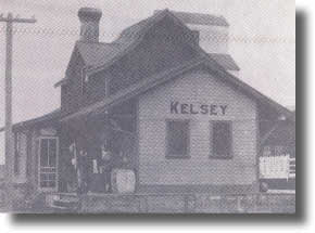
| image_caption | Kelsey Station |
| pushpin_relief | yes |
| pushpin_map | Canada Alberta#Canada |
| pushpin_label_position | |
| pushpin_map_caption | Location of Kelsey |
| subdivision_type | Country |
| subdivision_name | Canada |
| subdivision_type1 | Province |
| subdivision_name1 | Alberta |
| subdivision_type2 | Region |
| subdivision_name2 | Central Alberta |
| subdivision_type3 | Census division |
| subdivision_name3 | 10 |
| subdivision_type4 | Municipal district |
| subdivision_name4 | Camrose County |
| government_type | Unincorporated |
| leader_title1 | Governing body |
| leader_name1 | Camrose County Council |
| established_title | Established |
| established_date | 1902 |
| area_footnotes | (2021) |
| area_land_km2 | 0.45 |
| population_as_of | 2021 |
| population_footnotes | |
| population_total | 15 |
| population_density_km2 | 33.1 |
| timezone | MST |
| utc_offset | −07:00 |
| timezone_DST | MDT |
| utc_offset_DST | −06:00 |
| coordinates | |
| postal_code_type | Postal code |
| postal_code | |
| area_codes | 780, 587, 825 |
| blank_name | Highways |
| blank1_name | Waterways |
| :: |
|name = Kelsey |other_name = |native_name = |nickname = |settlement_type = Hamlet |image_skyline = Kelsey station.jpg |imagesize = |image_caption = Kelsey Station |pushpin_relief = yes |pushpin_map = Canada Alberta#Canada |pushpin_label_position = |pushpin_map_caption = Location of Kelsey |subdivision_type = Country |subdivision_name = Canada |subdivision_type1 = Province |subdivision_name1 = Alberta |subdivision_type2 = Region |subdivision_name2 = Central Alberta |subdivision_type3 = Census division |subdivision_name3 = 10 |subdivision_type4 = Municipal district |subdivision_name4 = Camrose County |government_footnotes = |government_type = Unincorporated |leader_title = |leader_name = |leader_title1 = Governing body |leader_name1 = Camrose County Council |established_title = Established |established_date = 1902 |established_title2 = |established_date2 = |established_title3 = |established_date3 = | area_footnotes = (2021) | area_land_km2 = 0.45 | population_as_of = 2021 | population_footnotes = | population_note = | population_total = 15 | population_density_km2 = 33.1 | population_blank1_title = | population_blank1 = |timezone = MST |utc_offset = −07:00 |timezone_DST = MDT |utc_offset_DST = −06:00 |coordinates = |elevation_footnotes = |elevation_m = |postal_code_type = Postal code |postal_code = |area_codes = 780, 587, 825 |blank_name = Highways |blank_info = |blank1_name = Waterways |blank1_info = |footnotes =
Kelsey is a hamlet in central Alberta, Canada within Camrose County. It is located off Highway 850, approximately 125 km southeast of Edmonton and 30 km southeast of Camrose, Kelsey's closest major trading centre.
Kelsey is home to several local businesses, a community hall, and a post office. Both school and fire services are provided by the nearby villages of Rosalind and Bawlf.
History
In 1902, Mr. and Mrs. Moses Kelsey and their son Earl, arrived in the area from Milbank, South Dakota, and filed on the S.E. 4–45–18. The southeast corner of this quarter of land was later chosen as the site for the community. Milton Zimmerman settled in the area in the same year and suggested the community be named after Kelsey.
In 1915, the Canadian National Railway began laying steel in a south-easterly direction from Camrose. It passed through what a few weeks later became the town of Kelsey. This stretch of railroad is noted for being the longest stretch of straight railway in North America... "if not in the world," some people add.
In 1916, a station house was built in Kelsey and Charlie Cooper, with his wife Anne and family, took up residence in it. The first grain elevator, and two stores were also constructed in the growing town.
By 1920 telephone service had been installed in the Kelsey district and the next few years saw the Kelsey Union Church, a dance hall, and a one-room school.
The first power line to reach Kelsey was constructed in 1951.
Demographics
In the 2021 Census of Population conducted by Statistics Canada, Kelsey had a population of 15 living in 8 of its 9 total private dwellings, a change of from its 2016 population of 15. With a land area of 0.45 km2, it had a population density of in 2021.
As a designated place in the 2016 Census of Population conducted by Statistics Canada, Kelsey had a population of 15 living in 7 of its 7 total private dwellings, a change of from its 2011 population of 15. With a land area of 0.45 km2, it had a population density of in 2016.
References
| Northwest = Ohaton | North = Round Hill | Northeast = Bawlf | West = New Norway | Centre = Kelsey | East = Daysland | Southwest = Edberg | South = Donalda | Southeast = Rosalind
References
- {{AltaML
- (1982). "As the Wheels Turn : a history of Rosalind, Kelsey and districts". Rosalind and District History Book Committee.
- (February 9, 2022). "Population and dwelling counts: Canada and designated places". [[Statistics Canada]].
- (February 8, 2017). "Population and dwelling counts, for Canada, provinces and territories, and designated places, 2016 and 2011 censuses – 100% data (Alberta)". [[Statistics Canada]].
::callout[type=info title="Wikipedia Source"] This article was imported from Wikipedia and is available under the Creative Commons Attribution-ShareAlike 4.0 License. Content has been adapted to SurfDoc format. Original contributors can be found on the article history page. ::