From Surf Wiki (app.surf) — the open knowledge base
Belém
Capital and largest city of Pará, Brazil
Capital and largest city of Pará, Brazil
| Field | Value | ||||||
|---|---|---|---|---|---|---|---|
| name | Belém | ||||||
| official_name | Municipality of Belém | ||||||
| settlement_type | Municipality | ||||||
| image_skyline | {{multiple image | ||||||
| border | infobox | ||||||
| perrow | 1/3/2/1 | ||||||
| total_width | 300 | ||||||
| caption_align | center | ||||||
| image1 | L1010748-L1010765 copie (cropped).jpg | ||||||
| caption1 | Panoramic of the Republic Square in Downtown | ||||||
| image2 | Igreja da Sé - Belém-PA - panoramio.jpg | ||||||
| caption2 | Our Lady of Grace Cathedral | ||||||
| image3 | Belém_Praça_do_Relógio_Clock_Place_01_(cropped).jpg | ||||||
| caption3 | Siqueira Campos Square | ||||||
| image4 | Pórtico_do_Forte_do_Castelo.jpg | ||||||
| caption4 | Forte do Presépio | ||||||
| image5 | Ver-oPeso-Belem.jpg | ||||||
| caption5 | Ver-o-Peso Market | ||||||
| image6 | Teatro_da_Paz_3.jpg | ||||||
| caption6 | Peace Theater | ||||||
| image8 | Captura_de_Tela_2015-05-09_às_17.08.10.png | ||||||
| caption8 | View of the city from Guajará Bay | ||||||
| color | white | ||||||
| image_flag | Bandeira_de_Belém.svg | ||||||
| image_shield | Brasão de Belém do Pará.png | ||||||
| nicknames | "City of Mango Trees", "Metropolis of Amazon". | ||||||
| motto | *Os Estados do Norte estão conosco e nos seguem* | ||||||
| (Northern states are with us and follow us) | |||||||
| image_map | Brazil Para Belem location map.svg | ||||||
| mapsize | 250px | ||||||
| map_caption | Location of Belém in the State of Pará | ||||||
| pushpin_map | Brazil | ||||||
| pushpin_mapsize | 250 | ||||||
| pushpin_map_caption | Location in Brazil | ||||||
| pushpin_relief | yes | ||||||
| pushpin_label_position | top | ||||||
| coordinates | |||||||
| subdivision_type | Country | ||||||
| subdivision_name | Brazil | ||||||
| subdivision_type1 | Region | ||||||
| subdivision_type2 | State | ||||||
| subdivision_name1 | North | ||||||
| subdivision_name2 | Pará | ||||||
| established_title | Founded | ||||||
| established_date | 12 January 1616 | ||||||
| established_title2 | |||||||
| established_title3 | |||||||
| leader_title | Mayor | ||||||
| leader_name | Igor Normando | ||||||
| leader_party | MDB | ||||||
| leader_title1 | Vice Mayor | ||||||
| leader_name1 | Edilson Moura (PT) | ||||||
| area_total_km2 | 1059.4 | ||||||
| elevation_m | 10 | ||||||
| population_total | 1,398,531 | ||||||
| population_as_of | 2024 | ||||||
| population_density_km2 | auto | ||||||
| population_rank | 12th in Brazil | ||||||
| population_metro | 2,249,405 | ||||||
| population_density_metro_km2 | auto | ||||||
| population_demonym | Belenense | ||||||
| postal_code_type | Postal code | ||||||
| postal_code | 66000-001 to 66999-999 | ||||||
| area_code_type | Area code | ||||||
| area_code | +55 91 | ||||||
| blank_name | **HDI** (2010) | ||||||
| blank_info | 0.746 – high{{Cite web | title=Archived copy | url=http://www.pnud.org.br/arquivos/ranking-idhm-2010.pdf | archive-url=https://web.archive.org/web/20140708233352/http://www.pnud.org.br/arquivos/ranking-idhm-2010.pdf | archive-date=July 8, 2014 | access-date=August 1, 2013 | publisher=United Nations Development Programme (UNDP) |
| website | |||||||
| <!-- GDP ---------------> | demographics_type1 | GDP (PPP, constant 2015 values) | |||||
| demographics1_title1 | Year | ||||||
| demographics1_info1 | 2023 | ||||||
| demographics1_title2 | Total | ||||||
| demographics1_info2 | $18.4 billion | ||||||
| demographics1_title3 | Per capita | ||||||
| demographics1_info3 | $8,000 | ||||||
| timezone | BRT | ||||||
| utc_offset | -03:00 |
(Northern states are with us and follow us)
Belém (; Portuguese for Bethlehem; initially called Nossa Senhora de Belém do Grão-Pará, in English Our Lady of Bethlehem of Great Pará), often called Belém of Pará, is the capital and largest city of the state of Pará in the north of Brazil. It is the gateway to the Amazon River with a busy port, airport, and bus/coach station. Belém lies approximately 100 km (62.1 miles) upriver from the Atlantic Ocean, on the Pará River, which is part of the greater Amazon River system, separated from the larger part of the Amazon delta by Ilha de Marajó (Marajo Island). With an estimated population of 1,398,531 people — or 2,491,052, considering its metropolitan area — it is the 12th most populous city in Brazil, as well as the 16th by economic relevance. It is the second largest in the North Region, second only to Manaus, in the state of Amazonas.
Founded in 1616 by the Kingdom of Portugal, Belém was the first European colony on the Amazon but did not become part of Brazil until 1775. The newer part of the city has modern buildings and skyscrapers. The colonial portion retains the charm of tree-filled squares, churches and traditional blue tiles. The city has a rich history and architecture from colonial times. Recently, it witnessed a skyscraper boom.
Belém is also known as the Metropolis of the Brazilian Amazon region or the Cidade das Mangueiras (City of Mango Trees) due to the vast number of those trees found in the city. Brazilians often refer to the city as Belém do Pará ("Belém of Pará") rather than just Belém, a reference to an earlier name for the city, Santa Maria de Belém do Grão Pará ("Saint Mary of Bethlehem of Great Pará"), and also to differentiate it from a number of other towns called Belém in Brazil, as well as the city of Bethlehem in the West Bank of Palestine. It is named after Santa Maria de Belém in Lisbon, also better known by its shortened name, Belém.
Belém is served by Belém International Airport, which connects the city with the rest of Brazil and other cities in South America, North America (United States) and Europe (Lisbon). The city is also home to the Federal University of Pará and the State University of Pará.
Etymology
The origin of the word Belém is Celtic and means "I believe" in the Celtic Breton language. Celtic people who became the Iberian people of Ancient Spain arrived in Portugal during the first millennium, BC. Fragments of their culture and language still subsist throughout Portugal, despite Romanization.Celt-Iberian Breton language did influence other place names in the surrounds, including the country name of "Portugal"
Land where Belém was to founded was a district of Lisbon and the naming was a result of religious related construction on that site. Distinction as Belém occurred due to actions of Prince Henry the Navigator. Prince Henry was the son of King John I of England, Governor of the Military order of Christ and nephew of Portugal's King João II. In Lisbon, Prince Henry constructed a Catholic cathedral that he dedicated as Saint Maria, Belém, in 1460 AD.
By 1499, in the same vicinity was establishment of the Hieronymite Convent, which was a Catholic order of Saint Jerome monks. In addition, as a strategic defense initiative for Lisbon, the Belém Tower, conceived by King João II, was realized there by mid-16th century under leadership of King Manuel I. The result of these improvements led to formulation of a district within Lisbon that became known as Belém.
The entomology of word Belém is frequently ascribed to what appears an erroneous definition for "Bethlehem." Often attributed to a Portuguese translation, the word was of Hebrew origin and meant "House of Bread." However, within the Old Testament, in Micah 5:2, exists prophecy that a Messiah would come from "Ephrathah" which was the ancient place name of the land that encompasses the later founded Bethlehem. The Hebrew Orthodox Jewish scripture denotes this place as "Beit-lechem Ephratah" and "Beit-lechem" or, "ha-beeaֽyat-l֣chem," when directly translated from the Hebrew text (ה בֵּֽית־לֶ֣חֶם) which denotes a locale: Bethlehem.
"Belém " (as mentioned), developed as a result of a Catholic church founding within the district of Lisbon. This was a very pious, Catholic dominated culture. The Catholic religion was also notorious for scribes and language translation. It would have, in that time, been considered very unorthodox and sacrilegious to ascribe a word meaning "House of Bread" to Bethlehem, the Holiest of Christian places and a near cardinal sin to create a namesake.
As the name did transcend from Prince Henry's cathedral dedication, "St Maria of Bethlehem" would have been erroneous and in conflict the New Testament of the Catholic Bible, Book of Luke, Chapter 1, verse 26. Saint Maria's origin was of Nazareth in Galilee. Mary gave birth to the Christian Savior in Bethlehem, while traveling thru the area.
Portuguese language similarities to the Hebrew pronunciation "be-lem" would also be curious. The Hebrew word pronounced "be-lem" means "brake." And, the Portuguese language had established words for "House of Bread" which were "Casa do Pão".
Initially the city was called "St. Mary of Bethlehem of Pará" () or "Our Lady of Bethlehem of Greater Pará" (), eventually shortened to Belém do Pará (name given by Philip III of Spain), in reference to Christmas; the day when captain Francisco Caldeira Castelo Branco left from the city of São Luís in 1615 to conquer the lands of Pará.
History
In 1615, Portuguese captain-general Francisco Caldeira Castelo Branco of the captaincy of Bahia commanded a military expedition sent by the Governor General of Brazil to check the trading excursions of foreigners (French, Dutch, English) up the river (Amazon) from the Cabo do Norte in Grão Pará.
On January 12, 1616, he anchored in what is now known as Guajará Bay, formed by the confluence of the Para and Guamá Rivers, called by the Tupinambás, "Guaçu Paraná". Caldeira mistook the bay for the main channel, and thirty leagues (178 km) upstream, he built a wooden fort, covered with straw, which he called "Presépio" (nativity scene), now known as "Forte do Castelo". The colony formed by the fort was given the name Feliz Lusitânia, "Fortunate Lusitania". It was the embryo of the future city of Belém. The fort failed to suppress Dutch and French trading, but did ward off colonization.
Feliz Lusitânia was later called Nossa Senhora de Belém do Grão Pará (Our Lady of Bethlehem of Grao-Para) and Santa Maria de Belém (St. Mary of Bethlehem). Belém was given city status in 1655 and was made capital of the State when Pará state was split off from Maranhão in 1772. The early decades of the 19th century were marked by political instability. Uprisings and internecine strife finally ended in 1836, after considerable loss of life.
The sugar trade in the Belém region was important up to the end of the 17th century. Thereafter the city's economic importance alternately rose and fell. Cattle ranching supplanted sugar until the 18th century, when cultivation of rice, cotton and coffee became profitable. With the settlement of southern Brazil, where such crops could be produced more efficiently, Belém declined again. The city subsequently became the main exporting centre of the Amazon rubber industry, and by 1866 its position was further enhanced by the opening of the Amazon, Tocantins and Tapajós rivers to navigation. The importance of Belém was then somewhat reduced by the development of the Port of Manaus upriver. The rubber era ended after the boom of 1910–12, but Belém continued to be the main commercial centre of northern Brazil and the entrepôt for the Amazon valley.
Geography
The municipality includes the islands of Mosqueiro, fringed by 14 freshwater beaches, and Caratateua which receive a large number of visitors in summertime. In addition to these and also near Belém, is the island of Tatuoca which is the location of one of the seven geophysical stations in the world, and the only station in Latin America.
Climate
Belém has a tropical rainforest climate (Köppen: Af) more subject to the Intertropical Convergence Zone than the maritime trade winds, and with no cyclones, that is a true equatorial climate. In all 12 months of the year, the city on average sees more than 60 mm of rainfall, so the city has no true dry season month. However, Belém features noticeably wetter and drier seasons. The wetter season spans from December through May, while the drier season covers the remaining six months of the year. Like many cities with a tropical rainforest climate, average temperatures vary little throughout the course of the year, generally hovering around 26.5 degrees Celsius. Due to its location in the Amazon, tropical rainforest is the natural vegetation in and around the city.
|Jan record high C = 34.7 |Feb record high C = 34.6 |Mar record high C = 37.3 |Apr record high C = 34.9 |May record high C = 34.9 |Jun record high C = 34.7 |Jul record high C = 34.5 |Aug record high C = 37.2 |Sep record high C = 38.1 |Oct record high C = 35.4 |Nov record high C = 36.4 |Dec record high C = 37.3 |year record high C =
|Jan record low C = 19.4 |Feb record low C = 18.8 |Mar record low C = 19.8 |Apr record low C = 19.2 |May record low C = 19.8 |Jun record low C = 19.8 |Jul record low C = 14.0 |Aug record low C = 18.5 |Sep record low C = 18.8 |Oct record low C = 18.9 |Nov record low C = 18.6 |Dec record low C = 19.0 |year record low C =
| Jan dew point C =24.5 | Feb dew point C =24.5 | Mar dew point C =24.6 | Apr dew point C =24.8 | May dew point C =24.9 | Jun dew point C =24.5 | Jul dew point C =24.2 | Aug dew point C =24.2 | Sep dew point C =24.2 | Oct dew point C =24.3 | Nov dew point C =24.4 | Dec dew point C =24.6
| archive-url = https://web.archive.org/web/20220324043914/https://portal.inmet.gov.br/uploads/normais/Normal-Climatologica-TMAX.xlsx | archive-date = 24 March 2022 | access-date = 25 May 2024}} | archive-url = https://web.archive.org/web/20220324043931/https://portal.inmet.gov.br/uploads/normais/Normal-Climatologica-TMEDSECA.xlsx | archive-date = 24 March 2022 | access-date = 25 May 2024}} | archive-url = https://web.archive.org/web/20220324044001/https://portal.inmet.gov.br/uploads/normais/Normal-Climatologica-TMIN.xlsx | archive-date = 24 March 2022 | access-date = 25 May 2024}} | archive-url = https://web.archive.org/web/20220324043703/https://portal.inmet.gov.br/uploads/normais/Normal-Climatologica-PREC.xlsx | archive-date = 24 March 2022 | access-date = 25 May 2024}} | archive-url = https://web.archive.org/web/20220324044003/https://portal.inmet.gov.br/uploads/normais/Normal-Climatologica-PRENDIAS1.xlsx | archive-date = 24 March 2022 | access-date = 25 May 2024}} | archive-url = https://web.archive.org/web/20220324043838/https://portal.inmet.gov.br/uploads/normais/Normal-Climatologica-UR.xlsx | archive-date = 24 March 2022 | access-date = 25 May 2024}} | archive-url = https://web.archive.org/web/20220324043829/https://portal.inmet.gov.br/uploads/normais/Normal-Climatologica-INSO.xlsx | archive-date = 24 March 2022 | access-date = 25 May 2024}}
Vegetation
The Amazon represents more than half the planet's remaining rainforests and comprises the largest and most species-rich tract of tropical rainforest in the world. Wet tropical forests are the most species-rich biome, and tropical forests in the Americas are consistently more species rich than the wet forests in Africa and Asia. As the largest tract of tropical rainforest in the Americas, the Amazonian rainforests have unparalleled biodiversity. More than one-third of all species in the world live in the Amazon Rainforest.
Economy
Many valuable products now exported from the Amazon by way of Belém are aluminium, iron ore, and other metals, nuts (chiefly Brazil nuts), pineapples, cassava, jute, wood veneers, and hardwoods. Japanese immigration after the 1930s was an important factor in developing jute and black pepper, notably at Tomé-Açu, just south of Belém, and near Santarém. Marajó Island, the largest fluvial island in the world, which lies just across the Rio Pará from Belém, has some livestock grazing. Electricity is provided by the massive Tucuruí Dam, some 300 km southwest of the city on the Tocantins River.
Demographics
According to the IBGE of 2018, there were 2,491,052 people residing in the Metropolitan Region of Belém. This region is composed by 7 cities: Belém (1,485.732 people), Ananindeua (525,566 people), Marituba (129,321 people), Benevides (61,689 people), Santa Bárbara do Pará (20,704 people), Santa Izabel do Pará (69,746 people), and Castanhal (198,294 people). In 2012, according to IBGE, the capital city itself had a population density of 1337.2 PD/sqkm. The last PNAD (National Research for Sample of Domiciles) census revealed the following numbers: 806,103 Pardo (Multiracial) people (61.8%), 342,476 White (26.3%), 149,395 Black (11.5%), 3,298 Asian people (0.3%) and 2,069 Amerindian people (0.2%).
According to an autosomal DNA genetic study from 2011, the ancestral composition of the population of Belém is: 68.6% European ancestry, followed by 20.9% Amerindian ancestry and 10.6% African ancestry.
Education
Portuguese is the official national language, and thus the primary language taught in schools. But English and Spanish are part of the official high school curriculum.
Education institutions
- Universidade Federal do Pará (UFPA);
- Universidade do Estado do Pará (UEPA);
- Federal Rural University of Amazonia (UFRA);
- Universidade da Amazônia (UNAMA);
- Centro de Instrução Almirante Brás de Aguiar (CIABA);
- Centro Universitário do Estado do Pará (Cesupa);
- Amazon Valley Academy International School (AVA);
- Escola Superior da Amazônia (UNIESAMAZ);
- Centro Universitário Metropolitano da Amazônia (UNIFAMAZ)
- Instituto Federal de Educação, Ciência e Tecnologia do Pará (IFPA)
Culture
Círio de Nazaré
Main article: Círio De Nazaré
On the second Sunday in October, Pará celebrates the largest religious event in Brazil: the procession of the Círio of Nazaré. This tradition started when a farmer and lumberman called Plácido José de Souza found an image of the Virgin and Child on the edge of the Murucutu creek, where the Basilica of Our Lady of Nazareth of Exile stands today. He decided to take the image home. However, the image would mysteriously go back to the place where it was initially found every time he took it home. So Plácido decided to build a small chapel on the edge of the creek. This episode was regarded as miraculous throughout the region. It attracted hundreds of believers to see the image and pay homage to it.
.jpg)
.jpg)
Since then, the Círio has been celebrated as a long procession lasting around five hours, in which thousands of people follow the statue through the streets of Belém. The Círio festival is regarded as the "Christmas of the Amazon" because everyone is involved in the arrangements to receive the saint. In early September, minor celebrations take place as a spiritual preparation for the Círio, with thousands of images scattered all over the capital and neighboring cities.
In time it became necessary to incorporate new elements into the tradition due to the people's desire to honor their patron saint. On the Saturday morning prior to the Círio procession the statue is taken to the square of Ananindeua, a nearby city, to begin a Road Pilgrimage to the Icoaraci pier for a Mass. The river pilgrimage then begins. It was created to honor the "water men" who regard the Virgin of Nazareth as their patron saint. There is a traditional ship contest to award the most originally decorated boat. When the Sacred Image leaves Icoaraci in a Navy Corvette, it is followed by dozens of boats and ships through the waters of Guajará Bay to the pier of Belém, from where it is escorted all the way to the Gentil Bittencourt School. The subsequent candle-lit procession symbolizes the story of the discovery of the Saint and its return to where it was found. The procession follows the Carriage, to which a huge rope is tied, which is carried by the faithful until the procession arrives at the Sé Cathedral.
During the procession, there is a fireworks show, sponsored by the Stevedores' Union, marking the passage of the Saint until its arrival at the Cathedral. At daybreak of the next day, the faithful start to gather at the Old City, believing that this will bring them closer to the Virgin. At 7 o'clock, the archbishop conducts the image to the carriage as bells toll and fireworks explode. The main procession then goes through the streets of the city to the Architectonic Centre of Nazareth, known for its Sanctuary Square. As it arrives at the square, the image is removed from the carriage for the celebration of a Mass and then lifted so that everybody will be blessed by the patron saint of Pará.
The festivities last 15 days, with religious celebrations, like the Children's Círio, and its procession, held two Sundays after the Círio. The Re-Círio marks the end of the celebrations, with a shorter course back to the Gentil Bittencourt chapel.
Convention and Fair Centre of the Amazon
Built in a 23,000-square-metre area, the Hangar Convention and Fair Center of the Amazon has 12 rooms, ticket offices, baggage keeping, press room, and a food court, distributed in two big buildings with a parking lot for 800 vehicles. Genuine Amazonian trees will soon be planted in the outdoor area. With Hangar, Belém joins the market for national conventions that take place in a different city each time, such as the Brazilian Computer Society Congress. National conventions had not been held in the Northern region previously.
Hangar, whose auditorium has room for 2,160 participants, has some of the best technologies available in the world and is the most modern and functional space for events in the country. According to the Brazilian Association of Convention and Fair Centers (ABRACCEF), there are 17,500 events happening on average throughout the 53 main convention and exhibition centres of Brazil. These activities bring together approximately 28 million participants. Belém has great potential for this type of tourism.
Architecture
The colonial architecture Belém reflects the seventeenth-century architecture of Lisbon in Portugal, which served as the inspiration for the main housing projects of the time, with the frequent use of tile-hung façades. The Italian architect and artist Giuseppe Antonio Landi (1713 - 1791) arrived in Pará in 1753 as part of a technical commission, but was invited to stay by Governor Francisco Xavier de Mendonça Furtado, brother of the powerful Sebastião José de Carvalho e Melo, 1st Marquis of Pombal. Landi redesigned the urban plan of the city of Belém, and designing or modifying nearly all of the buildings of the period.
Neoclassical architecture was introduced to Belém in the 19th century, as part of the larger trend in Brazil, and is also present in buildings such as the Theatro da Paz, built in 1874. The Amazoninian rubber cycle brought great wealth to Belém in the late 19th and early 20th century. The intendent Antônio Lemos introduced numerous modernization projects in the city; the wealth élite of Belém built large town mansion, such as the Bibi Costa Mansion, in the eclectic style, many based on French models and building techniques.
Cuisine
The local Amerindian culture makes use of local ingredients to create the colors and flavors of its cuisine. One such ingredient, a fruit named "Cupuaçu", comes from the Cupuaçu tree, found in the Amazonian forest. Cupuaçu is easily identified by its unique smell and sour taste. Its pulp is also extracted to make juices, candies, jellies, liquors, and ice cream. Açaí is a palm tree with a long, thin stem. The palm fruits from this tree are purple in color with a earthy and fruity taste. Long prized by the local population, it recently it has also reached the national menu.
Belém has been part of the UNESCO Creative Cities Network in the category of gastronomy since 2015.
World Social Forum
The World Social Forum 2009 took place from January 27 to February 1 in Belém.
Sports
The three main football teams in Pará are based in Belém: Paysandu, Remo and Tuna Luso. Paysandu based in São Braz, play at the 16,200 capacity Estádio da Curuzú, the oldest stadium of Pará state; Remo, based in Travessa Antônio Baena, play at the 17,250 capacity Baenão; and Tuna Luso-Brasileira based in Souza play at the much smaller 6,500 Estádio Francisco Vasques. The latter stadium is currently the home of Clube Municipal Ananindeua who represent the very large suburb of Ananindeua.
The Estádio Olímpico do Pará is the biggest in the city and hosts 45,000 spectators, the stadium hosts the Grande Premio Brasil de Atletismo, that is part of the IAAF World Challenge as well as Sport Club Belém and the aforementioned teams for large matches.
União Esportiva used to be a relatively successful club based in the city but was disbanded in 1965.
Tourism
Main article: Culture and tourism in Belém (Pará)
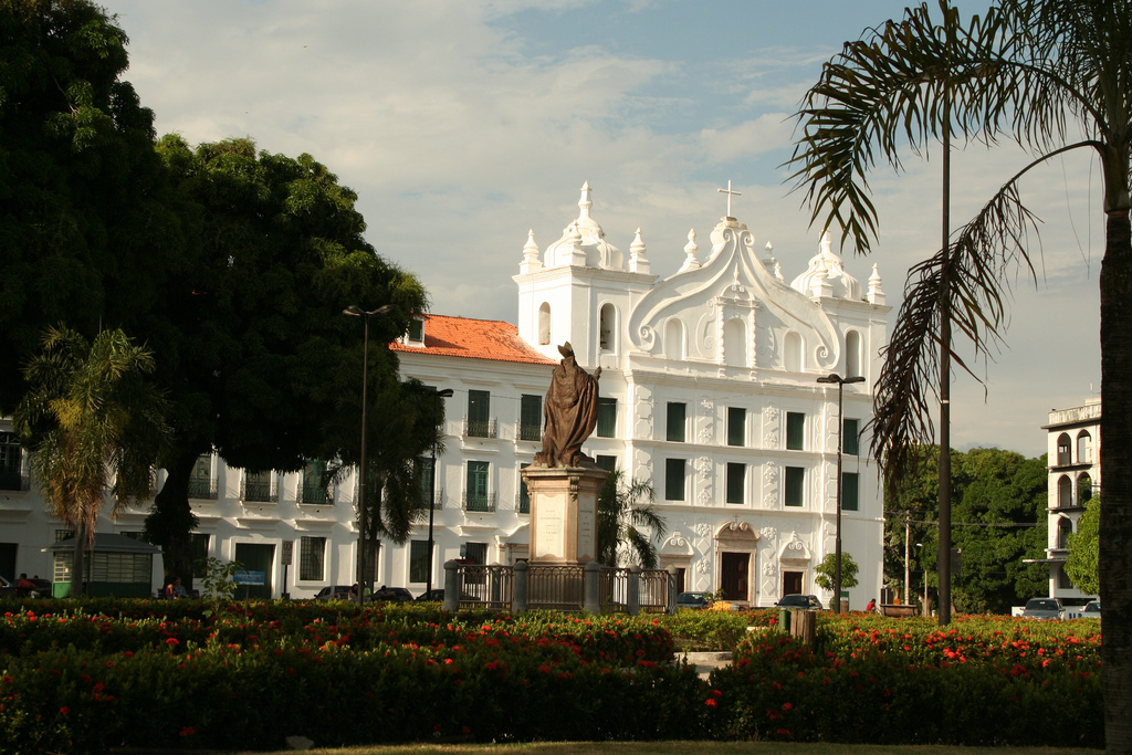
Belém has a modern appearance with tree-lined streets, several plazas and public gardens, and many noteworthy buildings. The north's leading educational and cultural centre, it is the seat of a bishopric, and its cathedral (Igreja da Sé, founded in 1917) is one of Brazil's largest. Santo Alexandre, the oldest of Belém's churches, was built in 1616. The Museu (museum) Paraense Emílio Goeldi, the Teatro da Paz (a classical theatre), and the public library and archives are other notable institutions. The Universidade Federal do Pará (1957), a teacher-training school, an agricultural institute, and an institute for research on tropical diseases are also in the city. The Ver-o-Peso (Portuguese: "see the weight") market in the old port centre is a major tourist attraction. The city is also home to a large football stadium, the Estádio Olímpico do Pará.
Utinga State Park
The municipality of Belém contains 99% of the Utinga State Park, created in 1993 to protect the metropolitan area's water supply. The park provides a space for healthy activities in contact with nature by local people, visitors or tourists. It is just a few kilometers from the city center. There are eight trails, all providing direct contact with various species of flora and fauna. The most popular is the monkey trail, which takes about 40 minutes and goes from Bolonha lake to the visitor center, where other activities are available. Visitors can also learn about the water treatment plant that supplies Belém.

Amazon Biopark Zoo
Located less than 15 km from the center of Belém, in the Tenoné neighborhood, the Bioparque Amazônia Safari – Crocodilo Safari Zoo, is surrounded by forests, rivers and streams. Summary of the Amazon landscape with lush flora and fauna, the zoo has about 14 mi of trails in an area composed of four interconnected ecosystems.
The Museum of Paleontology and Malacology had a collection of three thousand pieces of exposed shells and mollusks collected from all continents.
Bioparque The Amazon is a private investment, owner Jorge Arthur Aarão Monteiro, authorized and licensed by IBAMA to function as C class zoo, the only category of Pará There are four different species of alligators in a population of thousands of individuals, highlighting açu for alligator, monkeys, anteaters, and the otters, hyacinth macaw, papagaios, tucannos, pacaranas, harpy eagle, among other animals. Also see the city turistic website here.
Rodrigues Alves Wood–Botanical Garden
Inspired by the Bois de Boulogne Park in Paris, the Rodrigues Alves Wood is a little piece of Amazonia preserved in the middle of the city. Comprising 16 hectares, in the ample Avenida Almirante Barroso, one of the city's busiest thoroughfares, having 2,500 native species, an orchidary, lakes, caverns, waterfalls and even a replica of a mountain. There you can see small animals characteristic to the region, such as squirrel monkeys, agoutis and macaws.
The Estação das Docas Complex
Main article: Estação das Docas
The Estação das Docas Complex reopened the windows of Belém to Guajará Bay. The restoration project covers the area of old warehouses of the Pará Docks Company. Constructed from prefabricated metal structures in England and that were built at the beginning of the 20th century in Belém.
.jpg)
There are 18,000 m2 of urbanised area, with coffee bar services, various restaurants, stores, travel agencies, banks, in addition to an auditorium and two memorials: The Porto Memorial and the Fortaleza de São Pedro Nolasco Memorial There is also a fluvial station and extensive external area.
Ver-o-Peso Market
Main article: Ver-o-Peso
Created in 1688, as a result of the Portuguese deciding to levy a tax for everything entering and leaving Amazonia. Despite resembling a large retailer, the mixture of colours, fragrances and objects is very interesting as well as folkloric.
Medicinal herbs, various regional fruits, arts and crafts, domestic utilities, meats, fish and seasonings and spices can be found there. The Market brings together two thousand stalls and traders in every part and is located near to the old Mercado de Ferro (Iron market), on the quays.
Mosqueiro
The river island of Mosqueiro, 67 km north of the heart of the city, attracts beach tourists in the dry season.
Infrastructure
Airports
Belém International Airport is the major airport serving the city of Belém. The building design uses plane curves on its roof to permit light to enter its entire large terminal hall.
The architect Sérgio Parada used adopted multiple-use totems integrated with light projectors, a sound system, air conditioning, and public telephones. Currently Belém International Airport serves 2.7 million passengers a year, in a constructed area of 33,255.17 m2.
Traditionally called Belém Airport, it is responsible for increasing tourism in the Amazon region, as well as for the outflow of products and attracting new investments. The passenger terminal is fully air conditioned on two levels and has "futuristic" architecture, designed to take advantage of natural lighting. People with special needs have individualized service with own equipment at specific locations to facilitate their access. The terminal's interior is decorated with plants native to the Amazon region and is enclosed by a source able to imitate the sound of the rains that fall every day in the region.

There also used to exist a smaller Brig. Protásio de Oliveira Airport (Júlio César), also administrated by Infraero, which was used for general aviation, in January, 1st, 2022 it was taken out of service and the area it occupied is going to be turned into a park, its functions were transferred to the main Belém Airport.
Belém Air Force Base – ALA9, one of their most important bases of the Brazilian Air Force, is located in Belém.
Highways
BR-316 is the major access highway for those coming from the Northeastern Brazil. For visitors from the Southern, Southeastern, and Mid-Eastern Regions, the best route is BR-010, which originates in Brasília in the South, and also PA-150, a route that links Belém to Southern Pará.
Waterways
Belém can be reached by the Tocantins River and Amazonas River and by the Atlantic Ocean.
Railways
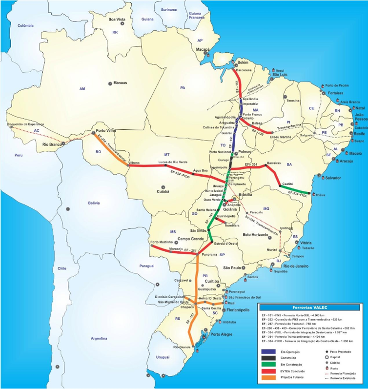
The EF-151 railway, known as "Ferrovia Norte-Sul", literally meaning "North-South Railway", is being extended to run until the city of Barcarena, that is about 111 km away by road. When construction is finished, Barcarena will be linked with important cities, like Imperatriz, Porto Nacional, Anápolis and Panorama.
Distances
- São Paulo: 2933 km
- Rio de Janeiro: 3250 km
- Brasília: 2132 km
- Manaus: 1489 km
- Teresina: 923 km
- São Luís: 806 km
- Santarém, Pará: 807 km
- Rio Branco: 2135 km
- Florianópolis: 3577 km
- Cuiabá: 2970 km
- Belo Horizonte: 2824 km
People
- Hélio Gracie – martial artist
- Guilherme Paraense — Olympic medalist
- Rogério Ferreira – beach volleyball player, World Champion
- Myke Carvalho — brazilian boxer
- Marcos Gueiros — Brazilian racing driver, three-time champion of the Formula 3
- Beto Gonçalves — footballer
- Dira Paes — actress
- Fafá de Belém — singer
- Yago Pikachu — Brazilian football player
- Giovanni Silva de Oliveira – footballer
- Giuseppe Antonio Landi — architect
- Ismael Nery — painter
- Charles Guerreiro — Brazilian football player
- João Clemente Baena Soares — diplomat
- José Márcio Ayres — conservationist
- Larissa Pacheco — mixed martial artist
- Lyoto Machida — mixed martial artist
- Paulo Henrique Chagas de Lima — footballer
- Caroline Ribeiro — model
- Priscilla Meirelles — beauty queen
- Paulo Vítor — Brazilian football player
- Carlos Gracie — Brazilian martial artist
- Waldemar Henrique — composer
- Rosamaria Murtinho — actress
- Rossevelt Bala — heavy metal singer
- Victória Pitts – mezzo-soprano
Government
Subdivisions
Based on Municipal Law nº 8.655 of 30 July 2008, the municipality is divided in 8 Administrative Districts and 71 Neightborhoods:
| Administrative Districts | Number of Neighborhoods | Neighborhoods | TOTAL | 71 | |
|---|---|---|---|---|---|
| [[File:Administrative Districts and Neighborhoods of the City of Belém.png | 250px]] | ||||
| Center (DABEL) | 8 | Batista Campos • Campina • Cidade Velha • Marco • Nazaré • Reduto • São Brás • Umarizal | |||
| Benguí (DABEN) | 8 | Benguí • Cabanagem • Coqueiro • Parque Verde • Pratinha • São Clemente • Tapanã • Una | |||
| Entroncamento (DAENT) | 10 | Águas Lindas • Aurá • Castanheira • Curió-Utinga • Guanabara • Mangueirão • Marambaia • Souza • Universitário • Val-de-Cans | |||
| Guamá (DAGUA) | 6 | Canudos • Condor • Cremação • Guamá • Jurunas • Montese (Terra Firme) | |||
| Icoaraci (DAICO) | 9 | Águas Negras • Agulha • Campina de Icoaraci • Cruzeiro • Maracacueira • Paracuri • Parque Guajará • Ponta Grossa • Tenoné | |||
| Mosqueiro (DAMOS) | 19 | Aeroporto • Ariramba • Baía do Sol • Bomfim • Carananduba • Caruará • Chapéu Virado • Farol • Mangueiras • Maracajá • Marahú • Murubira • Natal do Murubira • Paraíso • Porto Arthur • Praia Grande • São Francisco • Sucurijuquara • Vila | |||
| Outeiro (DAOUT) | 4 | Água Boa • Brasília • Itaiteua • São João do Outeiro | |||
| Sacramenta (DASAC) | 7 | Barreiro • Fátima • Maracangalha • Miramar • Pedreira • Sacramenta • Telegráfo |
Consular representations
The following countries have consular representations in Belém:
- Japan (Consulate)
- Portugal (Vice-Consulate)
- Suriname (Consulate-General)
International Relations
Belém has the following partnership cities:
References
References
- [https://cidades.ibge.gov.br/brasil/pa/belem/panorama IBGE 2020]
- "TelluBase—Brazil Fact Sheet (Tellusant Public Service Series)". Tellusant.
- (2016). "Capitais brasileiras: dados históricos, demográficos, culturais e midiáticos". Appris Editora.
- Chavses, Celma. (2013). "The public market in Belem: architecture and urban insertion". IV International Colloquium on Trade and City – CINCCI.
- "Portugal - Etymology, Origin & Meaning of the Name".
- Pearce, William C.. (1878). "History of Spain and Portugal. With ... Map and Illustrations". Lovell.
- Cross, Wilbur Lucius. (1918). "The History of Henry Fielding". Yale University Press.
- "500 Years of History".
- "Bible Gateway passage: Michoh 5:2 - Orthodox Jewish Bible".
- "Bible Gateway passage: Luke 1:26-38 - New International Version".
- "Google Translate".
- "Google Translate".
- (2016). "Capitais brasileiras: dados históricos, demográficos, culturais e midiáticos". Appris.
- (2012). "Brasil, Pará, Belém, História". Instituto Brasileiro de Geografia e Estatística.
- (2013-03-28). "O mercado público em Belém: arquitetura e inserção urbanística". Faculdade de Arquitetura e Urbanismo da Universidade de São Paulo.
- Pereira, Carlos Simões. (2020-10-28). "Das origens da Belém seiscentista e sua herança Tupinambá". Revista Científica Multidisciplinar Núcleo do Conhecimento.
- "Capitania do Grão-Pará". Atlas Digital da América Lusa.
- "History of Belém".
- "Rubber era in Belém".
- "Clima".
- (July 2012). "Condições termodinâmicas de eventos de precipitação extrema em Belém-PA durante a estação chuvosa". Revista Brasileira de Meteorologia.
- "Temperatura Máxima Absoluta (°C)". Brazilian National Institute of Meteorology (Inmet).
- (February 2017). "Temperatura Mínima Absoluta (°C)". Brazilian National Institute of Meteorology (Inmet).
- "World Meteorological Organization Climate normals for 1991-2020: Belem". [[NOAA]].
- "Climate and monthly weather forecast Belém, Brazil".
- Turner, I. M. 2001. ''The ecology of trees in the tropical rainforest''. [[Cambridge University Press]], Cambridge. {{ISBN. 0-521-80183-4
- "Amazon Rainforest, Amazon Plants, Amazon River Animals".
- (8 October 2005). "Metals in Belém".
- [http://www.rizoma.ufsc.br/html/1073-of6-st3.htm Japanese Immigration to Pará and Belém] {{webarchive. link. (February 13, 2009)
- "About Marajó Island".
- link. (July 6, 2011)
- "Censo 2022 – Panorama".
- (2011). "The genomic ancestry of individuals from different geographical regions of Brazil is more uniform than expected". PLOS ONE.
- Araujo, Renata Malcher de. (2012). "Belém". Heritage of Portuguese Influence/Património de Influência Portuguesa.
- (2018). "Palacete Bibi Costa". Instituto de História de Arte da FCSH/NOVA.
- "Belém, Salvador and Santos join the UNESCO Creative Cities Network".
- (August 2013). "Plano de Manejo do Parque Estadual do Utinga". Secretaria de Estado de Meio Ambiente (SEMA).
- "Apresentaçao". SEMAS: Secretaria de Estado de Meio Ambiente e Sustentabilidade.
- (27 July 2013). "Parque do Utinga, em Belém, preserva belezas naturais da floresta".
- "Amazon Biopark Zoo (Bioparque Amazônia)".
- "Bioparque Amazônia Safari".
- "Estação das Docas".
- "Ilha de Mosqueiro".
- "International Airport of Belém".
- (2 January 2022). "Ouça a despedida do controlador do aeroporto de Belém que será transformado em parque".
- "111 km – Distância entre Belém – PA e Barcarena – PA".
- "Ferrovia Norte-Sul – VALEC".
- "Traçado Ferrovia Norte Sul".
- (30 July 2008). "Plano Diretor Municipal".
- "Diplomatieke Missies".
- Miyake, Rafael. (2025-11-10). "Belém torna-se cidade irmã do Rio de Janeiro".
This article was imported from Wikipedia and is available under the Creative Commons Attribution-ShareAlike 4.0 License. Content has been adapted to SurfDoc format. Original contributors can be found on the article history page.
Ask Mako anything about Belém — get instant answers, deeper analysis, and related topics.
Research with MakoFree with your Surf account
Create a free account to save articles, ask Mako questions, and organize your research.
Sign up freeThis content may have been generated or modified by AI. CloudSurf Software LLC is not responsible for the accuracy, completeness, or reliability of AI-generated content. Always verify important information from primary sources.
Report