Xinyang
title: "Xinyang" type: doc version: 1 created: 2026-02-28 author: "Wikipedia contributors" status: active scope: public tags: ["xinyang", "cities-in-henan", "prefecture-level-divisions-of-henan", "national-civilized-city"] topic_path: "geography" source: "https://en.wikipedia.org/wiki/Xinyang" license: "CC BY-SA 4.0" wikipedia_page_id: 0 wikipedia_revision_id: 0
::data[format=table title="Infobox settlement"]
| Field | Value |
|---|---|
| name | Xinyang |
| other_name | Sinyang |
| native_name | 信阳市 |
| native_name_lang | zh-Hans |
| settlement_type | Prefecture-level city |
| total_type | |
| image_skyline | Xinyang new district1.png |
| image_caption | View of Xinyang, 2014 |
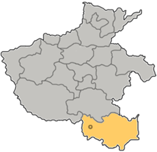
| image_map | Henan Xinyang map a.png |
| map_caption | Location of Xinyang City jurisdiction in Henan |
| pushpin_map | China Northern Plain#China |
| pushpin_map_alt | Xinyang is located at the southern end of the North China Plain, north of the Dabie Mountains |
| pushpin_map_caption | Location on the North China Plain |
| subdivision_type | Country |
| subdivision_name | People's Republic of China |
| subdivision_type1 | Province |
| subdivision_name1 | Henan |
| seat_type | Municipal seat |
| seat | Pingqiao District |
| parts_style | |
| parts | |
| p2 | |
| leader_title1 | |
| established_title | |
| established_title1 | |
| established_title2 | |
| area_magnitude | |
| unit_pref | |
| area_urban_footnotes | |
| area_footnotes | {{cite web |
| url | https://www.hongheiku.com/xianjirank/ |
| script-title | zh:最新人口信息 |
| publisher | hongheiku |
| language | zh |
| access-date | 2021-01-12}} |
| area_total_km2 | 18819 |
| area_land_km2 | |
| area_urban_km2 | 3865.9 |
| area_metro_km2 | 3665.9 |
| elevation_footnotes | tags-- |
| population_as_of | 2020 Census for total, 2018 otherwise |
| population_footnotes | |
| population_total | 6234401 |
| population_density_km2 | auto |
| population_metro | 1416800 |
| population_density_metro_km2 | auto |
| population_urban | 1416800 |
| population_density_urban_km2 | auto |
| demographics_type2 | GDP |
| demographics2_title1 | Prefecture-level city |
| demographics2_info1 | CN¥ 203.8 billion |
| US$ 30.7 billion | |
| demographics2_title2 | Per capita |
| demographics2_info2 | CN¥ 31,733 |
| US$ 4,777 | |
| timezone | China Standard |
| utc_offset | +8 |
| coor_pinpoint | Xinyang municipal government |
| coordinates | |
| postal_code_type | Postal code |
| area_code | 0376 |
| iso_code | CN-HA-15 |
| blank1_name | Major Nationalities |
| blank1_info | Han |
| blank2_name | License plate prefixes |
| blank2_info | {{linktext |
| website | |
| :: |
|name = Xinyang
|official_name =
|other_name = Sinyang
|native_name = 信阳市
|native_name_lang = zh-Hans
|nickname =
|settlement_type = Prefecture-level city
|total_type =
|image_skyline = Xinyang new district1.png
|image_caption = View of Xinyang, 2014
|image_map = Henan Xinyang map a.png
|mapsize =
|map_caption = Location of Xinyang City jurisdiction in Henan
|pushpin_map = China Northern Plain#China
|pushpin_map_alt = Xinyang is located at the southern end of the North China Plain, north of the Dabie Mountains
|pushpin_label_position =
|pushpin_map_caption = Location on the North China Plain
|pushpin_mapsize =
|subdivision_type = Country
|subdivision_name = People's Republic of China
|subdivision_type1 = Province
|subdivision_name1 = Henan
|subdivision_type2 =
|subdivision_name2 =
|seat_type = Municipal seat
|seat = Pingqiao District
|parts_type =
|parts_style =
Default is list if up to 5 items, coll if more than 5--
|parts =
|p1 =
|p2 =
|government_footnotes =
|government_type =
|leader_title =
|leader_name =
|leader_title1 =
|leader_name1 =
|leader_title2 =
|leader_name2 =
|leader_title3 =
|leader_name3 =
|leader_title4 =
|leader_name4 =
|established_title =
|established_date =
|established_title1 =
|established_date1 =
|established_title2 =
|established_date2 =
|established_title3 =
|established_date3 =
|founder =
|named_for =
|area_magnitude =
|unit_pref =
|area_urban_footnotes =
|area_footnotes ={{cite web
|url = https://www.hongheiku.com/xianjirank/
|script-title=zh:最新人口信息
|publisher = hongheiku
|language = zh
|access-date = 2021-01-12}}
|area_total_km2 =18819
|area_land_km2 =
|area_water_km2 =
|area_water_percent =
|area_urban_km2 =3865.9
|area_metro_km2 =3665.9
|area_blank1_title =
|area_blank1_km2 =
|elevation_footnotes = tags--
|elevation_m =
|elevation_ft =
|elevation_max_m =
|elevation_max_ft =
|elevation_min_m =
|elevation_min_ft =
|population_as_of =2020 Census for total, 2018 otherwise
|population_footnotes =
|population_note =
|population_total =6234401
|population_density_km2 =auto
|population_metro =1416800
|population_density_metro_km2 =auto
| population_urban =1416800
|population_density_urban_km2 =auto
|population_blank1_title =
|population_blank1 =
|population_density_blank1_km2 =
| demographics_type2 = GDP
| demographics2_title1 = Prefecture-level city
| demographics2_info1 = CN¥ 203.8 billion
US$ 30.7 billion
| demographics2_title2 = Per capita
| demographics2_info2 = CN¥ 31,733
US$ 4,777
|timezone = China Standard
|utc_offset = +8
|coor_pinpoint = Xinyang municipal government
|coordinates =
|postal_code_type =Postal code
|postal_code =
|area_code =0376
|iso_code = CN-HA-15
|blank1_name =Major Nationalities
|blank1_info =Han
|blank2_name =License plate prefixes
|blank2_info ={{linktext|豫}}S
|blank3_name =
|blank3_info =
|blank4_name =
|blank4_info =
|blank5_name =
|blank5_info =
|blank6_name =
|blank6_info =
|website =
|footnotes =
Xinyang (; postal: Sinyang) is a prefecture-level city in southeastern Henan province, People's Republic of China, the southernmost administrative division in the province. Its total population was 6,234,401 according to the 2020 census. As of the 2010 census, 1,230,042 of them lived in the built-up (or metro) area made of two urban districts, Pingqiao and Shihe.
History
As early as over 8,000 years ago, Neolithic cultures began primitive agriculture of considerable scale along the Huai River, such as the Peiligang, Longshan and Qujialing cultures.
During the Great Leap Forward, one million farmers died in what was known as the Xinyang Incident.
Geography
::figure[src="https://upload.wikimedia.org/wikipedia/commons/5/5c/Txu-oclc-10552568-ni50-13.jpg" caption="AMS]], 1954)"] ::
::figure[src="https://upload.wikimedia.org/wikipedia/commons/f/f4/Jin_lan_mountain_c.png" caption="金兰山国家森林公园}}), [[Xin County"] ::
::figure[src="https://upload.wikimedia.org/wikipedia/commons/a/a4/Xinyang_city3.png" caption="Xinyang panorama, 2014"] ::
Geography of city
The prefecture-level city of Xinyang has a total land area of 18819 km2. The city is located in the southernmost part of Henan Province on the south bank of the Huai River and in the middle of the Dabie Mountains area. It borders the cities Zhumadian to the north and Nanyang to the northwest, and the provinces of Anhui and Hubei to the east and south respectively. The region where Xinyang is located is considered a subtropical area and the Dabie mountainous terrain is mainly to the north, south, and east of the city.
Climate
| Xinyang | -1.3 | 6.8 | 29 | .6 | 9.0 | 42 | 5.0 | 13.9 | 69 | 11.6 | 21.4 | 80 | 16.5 | 25.9 | 126 | 20.7 | 29.5 | 154 | 23.9 | 31.6 | 184 | 23.0 | 30.9 | 160 | 17.8 | 26.6 | 108 | 12.0 | 21.6 | 81 | 5.9 | 15.4 | 51 | .8 | 9.5 | 21 |float=right |clear=none |source = CMA }} --
Xinyang has a monsoon-influenced, four-season distinct humid subtropical climate (Köppen Cfa/Cwa), with cold, damp winters, and hot, humid summers. The months of April through June here are slightly cooler than much of the rest of the province. The monthly 24-hour average temperature ranges from 2.4 °C in January to 27.3 °C in July; the annual mean is 15.54 °C. The annual precipitation is just above 1100 mm, and close to two-thirds of it occurs from May to September. With monthly percent possible sunshine ranging from 38% in March to 47% in four months, the city receives 1,974 hours of bright sunshine annually; January through March are the cloudiest months.
|location = Xinyang, elevation 115 m, (1991–2020 normals, extremes 1951–present) |metric first = y |single line = y |collapsed = Y |Jan high C = 7.0 |Feb high C = 10.4 |Mar high C = 15.9 |Apr high C = 22.3 |May high C = 26.9 |Jun high C = 30.1 |Jul high C = 31.9 |Aug high C = 30.9 |Sep high C = 27.0 |Oct high C = 22.1 |Nov high C = 15.7 |Dec high C = 9.5 |Jan mean C = 2.5 |Feb mean C = 5.5 |Mar mean C = 10.7 |Apr mean C = 16.9 |May mean C = 21.8 |Jun mean C = 25.4 |Jul mean C = 27.7 |Aug mean C = 26.6 |Sep mean C = 22.1 |Oct mean C = 16.7 |Nov mean C = 10.5 |Dec mean C = 4.8 |Jan low C = -0.9 |Feb low C = 1.7 |Mar low C = 6.6 |Apr low C = 12.4 |May low C = 17.5 |Jun low C = 21.5 |Jul low C = 24.4 |Aug low C = 23.3 |Sep low C = 18.4 |Oct low C = 12.8 |Nov low C = 6.7 |Dec low C = 1.3
|Jan record high C = 20.6 |Feb record high C = 26.5 |Mar record high C = 34.3 |Apr record high C = 34.3 |May record high C = 36.3 |Jun record high C = 38.7 |Jul record high C = 40.1 |Aug record high C = 40.9 |Sep record high C = 37.3 |Oct record high C = 34.2 |Nov record high C = 30.0 |Dec record high C = 21.7 |Jan record low C = -20.0 |Feb record low C = -16.0 |Mar record low C = −6.6 |Apr record low C = −0.6 |May record low C = 5.0 |Jun record low C = 11.9 |Jul record low C = 17.0 |Aug record low C = 14.1 |Sep record low C = 7.9 |Oct record low C = −0.4 |Nov record low C = −6.4 |Dec record low C = −12.4 |precipitation colour = green |Jan precipitation mm = 32.3 |Feb precipitation mm = 38.7 |Mar precipitation mm = 64.4 |Apr precipitation mm = 80.3 |May precipitation mm = 111.8 |Jun precipitation mm = 163.7 |Jul precipitation mm = 204.8 |Aug precipitation mm = 154.5 |Sep precipitation mm = 86.5 |Oct precipitation mm = 74.2 |Nov precipitation mm = 47.2 |Dec precipitation mm = 23.9 |Jan humidity = 70 |Feb humidity = 70 |Mar humidity = 67 |Apr humidity = 67 |May humidity = 69 |Jun humidity = 75 |Jul humidity = 79 |Aug humidity = 81 |Sep humidity = 78 |Oct humidity = 74 |Nov humidity = 71 |Dec humidity = 68 |unit precipitation days = 0.1 mm |Jan precipitation days = 6.9 |Feb precipitation days = 8.4 |Mar precipitation days = 9.1 |Apr precipitation days = 9.0 |May precipitation days = 11.0 |Jun precipitation days = 10.2 |Jul precipitation days = 12.0 |Aug precipitation days = 11.6 |Sep precipitation days = 10.2 |Oct precipitation days = 9.4 |Nov precipitation days = 8.1 |Dec precipitation days = 6.2 |year precipitation days = |Jan sun = 106.6 |Feb sun = 108.9 |Mar sun = 143.1 |Apr sun = 167.3 |May sun = 172.6 |Jun sun = 162.4 |Jul sun = 177.1 |Aug sun = 162.5 |Sep sun = 139.0 |Oct sun = 136.5 |Nov sun = 127.9 |Dec sun = 122.2 |year sun = | Jan percentsun = 33 | Feb percentsun = 35 | Mar percentsun = 38 | Apr percentsun = 43 | May percentsun = 40 | Jun percentsun = 38 | Jul percentsun = 41 | Aug percentsun = 40 | Sep percentsun = 38 | Oct percentsun = 39 | Nov percentsun = 41 | Dec percentsun = 39 | year percentsun = |Jan snow days = 5.1 |Feb snow days = 3.6 |Mar snow days = 1.3 |Apr snow days = 0 |May snow days = 0 |Jun snow days = 0 |Jul snow days = 0 |Aug snow days = 0 |Sep snow days = 0 |Oct snow days = 0 |Nov snow days = 0.8 |Dec snow days = 2.3 |year snow days = |source 1 = China Meteorological Administration
Administration
The Xinyang City is further divided into two districts and eight counties.
Xinyang City has 2 districts and 8 counties, including Shihe District, Pingqiao District, Huangchuan County, Guangshan County, Xi County, Xin County, Luoshan County, Shangcheng County, Huaibin County, and Gushi County.
::data[format=table]
| Map | English name | Simplified | Traditional | Pinyin | Area | Population | Density |
|---|---|---|---|---|---|---|---|
| Shihe District | 浉河区 | 浉河區 | zh | 1,782.51 | 594,391 | 333 | |
| Pingqiao District | 平桥区 | 平橋區 | zh | 1,883.42 | 635,651 | 337 | |
| Huangchuan County | 潢川县 | 潢川縣 | zh | 1,638 | 630,333 | 385 | |
| Huaibin County | 淮滨县 | 淮濱縣 | zh | 1,208 | 570,156 | 472 | |
| Xi County | 息县 | 息縣 | zh | 1,835 | 793,746 | 433 | |
| Xin County | 新县 | 新縣 | zh | 1,612 | 275,285 | 171 | |
| Shangcheng County | 商城县 | 商城縣 | zh | 2,130 | 495,491 | 233 | |
| Gushi County | 固始县 | 固始縣 | zh | 2,946 | 1,023,857 | 348 | |
| Luoshan County | 罗山县 | 羅山縣 | zh | 2,065 | 504,542 | 244 | |
| Guangshan County | 光山县 | 光山縣 | zh | 1,835 | 275,282 | 150 | |
| :: |
Demographics
According to the Seventh National Census in 2020, the city's Permanent Population (hukou) was 6,234,401.Compared with 6,108,683 people in the Sixth National Census in 2010, the number increased by 125,718, representing a growth of 2.06%, with an average annual growth rate of 0.20%.
According to the 2010 Census, the population of Xinyang is of 6,109,106 inhabitants, 6.39% less than the population marked on the last census of 2000, when there were 6,527,368 inhabitants in the city.
Its built-up area is home to 1,230,042 inhabitants spread out on 2 urban districts and 3665.9 km².
Culture
::figure[src="https://upload.wikimedia.org/wikipedia/commons/e/e6/Xinyang_guishanting.png" caption="龟山亭}})"] ::
::figure[src="https://upload.wikimedia.org/wikipedia/commons/4/47/Huaihe_museum.png" caption="淮河博物馆}}), [[Huaibin County"] ::
Xinyang Tea Culture Festival is held during April 28 and 30 of every year. The 25,000-capacity Xinyang Stadium, which has a capacity of 25,000, is located in the city. It is used mostly for association football and sometimes for athletics. ::figure[src="https://upload.wikimedia.org/wikipedia/commons/5/5c/Guangshan_Jingju_Temple.jpg" caption="'''Jingju Temple(净居寺)'''"] ::
The Jingju Temple in Guangshan county was the source of the first Chinese section of the Buddhist "Tiantai school" as early as the fifth year of Tianbao in the Northern Qi Dynasty (554 A.D.), since the saint monk Huisi came to the Jingju Temple. Emperor Shenzong of Song bestowed the "Emperor entitled Brahma Temple" still conserved in the temple.
Transportation
- Highway system
- Railway system
- Airport
Education
- Higher Education
- Secondary Education
- Xinyang Senior High School
- Guangshan Second High School
Recreation
Twin towns
References
References
- Cox, W. (2018). "Demographia World Urban Areas. 14th Annual Edition". Demographia.
- "China: Hénán (Prefectures, Cities, Districts and Counties) - Population Statistics, Charts and Map".
- 河南省统计局、国家统计局河南调查总队. (November 2017). "《河南统计年鉴-2017》". [[China Statistics Press]].
- "河南统计年鉴—2017". www.ha.stats.gov.cn.
- (2020-07-04). "信阳事件:一个沉痛的历史教训_资讯_凤凰网".
- link. [[China Meteorological Administration]]
- Fang, Jiawang. (2024-01-25). "信阳市行政区划地图:信阳市辖2个区、8个县分别是哪些?".
- "统计公报 - 信阳市统计局".
- {{in lang. link. (March 25, 2012)
- (2019-11-29). "信阳一古寺,苏轼在此留下千古诗篇,每年有上万人参拜,门票免费_大苏".
- Hui, Ren. (2012-07-26). "河南光山净居寺 — 大菩文化".
::callout[type=info title="Wikipedia Source"] This article was imported from Wikipedia and is available under the Creative Commons Attribution-ShareAlike 4.0 License. Content has been adapted to SurfDoc format. Original contributors can be found on the article history page. ::