Xagħra
title: "Xagħra" type: doc version: 1 created: 2026-02-28 author: "Wikipedia contributors" status: active scope: public tags: ["xagħra", "towns-in-malta", "local-councils-of-malta", "gozo"] topic_path: "general/xaghra" source: "https://en.wikipedia.org/wiki/Xagħra" license: "CC BY-SA 4.0" wikipedia_page_id: 0 wikipedia_revision_id: 0
::data[format=table title="Infobox settlement"]
| Field | Value |
|---|---|
| name | Xagħra |
| native_name | Ix-Xagħra |
| native_name_lang | mt |
| other_name | Caccia, Sciara |
| settlement_type | Local council |
| image_skyline | Malte, Gozo, Xaghra.JPG |
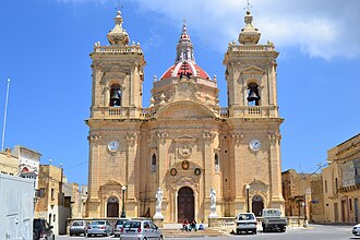
| image_caption | The Basilica of the Nativity of Our Lady |
| image_flag | Flag of Xagħra.svg |
| image_shield | Coat of Arms of Xghara Local Council.svg |
| image_map | Xaghra in Malta.svg |
| map_caption | Xagħra, in Gozo |
| coordinates | |
| subdivision_type | Country |
| subdivision_name | Malta |
| subdivision_type1 | Region |
| subdivision_name1 | Flag of Gozo.svg Gozo Region |
| subdivision_type2 | District |
| subdivision_name2 | Gozo and Comino District |
| parts_type | Borders |
| parts_style | para |
| p1 | Nadur, Victoria, Xewkija, Żebbuġ |
| leader_title | Mayor |
| leader_name | Dr Christian Zammit |
| leader_party | PL |
| unit_pref | Metric |
| area_total_km2 | 7.6 |
| population_total | 4886 |
| population_as_of | March 2014 |
| population_density_km2 | auto |
| population_demonym | Xagħri (m), Xagħrija (f), Xagħrin (pl/n) |
| timezone1 | CET |
| utc_offset1 | +1 |
| timezone1_DST | CEST |
| utc_offset1_DST | +2 |
| postal_code_type | Postal code |
| postal_code | XRA |
| area_code_type | Dialing code |
| area_code | 356 |
| iso_code | MT-61 |
| blank_name_sec1 | Patron saint |
| blank_info_sec1 | Our Lady of Victories |
| blank1_name_sec1 | Day of festa |
| blank1_info_sec1 | 8 September |
| website | Official website |
| :: |
| name = Xagħra | native_name = Ix-Xagħra | native_name_lang = mt | official_name = | other_name = Caccia, Sciara | settlement_type = Local council | image_skyline = Malte, Gozo, Xaghra.JPG | image_caption = The Basilica of the Nativity of Our Lady | image_flag = Flag of Xagħra.svg | image_shield = Coat of Arms of Xghara Local Council.svg | etymology = | nickname = | motto = | image_map = Xaghra in Malta.svg | map_caption = Xagħra, in Gozo | coordinates = | coordinates_footnotes = | subdivision_type = Country | subdivision_name = Malta | subdivision_type1 = Region | subdivision_name1 = Flag of Gozo.svg Gozo Region | subdivision_type2 = District | subdivision_name2 = Gozo and Comino District | established_title = | established_date = | founder = | parts_type = Borders | parts_style = para | p1 = Nadur, Victoria, Xewkija, Żebbuġ | leader_title = Mayor | leader_name = Dr Christian Zammit | leader_party = PL | unit_pref = Metric | area_total_km2 = 7.6 | area_note = | area_footnotes = | elevation_m = | elevation_footnotes = | population_total = 4886 | population_as_of = March 2014 | population_footnotes = | population_density_km2 = auto | population_note = | population_demonym = Xagħri (m), Xagħrija (f), Xagħrin (pl/n) | timezone1 = CET | utc_offset1 = +1 | timezone1_DST = CEST | utc_offset1_DST = +2 | postal_code_type = Postal code | postal_code = XRA | area_code_type = Dialing code | area_code = 356 | iso_code = MT-61 | blank_name_sec1 = Patron saint | blank_info_sec1 = Our Lady of Victories | blank1_name_sec1 = Day of festa | blank1_info_sec1 = 8 September | website = Official website | footnotes =
Xagħra () is an administrative unit of Malta on the island of Gozo. It is one of the earliest inhabited parts of Gozo, being home to the Ġgantija megalithic temples, which date back to 3600 BC, and the Xagħra Stone Circle. Natural underground features such as Xerri's Grotto and Ninu's Cave are located in this town, along with Calypso's Cave, which overlooks the red sandy beach of Ramla Bay. It is the second-largest town in Gozo, with a population of 5,161 according to the 2021 census, and it is located northeast of Victoria, the capital of Gozo.
Xagħra is a popular tourist destination due to its historical heritage and lively Victory Square. Thousands of visitors flock to Ramla Bay in summer and to the temples all year round.
During the British period, Xagħra was also known as Casal Caccia.
Twin towns – sister cities
Xagħra is twinned with:
- Offida, Italy
Notable people born here
- Sarah Bonnici - pop singer, dancer
References
References
- (1999). "The Postal History of Malta". Proud-Bailey Co. Ltd.
- "Twinning". Government of Malta.
::callout[type=info title="Wikipedia Source"] This article was imported from Wikipedia and is available under the Creative Commons Attribution-ShareAlike 4.0 License. Content has been adapted to SurfDoc format. Original contributors can be found on the article history page. ::