Wallaman Falls
Waterfall on Stony Creek in Queensland, Australia
title: "Wallaman Falls" type: doc version: 1 created: 2026-02-28 author: "Wikipedia contributors" status: active scope: public tags: ["waterfalls-of-queensland", "north-queensland", "plunge-waterfalls"] description: "Waterfall on Stony Creek in Queensland, Australia" topic_path: "general/waterfalls-of-queensland" source: "https://en.wikipedia.org/wiki/Wallaman_Falls" license: "CC BY-SA 4.0" wikipedia_page_id: 0 wikipedia_revision_id: 0
::summary Waterfall on Stony Creek in Queensland, Australia ::
::data[format=table title="Infobox waterfall"]
| Field | Value |
|---|---|
| name | Wallaman Falls |
| photo | Wallaman Falls.jpg |
| photo_width | 250 |
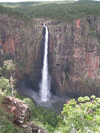
| photo_caption | Wallaman Falls in Girringun National Park |
| map | Queensland |
| relief | yes |
| map_width | 250px |
| coordinates | |
| coords_ref | |
| location | North Queensland, Australia |
| type | Cascade, horsetail |
| elevation | 533 - |
| height | 305 m |
| height_longest | 268 m |
| number_drops | 2 |
| width | 15 m |
| average_width | 15 m |
| watercourse | Stony Creek |
| average_flow | 3 m3/s |
| world_rank | 294 |
| :: |
| name = Wallaman Falls | photo = Wallaman Falls.jpg | photo_width = 250 | photo_caption = Wallaman Falls in Girringun National Park | map = Queensland | relief = yes | map_width = 250px | coordinates = | coords_ref = | location = North Queensland, Australia | type = Cascade, horsetail | elevation = 533 - | height = 305 m | height_longest = 268 m | number_drops = 2 | width = 15 m | average_width = 15 m | watercourse = Stony Creek | average_flow = 3 m3/s | world_rank = 294 The Wallaman Falls, a cascade and horsetail waterfall on the Stony Creek, is located in the UNESCO World Heritage-listed Wet Tropics in the locality of Wallaman, Shire of Hinchinbrook in the northern region of Queensland, Australia. The waterfall is notable for its main drop of 268 m, which makes it the country's tallest single-drop waterfall. The pool at the bottom of the waterfall is 20 m deep. An estimated people visit the waterfall annually.
Location and features
The waterfall is situated in the Girringun National Park as it descends from the Atherton Tableland, where the Stony Creek, a tributary of the Herbert River, flows over an escarpment in the Seaview Range. The falls initially descend over a small number of cascades before the 268 m horsetail drop. In total, the falls descend over 305 m. Based on the falls' single-drop descent, the World Waterfall Database places Wallaman Falls at 294 in its world rankings.
The geological history of the formation may be traced back some 50 million years, when the uplift of the continental margin in the region created modern landforms. The Herbert River, which previously flowed west, began to cut through the terrain en route to its outflow in the Coral Sea. The gorge produced by this erosive action gradually retreated inland along the Herbert River's course at a rate of 40 cm per hundred years. The river's tributaries were eventually left suspended by this action, forming their own gorges.
References
References
- {{Gazetteer of Australia
- {{cite QPN. 36308. Wallaman Falls
- "Map of Wallaman Falls, QLD". Bonzle Digital Atlas of Australia.
- (23 November 2010). "Significant Waterfalls". [[Australian Government]].
- (3 July 2002). "Tallest waterfalls in Australia". [[Australian Government]].
- (21 May 2011). "Wallaman Falls". World Waterfall Database.
- (2014-05-15). "Significant Waterfalls".
- "Around Townsville National Parks & Reserves". Foundation for National Parks and Wildlife.
- Lloyd, Graham. (6 April 2013). "Wild Australia: Legends of the Wallaman falls". [[The Australian]].
- "Wallaman Falls, Girringun National Park: Nature, culture and history". Queensland Government.
::callout[type=info title="Wikipedia Source"] This article was imported from Wikipedia and is available under the Creative Commons Attribution-ShareAlike 4.0 License. Content has been adapted to SurfDoc format. Original contributors can be found on the article history page. ::