Ust-Omchug
title: "Ust-Omchug" type: doc version: 1 created: 2026-02-28 author: "Wikipedia contributors" status: active scope: public tags: ["urban-type-settlements-in-magadan-oblast"] topic_path: "general/urban-type-settlements-in-magadan-oblast" source: "https://en.wikipedia.org/wiki/Ust-Omchug" license: "CC BY-SA 4.0" wikipedia_page_id: 0 wikipedia_revision_id: 0
::data[format=table title="Infobox Russian urban-type settlement"]
| Field | Value |
|---|---|
| en_name | Ust-Omchug |
| ru_name | Усть-Омчуг |
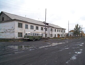
| image_skyline | Ust-Omchug-buildings.jpg |
| image_caption | Ust-Omchug, September 2004 |
| coordinates | |
| map_label_position | right |
| federal_subject | Magadan Oblast |
| adm_district_jur | Tenkinsky District |
| inhabloc_cat | Urban-type settlement |
| pop_2010census | 3,914 |
| pop_2010census_ref | |
| pop_latest | 3,273 |
| pop_latest_date | 1 January 2017 |
| pop_latest_ref | |
| mapframe | yes |
| mapframe-zoom | 12 |
| mapframe-wikidata | yes |
| mapframe-marker | village |
| :: |
|en_name=Ust-Omchug |ru_name=Усть-Омчуг |image_skyline=Ust-Omchug-buildings.jpg |image_caption=Ust-Omchug, September 2004 |coordinates = |map_label_position=right |image_coa= |coa_caption= |image_flag= |flag_caption= |anthem= |anthem_ref= |holiday= |holiday_ref= |federal_subject=Magadan Oblast |federal_subject_ref= |adm_data_as_of= |adm_district_jur=Tenkinsky District |adm_district_jur_ref= |adm_ctr_of= |adm_ctr_of_ref= |inhabloc_cat=Urban-type settlement |inhabloc_cat_ref= |inhabloc_type= |inhabloc_type_ref= |mun_data_as_of= |mun_district_jur= |mun_district_jur_ref= |urban_settlement_jur= |urban_settlement_jur_ref= |mun_admctr_of= |mun_admctr_of_ref= |leader_title= |leader_title_ref= |leader_name= |leader_name_ref= |representative_body= |representative_body_ref= |area_of_what= |area_as_of= |area_km2= |area_km2_ref= |pop_2010census=3,914 |pop_2010census_ref= |pop_density= |pop_density_as_of= |pop_density_ref= |pop_latest=3,273 |pop_latest_date=1 January 2017 |pop_latest_ref= |established_date= |established_title= |established_date_ref= |current_cat_date= |current_cat_date_ref= |prev_name1= |prev_name1_date= |prev_name1_ref= |postal_codes= |postal_codes_ref= |dialing_codes= |dialing_codes_ref= |website= |website_ref= | mapframe = yes | mapframe-zoom = 12 | mapframe-wikidata = yes | mapframe-marker = village
Ust-Omchug () is an urban locality (an urban-type settlement) and the administrative center of Tenkinsky District of Magadan Oblast, Russia, located at the 271 km mark of the highway to the northwest of Magadan. Population:
History
Urban-type settlement status was granted to Ust-Omchug in 1953.
Some 56 km north from the settlement there are couple of other abandoned settlements that once were part of the TenLag. They are Butugichag and Lower Butugichag. The settlements were part of the Soviet correctional system of GULAG.
Economy
There is an ore-mining and processing plant, a mining equipment repair shop, a timber industry company, and a poultry farming sovkhoz.
Climate
Ust-Omchug has a very cold subarctic climate (Köppen climate classification Dfc). Winters are prolonged and very cold, with up to eight months of sub-zero maximum daily temperatures, such that the soil remains permanently frozen. Permafrost and tundra cover most of the region. Average temperatures range from −32.6 C in January to +12.7 C in July.
|location=Ust-Omchug |metric first=yes |single line=yes |Jan mean C = -32.6 |Feb mean C = -31.2 |Mar mean C = -24.2 |Apr mean C = -13.4 |May mean C = -3.3 |Jun mean C = 8.4 |Jul mean C = 12.7 |Aug mean C = 9.1 |Sep mean C = 1.2 |Oct mean C = -12.5 |Nov mean C = -26.2 |Dec mean C = -32.4 |year mean C = -12.0 |Jan precipitation mm = 15 |Feb precipitation mm = 13 |Mar precipitation mm = 7 |Apr precipitation mm = 13 |May precipitation mm = 28 |Jun precipitation mm = 46 |Jul precipitation mm = 67 |Aug precipitation mm = 60 |Sep precipitation mm = 48 |Oct precipitation mm = 38 |Nov precipitation mm = 24 |Dec precipitation mm = 16 |Jan humidity = 69.4 |Feb humidity = 69.6 |Mar humidity = 74.5 |Apr humidity = 80.7 |May humidity = 82.4 |Jun humidity = 69.9 |Jul humidity = 68.0 |Aug humidity = 74.7 |Sep humidity = 80.8 |Oct humidity = 80.2 |Nov humidity = 74.4 |Dec humidity = 69.6 |year humidity= 74.5 |source 1 = NASA RETScreen Database |source 2 =Climate-data.org
Gallery
File:Arial view of Ust-Omchug 1958.png|Aerial view in 1958 File:Ust-Omchug-ruins.jpg|Ruined structures File:Ust-Omchug-power.jpg|Electricity substation File:Ust-Omchug petrol station, Magadan Oblast, Siberia.jpg|Gas station
References
References
- {{ru-pop-ref. 2010Census
- Office of the [[Russian Federal State Statistics Service. Federal State Statistics Service]] for Khabarovsk Krai, Magadan Oblast, Jewish Autonomous Oblast and Chukotka Autonomous Okrug. [http://habstat.gks.ru/wps/wcm/connect/rosstat_ts/habstat/resources/5cdceb0041e66a1d8bc1ff27f9898572/%D0%A7%D0%B8%D1%81%D0%BB%D0%B5%D0%BD%D0%BD%D0%BE%D1%81%D1%82%D1%8C+%D0%BD%D0%B0%D1%81%D0%B5%D0%BB%D0%B5%D0%BD%D0%B8%D1%8F++%D0%9C%D0%B0%D0%B3%D0%B0%D0%B4%D0%B0%D0%BD%D1%81%D0%BA%D0%BE%D0%B9+%D0%BE%D0%B1%D0%BB%D0%B0%D1%81%D1%82%D0%B8+%D0%BF%D0%BE+%D0%BC%D1%83%D0%BD%D0%B8%D1%86%D0%B8%D0%BF%D0%B0%D0%BB%D1%8C%D0%BD%D1%8B%D0%BC+%D0%BE%D0%B1%D1%80%D0%B0%D0%B7%D0%BE%D0%B2%D0%B0%D0%BD%D0%B8%D1%8F%D0%BC+%D0%BD%D0%B0+1+%D1%8F%D0%BD%D0%B2%D0%B0%D1%80%D1%8F+2017+%D0%B3%D0%BE%D0%B4%D0%B0.doc Численность населения Магаданская область по муниципальным образованиям на 1 января 2017 года] {{in lang. ru
::callout[type=info title="Wikipedia Source"] This article was imported from Wikipedia and is available under the Creative Commons Attribution-ShareAlike 4.0 License. Content has been adapted to SurfDoc format. Original contributors can be found on the article history page. ::