Surava
title: "Surava" type: doc version: 1 created: 2026-02-28 author: "Wikipedia contributors" status: active scope: public tags: ["albula/alvra", "former-municipalities-of-the-grisons"] topic_path: "general/albula-alvra" source: "https://en.wikipedia.org/wiki/Surava" license: "CC BY-SA 4.0" wikipedia_page_id: 0 wikipedia_revision_id: 0
::data[format=table title="Infobox Swiss town"]
| Field | Value |
|---|---|
| subject_name | Surava |
| image_photo | Surava Dorf.jpg |
| municipality_type | former |
| imagepath_coa | Surava wappen.svg |
| imagepath_flag | Flag of Surava.gif |
| canton | Graubünden |
| iso-code-region | CH-GR |
| district | Albula |
| coordinates | |
| postal_code | 7472 |
| municipality_code | 3515 |
| area | 7.0 |
| elevation | 904 |
| population | 196 |
| website | www.albula-alvra.ch |
| mayor | |
| mayor_title | |
| neighboring_municipalities | Alvaneu, Brienz/Brinzauls, Tiefencastel |
| :: |
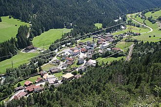
| subject_name = Surava | image_photo = Surava Dorf.jpg | municipality_type = former | imagepath_coa = Surava wappen.svg | imagepath_flag = Flag of Surava.gif | languages = | canton = Graubünden | iso-code-region = CH-GR | district = Albula |coordinates = | postal_code = 7472 | municipality_code = 3515 | area = 7.0 | elevation = 904|elevation_description= | population = 196 |populationof= Dec 2013 | website = www.albula-alvra.ch | mayor = |mayor_asof=|mayor_party= | mayor_title = |list_of_mayors = | places = | demonym = | neighboring_municipalities= Alvaneu, Brienz/Brinzauls, Tiefencastel | twintowns = |}} Surava is a village and former municipality in the district of Albula in the canton of Graubünden in Switzerland. On 1 January 2015 the former municipalities of Alvaschein, Mon, Stierva, Tiefencastel, Alvaneu, Brienz/Brinzauls and Surava merged to form the new municipality of Albula/Alvra.
History
Surava is first mentioned about 1580 as Surraguas.
Geography
::figure[src="https://upload.wikimedia.org/wikipedia/commons/6/65/Belfort_Vorburg_Surava.jpg" caption="Ruins of Belfort Castle, above Surava"] ::
::figure[src="https://upload.wikimedia.org/wikipedia/commons/6/6f/ETH-BIB-Surava,_Blick_nach_Westen,_Muttnerhorn-LBS_H1-018126.tif" caption="Aerial view (1954)"] ::
Before the merger, Surava had a total area of 7.0 km2. Of this area, 10.6% is used for agricultural purposes, while 78.3% is forested. Of the rest of the land, 4.3% is settled (buildings or roads) and the remainder (6.8%) is non-productive (rivers, glaciers or mountains).
The former municipality is located in the Belfort sub-district of the Albula District. It consists of the linear village of Surava on the right bank of the Albula river. In 1883 the municipality of Brienz-Surava split into Brienz/Brinzauls and Surava.
Demographics
Surava had a population (as of 2013) of 196. , 7.0% of the population was made up of foreign nationals. Over the last 10 years the population has decreased at a rate of -22%.
, the gender distribution of the population was 52.8% male and 47.2% female. The age distribution, , in Surava is; 9 people or 12.0% of the population are between 0 and 9 years old. 6 people or 8.0% are 10 to 14, and 7 people or 9.3% are 15 to 19. Of the adult population, 4 people or 5.3% of the population are between 20 and 29 years old. 10 people or 13.3% are 30 to 39, 14 people or 18.7% are 40 to 49, and 10 people or 13.3% are 50 to 59. The senior population distribution is 4 people or 5.3% of the population are between 60 and 69 years old, 3 people or 4.0% are 70 to 79, there are 7 people or 9.3% who are 80 to 89, and there are 1 people or 1.3% who are 90 to 99.
In the 2007 federal election the most popular party was the CVP which received 43.7% of the vote. The next three most popular parties were the SVP (32.6%), the FDP (18.6%) and the SPS (5.1%).
In Surava about 66.2% of the population (between age 25-64) have completed either non-mandatory upper secondary education or additional higher education (either university or a Fachhochschule).
Surava has an unemployment rate of 0.67%. , there were 8 people employed in the primary economic sector and about 3 businesses involved in this sector. 22 people are employed in the secondary sector and there are 7 businesses in this sector. 35 people are employed in the tertiary sector, with 8 businesses in this sector.
The historical population is given in the following table: ::data[format=table]
| year | population |
|---|---|
| 1725 | 89 |
| 1850 | 159 |
| 1900 | 148 |
| 1950 | 203 |
| 1960 | 136 |
| 1970 | 93 |
| 1980 | 62 |
| 1990 | 73 |
| 2000 | 150 |
| :: |
Language
Most of the population () speaks German (78.4%), with Romansh being second most common (10.8%) and Albanian being third ( 2.8%).
::data[format=table title="Languages in Surava"]
| Languages | Census 1980 | Census 1990 | Census 2000 | Number | Percent | Number | Percent | Number | Percent |
|---|---|---|---|---|---|---|---|---|---|
| German | 116 | 60.42% | 161 | 76.67% | 196 | 78.40% | |||
| Romanish | 66 | 34.38% | 45 | 21.43% | 27 | 10.80% | |||
| Italian | 10 | 5.21% | 2 | 0.95% | 4 | 1.60% | |||
| Population | 192 | 100% | 210 | 100% | 250 | 100% | |||
| :: |
References
References
- [http://www.bfs.admin.ch/bfs/portal/de/index/infothek/nomenklaturen/blank/blank/gem_liste/03.html Amtliches Gemeindeverzeichnis der Schweiz] published by the Swiss Federal Statistical Office {{in lang. de accessed 23 September 2009
- [http://www.bfs.admin.ch/bfs/portal/en/index/regionen/02/key.html Swiss Federal Statistical Office] accessed 15 January 2015
- [http://www.gr.ch/DE/institutionen/verwaltung/dvs/awt/dienstleistungen/volkswirtschaftlichegrundlagen/Seiten/default.aspx Graubunden in Numbers] {{Webarchive. link. (2009-09-24 {{in lang). de accessed 21 September 2009
- [http://www.gr.ch/DE/institutionen/verwaltung/dvs/awt/dienstleistungen/volkswirtschaftlichegrundlagen/Seiten/Bevoelkerung.aspx Graubunden Population Statistics] {{Webarchive. link. (2009-08-27 {{in lang). de accessed 21 September 2009
- {{HDS. 1418. Surava
::callout[type=info title="Wikipedia Source"] This article was imported from Wikipedia and is available under the Creative Commons Attribution-ShareAlike 4.0 License. Content has been adapted to SurfDoc format. Original contributors can be found on the article history page. ::