Slidre
Village in Vestre Slidre, Norway
title: "Slidre" type: doc version: 1 created: 2026-02-28 author: "Wikipedia contributors" status: active scope: public tags: ["vestre-slidre-municipality", "villages-in-innlandet"] description: "Village in Vestre Slidre, Norway" topic_path: "general/vestre-slidre-municipality" source: "https://en.wikipedia.org/wiki/Slidre" license: "CC BY-SA 4.0" wikipedia_page_id: 0 wikipedia_revision_id: 0
::summary Village in Vestre Slidre, Norway ::
::data[format=table title="Infobox settlement"]
| Field | Value |
|---|---|
| official_name | Slidre |
| settlement_type | Village |
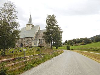
| image_skyline | Vøllavegen forbi Slidredomen.jpg |
| image_caption | View of the road past Slidredomen |
| mapframe | yes |
| mapframe-zoom | 11 |
| mapframe-marker | village |
| pushpin_map | Innlandet#Norway |
| pushpin_label_position | top |
| subdivision_type | Country |
| subdivision_name | Norway |
| subdivision_type1 | Region |
| subdivision_name1 | Eastern Norway |
| subdivision_type2 | County |
| subdivision_name2 | Innlandet |
| subdivision_type3 | District |
| subdivision_name3 | Valdres |
| subdivision_type4 | Municipality |
| subdivision_name4 | Vestre Slidre Municipality |
| timezone1 | CET |
| utc_offset1 | +01:00 |
| timezone1_DST | CEST |
| utc_offset1_DST | +02:00 |
| area_footnotes | |
| area_total_km2 | 0.47 |
| population_as_of | 2024 |
| population_footnotes | |
| population_total | 310 |
| population_density_km2 | 660 |
| postal_code_type | Post Code |
| postal_code | 2966 Slidre |
| coordinates | |
| elevation_m | 397 |
| elevation_footnotes | |
| :: |
|official_name = Slidre |other_name = |native_name = |native_name_lang = |nickname = |settlement_type = Village |image_skyline = Vøllavegen forbi Slidredomen.jpg |image_caption = View of the road past Slidredomen |mapframe = yes |mapframe-zoom = 11 |mapframe-marker = village |pushpin_map = Innlandet#Norway |pushpin_label = |pushpin_label_position = top |subdivision_type = Country |subdivision_name = Norway |subdivision_type1 = Region |subdivision_name1 = Eastern Norway |subdivision_type2 = County |subdivision_name2 = Innlandet |subdivision_type3 = District |subdivision_name3 = Valdres |subdivision_type4 = Municipality |subdivision_name4 = Vestre Slidre Municipality |timezone1 = CET |utc_offset1 = +01:00 |timezone1_DST = CEST |utc_offset1_DST = +02:00 |area_footnotes = |area_total_km2 = 0.47 |population_as_of = 2024 |population_footnotes = |population_total = 310 |population_density_km2 = 660 |postal_code_type = Post Code |postal_code = 2966 Slidre |coordinates = |elevation_m = 397 |elevation_footnotes = }}
Slidre is the administrative centre of Vestre Slidre Municipality in Innlandet county, Norway. The village is located along the Slidrefjorden in the Valdres district. The village is located along the European route E16 highway, about 25 km northwest of Fagernes.
The 0.47 km2 village has a population (2024) of 310 and a population density of 660 PD/km2.
History
Slidre is the site of the Slidredomen, a medieval era stone church. The village was the administrative centre of the old Slidre Municipality which existed from 1838 until 1849 when the municipality was divided.
Name
The municipality (and the parish) were named after the old Slidre farm ( or Slíðrir) since this was the location of the first Slidre Church that was built during the 12th century. The meaning of the name is not definitively known. It could be derived from the word slir which means the narrow depression through which a river runs.
References
References
- "Slidre, Vestre Slidre". [[yr.no]].
- "Informasjon om stadnamn". [[Norwegian Mapping Authority.
- {{Cite SNL. Slidre. Slidre. 2025-08-30. Mæhlum. Lars. 2025-08-18
- {{Cite SNL. Slidre_-_tettsted. Slidre (tettsted). 2025-08-30. Mæhlum. Lars. 2025-08-01
- Statistisk sentralbyrå. (2024-10-01). "Urban settlements. Population and area, by municipality".
- Rygh, Oluf. (1900). "Norske gaardnavne: Kristians amt". W. C. Fabritius & sønners bogtrikkeri.
::callout[type=info title="Wikipedia Source"] This article was imported from Wikipedia and is available under the Creative Commons Attribution-ShareAlike 4.0 License. Content has been adapted to SurfDoc format. Original contributors can be found on the article history page. ::