Scharans
title: "Scharans" type: doc version: 1 created: 2026-02-28 author: "Wikipedia contributors" status: active scope: public tags: ["scharans", "municipalities-of-the-grisons", "cultural-property-of-national-significance-in-the-grisons"] topic_path: "general/scharans" source: "https://en.wikipedia.org/wiki/Scharans" license: "CC BY-SA 4.0" wikipedia_page_id: 0 wikipedia_revision_id: 0
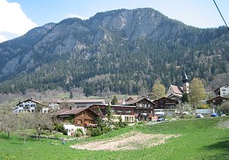
::data[format=table title="Infobox Swiss town"]
| Field | Value |
|---|---|
| subject_name | Scharans |
| image_photo | Scharans.jpg |
| municipality_type | municipality |
| imagepath_coa | CHE Scharans COA.svg |
| imagepath_flag | CHE Scharans Flag.svg |
| canton | Grisons |
| iso-code-region | CH-GR |
| district | Viamala |
| coordinates | |
| postal_code | 7412 |
| municipality_code | 3638 |
| area | 14.29 |
| elevation | 760 |
| population | |
| website | www.scharans.ch |
| mayor | |
| mayor_title | |
| neighboring_municipalities | Almens, Fürstenau, Sils im Domleschg, Vaz/Obervaz |
| :: |
| subject_name = Scharans | image_photo = Scharans.jpg | municipality_type = municipality | imagepath_coa = CHE Scharans COA.svg | imagepath_flag = CHE Scharans Flag.svg | languages = | canton = Grisons | iso-code-region = CH-GR | district = Viamala |coordinates = | postal_code = 7412 | municipality_code = 3638 | area = 14.29 | elevation = 760|elevation_description= | population = | populationof = | popofyear = | website = www.scharans.ch | mayor = |mayor_asof=|mayor_party= | mayor_title = |list_of_mayors = | places = | demonym = | neighboring_municipalities= Almens, Fürstenau, Sils im Domleschg, Vaz/Obervaz | twintowns = |}} Scharans (Romansh: Scharons) is a municipality in the Viamala Region in the Swiss canton of the Grisons.
History
Scharans is first mentioned in 1200 as agrum Schraunis.
Geography
::figure[src="https://upload.wikimedia.org/wikipedia/commons/b/be/ETH-BIB-Viamala,_Scharans,_Surettahorn,_Piz_Tambo_v._O._aus_2000_m-Inlandflüge-LBS_MH01-004439.tif" caption="Aerial view from 2000 m by [[Walter Mittelholzer]] (1925)"] ::
Scharans has an area, , of 14.3 km2. Of this area, 26.1% is used for agricultural purposes, while 62% is forested. Of the rest of the land, 2.9% is settled (buildings or roads) and the remainder (9%) is non-productive (rivers, glaciers or mountains).
Before 2017, the municipality was located in the Domleschg sub-district, of the Hinterrhein district, after 2017 it was part of the Viamala Region. It consists of the haufendorf (an irregular, unplanned and quite closely packed village, built around a central square) of Scharans and the hamlets of St. Agata, Stufels, Parnegl and Prin. It is located on a low terrace on the right hand side of the Albula and Hinterrhein rivers.
Demographics
Scharans has a population (as of ) of . , 5.1% of the population was made up of foreign nationals. Over the last 10 years the population has grown at a rate of 14.9%.
, the gender distribution of the population was 49.1% male and 50.9% female. The age distribution, , in Scharans is; 267 people or 8.7% of the population are between 0 and 9 years old. 155 people or 5.1% are 10 to 14, and 281 people or 9.2% are 15 to 19. Of the adult population, 460 people or 15.0% of the population are between 20 and 29 years old. 541 people or 17.6% are 30 to 39, 462 people or 15.1% are 40 to 49, and 385 people or 12.5% are 50 to 59. The senior population distribution is 209 people or 6.8% of the population are between 60 and 69 years old, 189 people or 6.2% are 70 to 79, there are 103 people or 3.4% who are 80 to 89, and there are 17 people or 0.6% who are 90 to 99.
In the 2007 federal election the most popular party was the SVP which received 37.6% of the vote. The next three most popular parties were the SPS (34.4%), the FDP (15.8%) and the CVP (6.6%).
In Scharans about 74.9% of the population (between age 25-64) have completed either non-mandatory upper secondary education or additional higher education (either university or a Fachhochschule).
Scharans has an unemployment rate of 1.08%. , there were 32 people employed in the primary economic sector and about 15 businesses involved in this sector. 21 people are employed in the secondary sector and there are 6 businesses in this sector. 236 people are employed in the tertiary sector, with 23 businesses in this sector.
From the , 1,180 or 38.4% are Roman Catholic, while 1,510 or 49.2% belonged to the Swiss Reformed Church. Of the rest of the population, there are less than 5 individuals who belong to the Christian Catholic faith, there are 76 individuals (or about 2.48% of the population) who belong to the Orthodox Church, and there are 60 individuals (or about 1.96% of the population) who belong to another Christian church. There are 19 (or about 0.62% of the population) who are Islamic. There are 11 individuals (or about 0.36% of the population) who belong to another church (not listed on the census), 135 (or about 4.40% of the population) belong to no church, are agnostic or atheist, and 78 individuals (or about 2.54% of the population) did not answer the question.
The historical population is given in the following table: ::data[format=table]
| year | population |
|---|---|
| 1803 | 336 |
| 1850 | 416 |
| 1900 | 439 |
| 1950 | 480 |
| 1960 | 473 |
| 2000 | 817 |
| :: |
Languages
Most of the population () speaks German (95.7%), with Romansh being second most common ( 2.1%) and Italian being third ( 0.9%).
::data[format=table title="Languages in Scharans"]
| Languages | Census 1980 | Census 1990 | Census 2000 | Number | Percent | Number | Percent | Number | Percent |
|---|---|---|---|---|---|---|---|---|---|
| German | 484 | 82.59% | 628 | 89.46% | 782 | 95.72% | |||
| Romanish | 69 | 11.77% | 22 | 3.13% | 17 | 2.08% | |||
| Italian | 14 | 2.39% | 18 | 2.56% | 7 | 0.86% | |||
| Population | 586 | 100% | 702 | 100% | 817 | 100% | |||
| :: |
Heritage sites of national significance
The Haus Bardill (formerly known as Haus Gees) is listed as a Swiss heritage sites of national significance.
References
References
- [https://www.bfs.admin.ch/bfs/de/home/grundlagen/agvch.assetdetail.1666963.html Swiss Federal Statistical Office - Amtliches Gemeindeverzeichnis der Schweiz - Mutationsmeldungen 2016] accessed 16 February 2017
- [http://www.bfs.admin.ch/bfs/portal/en/index/regionen/02/key.html Swiss Federal Statistical Office] accessed 05-Oct-2009
- [http://www.gr.ch/DE/institutionen/verwaltung/dvs/awt/dienstleistungen/volkswirtschaftlichegrundlagen/Seiten/default.aspx Graubunden in Numbers] {{webarchive. link. (2009-09-24 {{in lang). de accessed 21 September 2009
- [http://www.gr.ch/DE/institutionen/verwaltung/dvs/awt/dienstleistungen/volkswirtschaftlichegrundlagen/Seiten/Bevoelkerung.aspx Graubunden Population Statistics] {{webarchive. link. (2009-08-27 {{in lang). de accessed 21 September 2009
- {{HDS. 1478. Scharans
- [http://www.bevoelkerungsschutz.admin.ch/internet/bs/de/home/themen/kgs/kgs_inventar.html Swiss inventory of cultural property of national and regional significance] {{webarchive. link. (2009-05-01 21.11.2008 version, {{in lang). de accessed 05-Oct-2009
::callout[type=info title="Wikipedia Source"] This article was imported from Wikipedia and is available under the Creative Commons Attribution-ShareAlike 4.0 License. Content has been adapted to SurfDoc format. Original contributors can be found on the article history page. ::