Sajur River
Tributary of the Euphrates
title: "Sajur River" type: doc version: 1 created: 2026-02-28 author: "Wikipedia contributors" status: active scope: public tags: ["rivers-of-syria", "rivers-of-turkey", "geography-of-aleppo-governorate", "international-rivers-of-asia", "landforms-of-gaziantep-province", "tributaries-of-the-euphrates-river"] description: "Tributary of the Euphrates" topic_path: "geography" source: "https://en.wikipedia.org/wiki/Sajur_River" license: "CC BY-SA 4.0" wikipedia_page_id: 0 wikipedia_revision_id: 0
::summary Tributary of the Euphrates ::
::data[format=table title="Infobox river"]
| Field | Value |
|---|---|
| name | Sajur River |
| native_name | ar |
| name_other | Sacır Suyu Turkish |
| map | Bassin Tigre Euphrate.jpg |
| map_size | 300 |
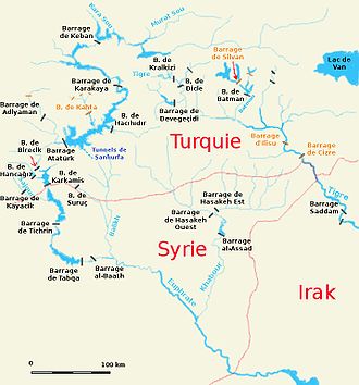
| map_caption | Map (in French) of the Syro–Turkish part of the Euphrates basin with the Sajur (Sajour) in the left |
| pushpin_map_size | 300 |
| subdivision_type1 | Country |
| subdivision_name1 | Turkey, Syria |
| subdivision_type3 | Region |
| subdivision_name3 | Middle East |
| subdivision_type5 | City |
| subdivision_name5 | Gaziantep |
| length | 108 km |
| discharge1_min | 1.4 m3/s |
| discharge1_avg | 4.1 m3/s |
| discharge1_max | 7 m3/s |
| mouth | Euphrates |
| mouth_location | Syria |
| mouth_coordinates | |
| basin_size | 2042 km2 |
| :: |
| name = Sajur River | native_name =ar | name_other = Sacır Suyu Turkish | name_etymology = | image = | image_size = | image_caption = | map = Bassin Tigre Euphrate.jpg | map_size = 300 | map_caption = Map (in French) of the Syro–Turkish part of the Euphrates basin with the Sajur (Sajour) in the left | pushpin_map = | pushpin_map_size = 300 | pushpin_map_caption= | subdivision_type1 = Country | subdivision_name1 = Turkey, Syria | subdivision_type2 = | subdivision_name2 = | subdivision_type3 = Region | subdivision_name3 = Middle East | subdivision_type4 = | subdivision_name4 = | subdivision_type5 = City | subdivision_name5 = Gaziantep | length = 108 km | width_min = | width_avg = | width_max = | depth_min = | depth_avg = | depth_max = | discharge1_location= | discharge1_min = 1.4 m3/s | discharge1_avg = 4.1 m3/s | discharge1_max = 7 m3/s | source1 = | source1_location = | source1_coordinates= | source1_elevation = | mouth = Euphrates | mouth_location = Syria | mouth_coordinates = | mouth_elevation = | progression = | river_system = | basin_size = 2042 km2 | tributaries_left = | tributaries_right = | custom_label = | custom_data = | extra =
The Sajur ( ; ) is a 108 km long river originating in Turkey and flowing into the Euphrates in Syria. It is the smallest of the three rivers joining the Euphrates in Syria, and the only one that joins the Euphrates on its western bank. Occupation in the Sajur basin started in the Lower Palaeolithic period and continues until today.
Course
The Sajur River is 108 km long, of which 60 km are in Turkey and 48 km in Syria. It is thought to originate in a place to the west of Gaziantep, called Sacır Başı in Turkish. Its name changes to Kavaklık deresi in the historic outskirts of Gaziantep, then to Alleben deresi in the old town, and later to Tabakhane deresi ( tannery stream). As it leaves the old town dirty, it becomes Kara Akar ( black-flowing), regaining its original name Sajur shortly after. From there, the Sajur flows southeast until it crosses the Syria–Turkey border. The river then continues in a roughly easterly direction until it joins the Euphrates on its right bank in the area that is flooded by the Tishrin Dam reservoir. In Syria, the river cuts a valley into the Manbij Plain that is between 20 and below the level of the plain, and up to 500 m wide. Average discharge is 4.1 m3 per second. Maximum discharge, occurring in the months February and March, is 7 m3 per second, while minimum discharge, recorded for June–October, is 1.4 m3 per second. Average annual discharge is 0.14 km3. Both in terms of length, as well as discharge, the Sajur is the smallest of the three rivers that join the Euphrates on Syrian soil – the other two being the Balikh and the Khabur. The Sajur is also the only river in Syria that enters the Euphrates on its right bank; both the Balikh and the Khabur flow into the Euphrates on the left bank.
Drainage basin
The Sajur drains a total area of 2042 km2. The Manbij Plain experiences a continental climate. Average temperatures range from 5 °C in January to 30 °C in July. Annual average precipitation is 300 mm, but ranges from a minimum of 141 mm per year in dry years to 424 mm per year in exceptionally wet years. Although much of the area is cultivated today, combined palaeobotanical, climate and vegetation research suggest that the basin would support a xeric woodland vegetation with open oak forest and Rosaceae (rose/plum family) in the absence of human activity.
History
Occupation of the Sajur river basin started as early as the Lower Palaeolithic period, as evidenced by Acheulean stone artefacts. Middle Palaeolithic artefacts have been found as well.
Economy
Both Turkey and Syria use water from the Sajur for irrigation purposes. Since the 19th century, occupation in and cultivation of the Sajur basin have steadily increased, especially in the western, more fertile part of the area. The introduction of motorized pumps has led to a considerable decrease of the groundwater table, with the effect that many wells have dried up. Turkey has built the Kayacık Dam on the Ayfinar Deresi, one of the two streams that join to form the Sajur. This 45 m high dam creates a reservoir with a surface area of 11 km2. From this reservoir, an area of 200 km2 is irrigated. A dam with a planned reservoir capacity of 0.0098 km3 is under construction on the Syrian part of the Sajour. The city of Aleppo disposes part of its wastewater into the Sajur drainage system.
Notes
References
References
- "Geçmişten Bugüne Oğuzeli Tarihi".
- {{harvnb. Kolars. Mitchell. 1991
- "Kâmil Ocak Stadyum Meydanı'nın Veya Çıksorut'un Eski Adı Neydi?".
- {{harvnb. Rawlinson. 1880
- {{harvnb. Besançon. Sanlaville. 1985
- Besançon. Sanlaville. 1985
- Kolars. Mitchell. 1991
- {{harvnb. Besançon. Sanlaville. 1981
- {{harvnb. Besançon. Sanlaville. 1985
- {{harvnb. Moore. Hillman. Legge. 2000
- {{harvnb. Besançon. Sanlaville. 1981
- {{harvnb. Muhesen. 2002
- {{harvnb. Besançon. Sanlaville. 1985
- "Kayacik Dam". www.dsi.gov.tr.
- {{harvnb. Daoudy. 2005
- {{harvnb. Kaisi. Yasser. Mahrouseh. n.d.
::callout[type=info title="Wikipedia Source"] This article was imported from Wikipedia and is available under the Creative Commons Attribution-ShareAlike 4.0 License. Content has been adapted to SurfDoc format. Original contributors can be found on the article history page. ::