Rhinow
title: "Rhinow" type: doc version: 1 created: 2026-02-28 author: "Wikipedia contributors" status: active scope: public tags: ["localities-in-havelland-(district)"] topic_path: "general/localities-in-havelland-district" source: "https://en.wikipedia.org/wiki/Rhinow" license: "CC BY-SA 4.0" wikipedia_page_id: 0 wikipedia_revision_id: 0
::data[format=table title="Infobox German location"]
| Field | Value |
|---|---|
| type | Stadt |
| image_coa | Wappen_Rhinow.PNG |
| coordinates | |
| image_plan | Rhinow in HVL.png |
| state | Brandenburg |
| district | Havelland |
| Amt | Rhinow |
| elevation | 30 |
| area | 31.66 |
| postal_code | 14728 |
| area_code | 033875 |
| licence | HVL |
| Gemeindeschlüssel | 12063260 |
| website | www.rhinow.de |
| mayor | Stefan Schneider |
| leader_term | 2024–29 |
| party | SPD |
| :: |
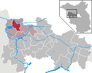
|type = Stadt |image_coa = Wappen_Rhinow.PNG |coordinates = |image_plan = Rhinow in HVL.png |state = Brandenburg |district = Havelland |Amt = Rhinow |elevation = 30 |area = 31.66 |postal_code = 14728 |area_code = 033875 |licence = HVL |Gemeindeschlüssel = 12063260 |website = www.rhinow.de |mayor = Stefan Schneider |leader_term = 2024–29 |party = SPD Rhinow () is a town in the Havelland district (Landkreis), in Brandenburg, Germany. It is situated 16 km north of Rathenow, and 22 km south of Kyritz. Rhinow is the administrative seat (Verwaltungssitz) of the Rhinow district (Amt).
Geography
The region lies on the southern edge of the Rhinluch (Rhin moor) and at the feet of the up to 110 Meter high Rhinower Mountains. The Rhin river flows west through the district into the Gülper See at the southwestern border. Federal highway (Bundesstraße) 102 cuts through the area. Since 2003, the stretch between Rathenow and Neustadt (Dosse) is no longer served by public rail transit (Öffentlichen Personennahverkehr).
Administrative division
Greater Rhinow includes the village of Kietz.
History
During the Third Reich, a famous sail plane school was founded in memory of Otto Lilienthal.
Demography
::figure[src="https://upload.wikimedia.org/wikipedia/commons/e/ec/Bevölkerungsentwicklung_Rhinow.pdf" caption="Development of population since 1875 within the current boundaries (Blue line: Population; Dotted line: Comparison to population development of Brandenburg state; Grey background: Time of Nazi rule; Red background: Time of communist rule)"] ::
|align=none | cols=2 | percentages=pagr |title = Rhinow: Population development within the current boundaries (2013) | 1875 | 1397 | 1890 | 1512 | 1910 | 1540 | 1925 | 1533 | 1933 | 1551 | 1939 | 1713 | 1946 | 2728 | 1950 | 2553 | 1964 | 2051 | 1971 | 2052 | 1981 | 2198 | 1985 | 2213 | 1989 | 2222 | 1990 | 2146 | 1991 | 2090 | 1992 | 2065 | 1993 | 2086 | 1994 | 2070 | 1995 | 2103 | 1996 | 2111 | 1997 | 2154 | 1998 | 2165 | 1999 | 2146 | 2000 | 2101 | 2001 | 2021 | 2002 | 2012 | 2003 | 1967 | 2004 | 1959 | 2005 | 1933 | 2006 | 1874 | 2007 | 1821 | 2008 | 1758 | 2009 | 1714 | 2010 | 1716 | 2011 | 1695 | 2012 | 1667 | 2013 | 1640 | 2014 | 1649 | 2015 | 1625 | 2016 | 1614
Politics
City Council
The council of the city of Rhinow has 12 members with the following distribution by political party:
(As of elections held on September 28, 2008)
Elections in 2014:
- SPD: 4
- FDP: 2
- The Left: 2
- CDU: 1
- Single candidates: 3
Architecture
- 101 Meter high radio tower belonging to Deutsche Telekom AG constructed from reinforced concrete with uncustomary asymmetry at 52° 44′ 45″ N, 12° 21′ 7″ E, was built during the Soviet era.
Personalities
- Otto Lilienthal (1848-1896), settled in Rhinow in 1893, building his workshop for his glider. In the beginning, he flew also in the Rhinow Mountains, later switching to flying at Gollenberg.
References
References
- [https://wahlen.brandenburg.de/wahlen/de/kommunalwahlen/ergebnisse/buergermeisterwahlen/ergebnisse/~12063000 Landkreis Havelland Wahl der Bürgermeisterin / des Bürgermeisters]. Retrieved 3 July 2024.
- Detailed data sources are to be found in the Wikimedia Commons.[http://commons.wikimedia.org/wiki/Category:Population_projection_Brandenburg Population Projection Brandenburg at Wikimedia Commons]
- [https://www.wahlergebnisse.brandenburg.de/wahlen/KO2014/gemver/ergebgemver.asp?sel1=4350&sel2=2075&gebiet=63809260 Ergebnis der Kommunalwahl am 25. Mai 2014]
::callout[type=info title="Wikipedia Source"] This article was imported from Wikipedia and is available under the Creative Commons Attribution-ShareAlike 4.0 License. Content has been adapted to SurfDoc format. Original contributors can be found on the article history page. ::