Renfrew County
County in Ontario, Canada
title: "Renfrew County" type: doc version: 1 created: 2026-02-28 author: "Wikipedia contributors" status: active scope: public tags: ["renfrew-county", "counties-in-ontario"] description: "County in Ontario, Canada" topic_path: "general/renfrew-county" source: "https://en.wikipedia.org/wiki/Renfrew_County" license: "CC BY-SA 4.0" wikipedia_page_id: 0 wikipedia_revision_id: 0
::summary County in Ontario, Canada ::
::data[format=table title="Infobox settlement"]
| Field | Value |
|---|---|
| name | Renfrew County |
| official_name | County of Renfrew |
| native_name | |
| settlement_type | County (upper-tier) |
| image_skyline | RenfrewCounty-Office.JPG |
| image_caption | The administration building of the county government |
| seal_size | 130px |
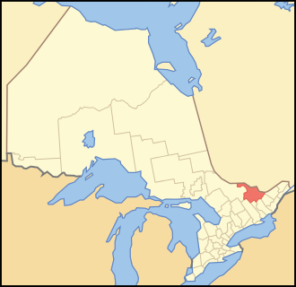
| image_map | Map of Ontario RENFREW.svg |
| map_caption | Location of Renfrew County |
| coordinates | |
| subdivision_type | Country |
| subdivision_name | Canada |
| subdivision_type1 | Province |
| subdivision_name1 | |
| subdivision_name2 | |
| established_title | Established |
| established_date | 1861 |
| seat_type | County seat |
| seat | Pembroke (independent) |
| parts_type | Municipalities |
| parts_style | |
| parts | |
| p1 | City of Arnprior |
| p2 | Town of Deep River |
| p3 | Town of Laurentian Hills |
| p4 | Town of Petawawa |
| p5 | Town of Renfrew |
| p6 | Township of Admaston/Bromley |
| p7 | Municipality of Bonnechere Valley |
| p8 | Township of Brudenell, Lyndoch and Raglan |
| p9 | Township of Greater Madawaska |
| p10 | Township of Head, Clara and Maria |
| p11 | Township of Horton |
| p12 | Township of Killaloe, Hagarty and Richards |
| p13 | Township of Laurentian Valley |
| p14 | Township of Madawaska Valley |
| p15 | Township of McNab/Braeside |
| p16 | Township of North Algona Wilberforce |
| p17 | Township of Whitewater Region |
| leader_title1 | |
| total_type | |
| area_footnotes | |
| area_total_km2 | |
| area_land_km2 | |
| area_blank1_title | Census div. |
| area_blank1_km2 | 7357.94 |
| area_note | Land area excludes Pembroke |
| elevation_footnotes | |
| population_total | |
| population_as_of | 2021 |
| population_footnotes | |
| population_density_km2 | |
| population_blank1_title | Census div. |
| population_blank1 | 106365 |
| population_density_blank1_km2 | 14.5 |
| population_note | Total excludes Pembroke |
| timezone | EST |
| utc_offset | -5 |
| timezone_DST | EDT |
| utc_offset_DST | -4 |
| postal_code_type | |
| area_codes | 613 and 343 |
| website | |
| :: |
::callout[type=note] the county in Ontario, Canada ::
| name = Renfrew County | official_name = County of Renfrew | native_name = | other_name = | settlement_type = County (upper-tier) | image_skyline = RenfrewCounty-Office.JPG | image_caption = The administration building of the county government | image_flag = | flag_size = | image_seal = | seal_size = 130px | image_shield = | shield_size = | image_blank_emblem = | blank_emblem_type = | blank_emblem_size = | nickname = | motto = | image_map = Map of Ontario RENFREW.svg | map_caption = Location of Renfrew County | coordinates = | subdivision_type = Country | subdivision_name = Canada | subdivision_type1 = Province | subdivision_type2 = | subdivision_name1 = | subdivision_name2 = | established_title = Established | established_date = 1861 | seat_type = County seat | seat = Pembroke (independent) | parts_type = Municipalities | parts_style = Default is list if up to 5 items, coll if more than 5-- | parts = | p1 = City of Arnprior | p2 = Town of Deep River | p3 = Town of Laurentian Hills | p4 = Town of Petawawa | p5 = Town of Renfrew | p6 = Township of Admaston/Bromley | p7 = Municipality of Bonnechere Valley | p8 = Township of Brudenell, Lyndoch and Raglan | p9 = Township of Greater Madawaska | p10 = Township of Head, Clara and Maria | p11 = Township of Horton | p12 = Township of Killaloe, Hagarty and Richards | p13 = Township of Laurentian Valley | p14 = Township of Madawaska Valley | p15 = Township of McNab/Braeside | p16 = Township of North Algona Wilberforce | p17 = Township of Whitewater Region | government_footnotes = | government_type = | leader_title = | leader_name = | leader_title1 = | leader_name1 = | total_type = | area_footnotes = | area_magnitude = | area_total_km2 = | area_land_km2 = | area_water_km2 = | area_water_percent = | area_blank1_title = Census div. | area_blank1_km2 = 7357.94 | area_note = Land area excludes Pembroke | elevation_footnotes = | elevation_m = | elevation_min_m = | elevation_max_m = | population_total = | population_as_of = 2021 | population_footnotes = | population_density_km2 = | population_blank1_title = Census div. | population_blank1 = 106365 | population_density_blank1_km2 = 14.5 | population_note = Total excludes Pembroke | timezone = EST | utc_offset = -5 | timezone_DST = EDT | utc_offset_DST = -4 | postal_code_type = | postal_code = | area_codes = 613 and 343 | website = | footnotes = Renfrew County is a county and census division in the Canadian province of Ontario. It is located on the west bank of the Ottawa River. There are 17 municipalities in the county. Its county seat is Pembroke, which is geographically within the county but administered independently.
History
Bathurst District
When Carleton County was withdrawn from Bathurst District in 1838, Renfrew County was severed from part of the remaining Lanark County, but the two remained united for electoral purposes. By 1845, all lands in the District had been surveyed into the following townships:
::data[format=table title="Counties comprising Bathurst District (1845)"]
| Lanark | Renfrew |
|---|---|
| :: |
United Counties of Lanark and Renfrew
Effective January 1, 1850, Bathurst District was abolished, and the "United Counties of Lanark and Renfrew" replaced it for municipal and judicial purposes. The counties remained united for electoral purposes in the Parliament of the Province of Canada, referred to as the County of Lanark, until Renfrew gained its own seat in 1853.
The separation of Renfrew from Lanark began in 1861, with the creation of a Provisional Municipal Council that held its first meeting in June 1861. The United Counties were dissolved in August 1866.
Geographical evolution
The territory was originally described in 1838 as consisting of:
...the Townships of Packenham, McNab, Horton, Ross, Westmeath and Pembroke, together with the unsurveyed lands within the District of Bathurst, and all the islands in the Ottawa River, wholly or in greater part opposite to the said Townships and unsurveyed lands...
In 1851, Pakenham was transferred to Lanark, while Renfrew was expanded through the addition of:
...all that tract of land lying between the Western Boundaries of the Townships of Lavant, Blithfield, Admaston, Bromley, Stafford and Pembroke and the Ottawa River, and a line drawn parallel to the general course of the said Boundaries of the said Townships from the western corner of the Township of Clarendon to the Ottawa River.
In 1860, the newly surveyed townships of Miller and Canonto were transferred to Frontenac County, while the townships of Raglan, Lyndoch, Radcliffe and Brudenell were added to Renfrew. The final expansion of the County occurred in 1877-1878, with the transfer of the United Townships of Hagarty, Sherwood, Jones, Richards and Burns, and the United Townships of Head, Clara and Maria, from Nipissing District.
Once all lands had been surveyed in 1878, the County consisted of the following geographic townships:
- Admaston
- Alice
- Bagot
- Blythfield
- Bromley
- Brougham
- Brudenell
- Buchanan
- Burns
- Clara
- Fraser
- Grattan
- Griffith
- Hagarty
- Head
- Horton
- Jones
- Lyndoch
- Maria
- Matawatchan
- McKay
- McNab
- North Algona
- Pembroke
- Petawawa
- Radcliffe
- Raglan
- Richards
- Rolph
- Ross
- Sebastopol
- Sherwood
- South Algona
- Stafford
- Westmeath
- Wilberforce
- Wylie
Municipal reorganization (2001)
| width=340| height=320
| coord =
| zoom =8
| caption = Map showing the city of Pembroke, with the five towns and twelve townships of Renfrew County, Ontario.
| minimap=file| mini-file = Map of Ontario RENFREW.svg
| mini-width = 69| mini-height = 67| scalemark = 65
| map-data=Q1815526,Q1075086
| map-data-light=Q543997,Q3267284,Q3267266,Q1455440,Q2143987,Q4683344,Q4942173,Q4978601,Q3115997,Q5689065,Q9293943,Q6407265,Q4116605,Q4353375,Q6802434,Q7053695,Q9372343
|auto-caption=1| nolabels = 1
| mark-coord = | mark-size=8| mark-title=City of Pembroke| label-color=#443333| label=Pembroke| label-size=13| label-pos=left
| mark-coord1=| mark-title1=City of Arnprior|label1=Arnprior|label-pos1=bottom|label-size1=11|label-color1=#443333|label-offset-x1=-4|label-offset-y1=-2
| shape1=n-square| shape-color1=blue| shape-outline1=white| mark-size1=16
| mark-coord2=| mark-title2=Town of Deep River| label2=Deep River
| mark-coord3=| mark-title3=Town of Laurentian Hills|label3=Laurentian Hills|label-offset-y3=-3|label-pos3=right|label-offset-x3=2
| mark-coord4=| mark-title4=Town of Petawawa| label4=Petawawa|label-pos4=right| label-offset-x4=2
| mark-coord5=| mark-title5=Town of Renfrew| label5=Renfrew
| mark-coord6=| mark-title6=Township of Admaston/Bromley
| mark-coord7=| mark-title7=Township of Bonnechere Valley
| mark-coord8=| mark-title8=Township of Brudenell, Lyndoch and Raglan
| mark-coord9=| mark-title9=Township of Greater Madawaska
| mark-coord10=| mark-title10=Township of Head, Clara and Maria
| mark-coord11=| mark-title11=Township of Horton
| mark-coord12=| mark-title12=Township of Killaloe, Hagarty and Richards
| mark-coord13=| mark-title13=Township of Laurentian Valley
| mark-coord14=| mark-title14=Township of Madawaska Valley
| mark-coord15=| mark-title15=Township of McNab/Braeside
| mark-coord16=| mark-title16=Township of North Algona Wilberforce
| mark-coord17=| mark-title17=Township of Whitewater Region
| label18=Ottawa River| mark-coord18=| label-size18=9| label-angle18=71| mark-size18=0| label-color18=#77A1CB| mark-title18=none
| label19=Bonnechere |labela19=River| mark-coord19=| label-size19=8| label-angle19=6| mark-size19=0| label-color19=#77A1CB| mark-title19=none
| label20=Madawaska River| mark-coord20=| label-size20=8| label-angle20=30| mark-size20=0| label-color20=#77A1CB| mark-title20=none
::data[format=table]
| Current municipality | consisting of the townships of |
|---|---|
| Town of Arnprior | |
| Town of Deep River | |
| Town of Laurentian Hills | |
| Town of Petawawa | |
| Town of Renfrew | |
| Township of Admaston/Bromley | |
| Township of Bonnechere Valley | |
| Township of Brudenell, Lyndoch and Raglan | |
| Township of Greater Madawaska | |
| Township of Head, Clara and Maria | |
| Township of Horton | |
| Township of Killaloe, Hagarty and Richards | |
| Township of Laurentian Valley | |
| Township of Madawaska Valley | |
| Township of McNab/Braeside | |
| Township of North Algona Wilberforce | |
| Township of Whitewater Region | |
| :: |
The county seat, Pembroke, is a separated municipality.
Geography
::figure[src="https://upload.wikimedia.org/wikipedia/commons/9/9e/Renfrew_County_Ontario_Sign_entering_from_Quebec_on_148.jpg" caption="QC148"] ::
Renfrew County is known for its lakeside cottages and white-water rafting along the Ottawa River, and has more than 900 lakes. It is located in the primary region of Southern Ontario and the secondary region Eastern or Southeastern Ontario. Renfrew County is also the largest county in terms of area in Ontario, ahead of Hastings County.
Demographics
As a census division in the 2021 Census of Population conducted by Statistics Canada, Renfrew County had a population of living in of its total private dwellings, a change of from its 2016 population of . With a land area of 7357.94 km2, it had a population density of in 2021. |location = Renfrew County (census division) |2021_population=106,365 | 2021_pop_delta=+3.9 | 2021_land_area=7,357.94 | 2021_pop_density=14.5 |2021_median_age=45.2 | 2021_median_age_m=43.2 | 2021_median_age_f=47.2 |2021_total_pvt_dwell=51,134 |2021_occ_pvt_dwell=44,952 |2021_mean_hh_income=80,000 |2021_geocode=2021A00033547 | 2021_access_date=2022-04-27 |2016_population=102,394 | 2016_pop_delta=+1.1 | 2016_land_area=7448.57 | 2016_pop_density=13.7 |2016_median_age=44.8 | 2016_median_age_m=43.0 | 2016_median_age_f=46.5 |2016_total_pvt_dwell=49,860 |2016_occ_pvt_dwell=42,779 | 2016_mean_hh_income=67,683 | 2016_access_date=2024-04-19 |2011_population=101,326 | 2011_pop_delta=3.9 | 2011_land_area=7440.81 | 2011_pop_density=13.6 |2011_median_age= | 2011_median_age_m= | 2011_median_age_f= |2011_total_pvt_dwell=48,229 | 2011_mean_hh_income= | 2011_access_date=2012-03-19 |2006_population=97,545 | 2006_pop_delta=2.5 | 2006_land_area=7403.46 | 2006_pop_density=13.2 |2006_median_age=42.1 | 2006_median_age_m=41.1 | 2006_median_age_f=43.1 |2006_total_pvt_dwell=46,533 | 2006_mean_hh_income= | 2006_access_date=2012-03-19 |2001_population=95,138 | 2001_pop_delta=-1.1 | 2001_land_area=7403.60 | 2001_pop_density=12.9 |2001_median_age=39.2 | 2001_median_age_m=38.3 | 2001_median_age_f=40.1 |2001_total_pvt_dwell=44,528 | 2001_mean_hh_income= | 2001_access_date=2012-03-19 | notes= Includes City of Pembroke.
|title = Historical census populations – Renfrew County |align = none |cols = 3 |percentages = |footnote = |source = Statistics Canada | 1921 |51505 | 1931 |52227 | 1941 |54720 | 1951 |66717 | 1956 |78245 | 1961 |89635 | 1966 |89453 | 1971 |90875 | 1976 |89099 | 1981 |87484 | 1986 |88965 | 1991 |91685 | 1996 |96224 | 2001 |95138 | 2006 |97545 | 2011 |101326 | 2016 |102394 | 2021 |106365
Arts and culture
At Wilno, Ontario Canada's Kashubian community celebrates their heritage.
Military
The county is home to CFB Petawawa and gives its name to The Lanark and Renfrew Scottish Regiment.
Notable people
- Ray Larabie, typographer
- Silver Quilty, Canada's Sports Hall of Fame inductee
References
References
- (9 February 2022). "Renfrew, County (CTY) Census Profile, 2021 Census of Population". Government of Canada - Statistics Canada.
- {{Cite canlaw. (1838)
- {{Cite canlaw. (1845)
- {{Cite canlaw. (1849)
- {{Cite canlaw. (1851)
- {{Cite canlaw. (1853)
- {{Cite canlaw. (1861)
- Mitchell, S.E.. (1919). "The Story of Renfrew: From the Coming of the First Settlers about 1820". Smallfield & Son.
- {{Cite canlaw. (1860)
- Proclamations of June 2, 1877 and January 6, 1878, implementing {{Cite canlaw. (1877)
- (2006). "Restructured municipalities - Ontario map #5". [[Ministry of Municipal Affairs and Housing (Ontario).
- [https://www.countyofrenfrew.on.ca/ Renfrew County, Ontario, Canada located in the Ottawa Valley, County of Renfrew]
- Larabie, Raymond (August 10, 2020). ''[https://typodermicfonts.com/wp-content/uploads/2024/08/between-the-lines-v1.pdf Between the Lines: The Hidden Stories of Typodermic Fonts]{{Dead link. (September 2025)
::callout[type=info title="Wikipedia Source"] This article was imported from Wikipedia and is available under the Creative Commons Attribution-ShareAlike 4.0 License. Content has been adapted to SurfDoc format. Original contributors can be found on the article history page. ::