Přibyslav
title: "Přibyslav" type: doc version: 1 created: 2026-02-28 author: "Wikipedia contributors" status: active scope: public tags: ["cities-and-towns-in-the-vysočina-region", "populated-places-in-havlíčkův-brod-district"] topic_path: "geography" source: "https://en.wikipedia.org/wiki/Přibyslav" license: "CC BY-SA 4.0" wikipedia_page_id: 0 wikipedia_revision_id: 0
::data[format=table title="Infobox settlement"]
| Field | Value |
|---|---|
| name | Přibyslav |
| settlement_type | Town |
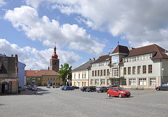
| image_skyline | Benfoto-přibyslav141.jpg |
| image_caption | Town square |
| image_flag | Pribyslav CZ flag.svg |
| image_shield | Znak města Přibyslav hires.svg |
| subdivision_type | Country |
| subdivision_name | |
| subdivision_type1 | Region |
| subdivision_name1 | Vysočina |
| subdivision_type2 | District |
| subdivision_name2 | Havlíčkův Brod |
| pushpin_map | Czech Republic |
| pushpin_relief | 1 |
| pushpin_map_caption | Location in the Czech Republic |
| coordinates | |
| leader_title | Mayor |
| leader_name | Martin Kamarád |
| leader_party | |
| established_title | First mentioned |
| established_date | 1257 |
| area_total_km2 | 35.32 |
| elevation_m | 475 |
| population_as_of | 2025-01-01 |
| population_footnotes | |
| population_total | 4076 |
| population_density_km2 | auto |
| timezone1 | CET |
| utc_offset1 | +1 |
| timezone1_DST | CEST |
| utc_offset1_DST | +2 |
| postal_code_type | Postal code |
| postal_code | 582 22 |
| website | |
| :: |
| name = Přibyslav | other_name = | settlement_type = Town | image_skyline = Benfoto-přibyslav141.jpg | image_caption = Town square | image_flag = Pribyslav CZ flag.svg | image_shield = Znak města Přibyslav hires.svg | subdivision_type = Country | subdivision_name = | subdivision_type1 = Region | subdivision_name1 = Vysočina | subdivision_type2 = District | subdivision_name2 = Havlíčkův Brod | image_map = | map_caption = | pushpin_map = Czech Republic | pushpin_relief = 1 | pushpin_map_caption = Location in the Czech Republic | coordinates = | coordinates_footnotes = | leader_title = Mayor | leader_name = Martin Kamarád | leader_party = | established_title = First mentioned | established_date = 1257 | area_footnotes = | area_total_km2 = 35.32 | elevation_footnotes = | elevation_m = 475 | population_as_of = 2025-01-01 | population_footnotes = | population_total = 4076 | population_density_km2 = auto | timezone1 = CET | utc_offset1 = +1 | timezone1_DST = CEST | utc_offset1_DST = +2 | postal_code_type = Postal code | postal_code = 582 22 | area_code_type = | area_code = | website = | footnotes = Přibyslav () is a town in Havlíčkův Brod District in the Vysočina Region of the Czech Republic. It has about 4,100 people. The historic town centre is well preserved and is protected as an urban monument zone.
Administrative division
Přibyslav consists of eight municipal parts (in brackets population according to the 2021 census):
- Přibyslav (2,926)
- Česká Jablonná (101)
- Dobrá (363)
- Dolní Jablonná (97)
- Hřiště (83)
- Poříčí (90)
- Ronov nad Sázavou (110)
- Utín (53)
Etymology
The name of the town was taken from the personal name Přibyslav. It was probably founded by someone named Přibyslav.
Geography
Přibyslav is located about 11 km east of Havlíčkův Brod and 21 km northeast of Jihlava. It lies in the Upper Sázava Hills. The highest point is a hill at 592 m above sea level. The town is situated on the right bank of the Sázava River. There are several fishponds in the municipal territory, supplied by brooks that flow into the Sázava.
Climate
|width = auto |location = Přibyslav (1991–2020) |metric first = yes |single line = yes |collapsed = yes |Jan record high C = 15.4 |Feb record high C = 15.6 |Mar record high C = 23.0 |Apr record high C = 26.0 |May record high C = 30.5 |Jun record high C = 33.0 |Jul record high C = 34.2 |Aug record high C = 35.8 |Sep record high C = 31.9 |Oct record high C = 24.7 |Nov record high C = 16.1 |Dec record high C = 12.6 |year record high C = 35.8 |Jan high C = 0.5 |Feb high C = 2.4 |Mar high C = 7.0 |Apr high C = 13.0 |May high C = 17.5 |Jun high C = 20.8 |Jul high C = 23.2 |Aug high C = 23.3 |Sep high C = 17.6 |Oct high C = 11.6 |Nov high C = 5.4 |Dec high C = 1.0 |year high C = 11.9 |Jan mean C = -2.0 |Feb mean C = -1.0 |Mar mean C = 2.6 |Apr mean C = 7.8 |May mean C = 12.4 |Jun mean C = 15.8 |Jul mean C = 17.6 |Aug mean C = 17.5 |Sep mean C = 12.7 |Oct mean C = 7.7 |Nov mean C = 3.1 |Dec mean C = -1.1 |year mean C = 7.8 |Jan low C = -4.7 |Feb low C = -4.2 |Mar low C = -1.1 |Apr low C = 2.6 |May low C = 6.9 |Jun low C = 10.0 |Jul low C = 11.7 |Aug low C = 11.7 |Sep low C = 8.1 |Oct low C = 4.3 |Nov low C = 0.6 |Dec low C = -3.4 |year low C = 3.5 |Jan record low C = -25.1 |Feb record low C = -23.6 |Mar record low C = -17.9 |Apr record low C = -9.6 |May record low C = -4.2 |Jun record low C = -1.7 |Jul record low C = 2.5 |Aug record low C = 3.2 |Sep record low C = -2.7 |Oct record low C = -8.6 |Nov record low C = -15.5 |Dec record low C = -26.4 |year record low C = -26.4 |precipitation colour = green |Jan precipitation mm = 42.2 |Feb precipitation mm = 35.8 |Mar precipitation mm = 43.9 |Apr precipitation mm = 35.2 |May precipitation mm = 75.6 |Jun precipitation mm = 75.0 |Jul precipitation mm = 92.7 |Aug precipitation mm = 80.3 |Sep precipitation mm = 59.8 |Oct precipitation mm = 44.2 |Nov precipitation mm = 41.8 |Dec precipitation mm = 42.1 |year precipitation mm = 668.6 |unit precipitation days = 1.0 mm |Jan precipitation days = 9.7 |Feb precipitation days = 8.3 |Mar precipitation days = 10.1 |Apr precipitation days = 7.0 |May precipitation days = 10.5 |Jun precipitation days = 10.1 |Jul precipitation days = 11.1 |Aug precipitation days = 9.3 |Sep precipitation days = 8.3 |Oct precipitation days = 8.5 |Nov precipitation days = 8.7 |Dec precipitation days = 10.1 |year precipitation days = 111.7 |Jan sun = 52.6 |Feb sun = 79.8 |Mar sun = 128.8 |Apr sun = 190.5 |May sun = 220.3 |Jun sun = 221.4 |Jul sun = 237.3 |Aug sun = 234.2 |Sep sun = 164.8 |Oct sun = 107.7 |Nov sun = 46.7 |Dec sun = 41.1 |year sun = 1725.2 |source=NOAA}}
History
The first written mention of Přibyslav is from 1257. Until the Hussite Wars, it was a small mining town known for silver mining. After the wars, the mining was never successfully renewed. During the Hussite Wars, Přibyslav was a military base of the Hussites. The town was often severely affected by wars and by frequent fires, which destroyed many historically valuable buildings. The most devastating fire occurred in 1767.
Demographics
|align=none|cols=3 |1869|3857 |1880|4088 |1890|4009 |1900|4086 |1910|4200 |1921|3859 |1930|3732 |1950|3933 |1961|3953 |1970|3893 |1980|4049 |1991|4028 |2001|3982 |2011|3864 |2021|3823 |source=Censuses}}
Economy
The largest employer based in the town is ACO Industries, a manufacturer of drainage systems. It employs more than 500 people.
Transport
::figure[src="https://upload.wikimedia.org/wikipedia/commons/5/5e/Přibyslav,_train_station_3.jpg" caption="Train station"] ::
The I/19 road (the section from Havlíčkův Brod to Žďár nad Sázavou) runs through the town.
Přibyslav is located on an important railway line heading from Prague to Brno.
Sights
::figure[src="https://upload.wikimedia.org/wikipedia/commons/7/7f/Benfoto-přibyslav042.jpg" caption="The tower with the church"] ::
The oldest building in the town is a Gothic tower from 1497. Next to the tower is the Church of the Nativity of Saint John the Baptist, built in the Baroque style in 1753.
Přibyslav Castle was built in 1560 by Zachariáš of Hradec. There are two courtyards in the castle. The older one is valuable by columns in the Tuscan style. Today the castle houses the Fireman Museum.
An equestrian statue of Jan Žižka by Bohumil Kafka from 1935 is located in the town park. It is a smaller model of the larger statue, which is part of the National Monument at Vítkov in Prague.
Notable people
- Jan Otto (1841–1916), publisher and bookseller
- Josef Reinsberg (1844–1930), physician
- Jan Filip (1911–1971), priest, writer and Esperantist
- Jan Bechyně (1920–1973), entomologist
- Jaromír Málek (1943–2023), Egyptologist
- Hana Orgoníková (1946–2014), politician
Twin towns – sister cities
Přibyslav is twinned with:
- NED Mook en Middelaar, Netherlands
- SVK Sliač, Slovakia
References
References
- (2025-05-16). "Population of Municipalities – 1 January 2025". [[Czech Statistical Office]].
- (2022). "Public Census 2021 – basic data". [[Czech Statistical Office]].
- Profous, Antonín. (1951). "Místní jména v Čechách III: M–Ř".
- "World Meteorological Organization Climate Normals for 1991-2020 — Přibyslav". National Oceanic and Atmospheric Administration.
- "Historie města". Město Přibyslav.
- (2015-12-21). "Historický lexikon obcí České republiky 1869–2011". [[Czech Statistical Office]].
- (2021-03-27). "Population Census 2021: Population by sex". [[Czech Statistical Office]].
- "Registr ekonomických subjektů". Czech Statistical Office.
- "Detail stanice Přibyslav". [[České dráhy]].
- "Historické památky". Město Přibyslav.
- "Partnerská města". Přibyslav.
::callout[type=info title="Wikipedia Source"] This article was imported from Wikipedia and is available under the Creative Commons Attribution-ShareAlike 4.0 License. Content has been adapted to SurfDoc format. Original contributors can be found on the article history page. ::