Oca (river)
River in Spain
title: "Oca (river)" type: doc version: 1 created: 2026-02-28 author: "Wikipedia contributors" status: active scope: public tags: ["rivers-of-spain", "ebro-basin", "rivers-of-burgos", "rivers-of-castile-and-león"] description: "River in Spain" topic_path: "geography/spain" source: "https://en.wikipedia.org/wiki/Oca_(river)" license: "CC BY-SA 4.0" wikipedia_page_id: 0 wikipedia_revision_id: 0
::summary River in Spain ::
::data[format=table title="Infobox river"]
| Field | Value |
|---|---|
| name | Oca |
| name_other | |
| image | Río Oca.JPG |
| image_size | 250px |
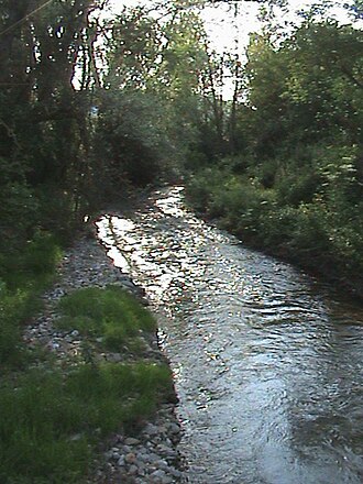
| image_caption | Watershed of the Oca at Villalbos (Valle de Oca) |
| map | Valle del Ebro.jpg |
| map_size | 350 |
| map_caption | Oca river is the first Ebro tributary river on the right bank |
| pushpin_map | Spain Castile and León#Spain |
| pushpin_map_size | 350 |
| pushpin_map_caption | Location of the mouth with Castile and León |
| subdivision_type1 | Country |
| subdivision_name1 | Spain |
| length | 70 km |
| source1 | Montes de Oca |
| source1_location | Rábanos, Montes de Oca, Burgos, Castile and León, Spain |
| source1_elevation | 1186 m |
| mouth | Horadada Gorge, Ebro river |
| mouth_location | Oña, La Bureba, Burgos, Castile and León, Spain |
| mouth_coordinates | |
| mouth_elevation | 570 m |
| progression | |
| tributaries_left | Cerratón, Anguilas, Homino |
| tributaries_right | Matapán |
| :: |
| name = Oca | name_native = | name_native_lang = | name_other = | name_etymology = | image = Río Oca.JPG | image_size = 250px | image_caption = Watershed of the Oca at Villalbos (Valle de Oca) | map = Valle del Ebro.jpg | map_size = 350 | map_caption = Oca river is the first Ebro tributary river on the right bank | pushpin_map = Spain Castile and León#Spain | pushpin_map_size = 350 | pushpin_map_caption= Location of the mouth with Castile and León | subdivision_type1 = Country | subdivision_name1 = Spain | subdivision_type2 = | subdivision_name2 = | subdivision_type3 = | subdivision_name3 = | subdivision_type4 = | subdivision_name4 = | subdivision_type5 = | subdivision_name5 = | length = 70 km | width_min = | width_avg = | width_max = | depth_min = | depth_avg = | depth_max = | discharge1_location= | discharge1_min = | discharge1_avg = | discharge1_max = | source1 = Montes de Oca | source1_location = Rábanos, Montes de Oca, Burgos, Castile and León, Spain | source1_coordinates= | source1_elevation = 1186 m | mouth = Horadada Gorge, Ebro river | mouth_location = Oña, La Bureba, Burgos, Castile and León, Spain | mouth_coordinates = | mouth_elevation = 570 m | progression = | river_system = | basin_size = | tributaries_left = Cerratón, Anguilas, Homino | tributaries_right = Matapán | custom_label = | custom_data = | extra = The Oca river is a short river, about 70 km long, in the north of Spain. It is an affluent of the Ebro river that flows through the province of Burgos. It begins in the Sistema Ibérico range and flows north through the municipalities of Rábanos, Villafranca Montes de Oca, Valle de Oca, Alcocero de Mola, Prádanos de Bureba, Briviesca, Vileña, the shire of Bureba and Oña.
The Oca River rises in the comarca of Montes de Oca, near the town of Rábanos. Near its source, the river passes through the narrow, rock-lined gorge of La Hoz. This passage, 700 m long and 100 m high, was of great strategic value in the 11th century and was defended by the castle of Alba.
Affluents
From the right, the Oca receives the waters of the river Matapán and the streams Valsorda and Penches, while on the left it receives the waters of the rivers Cerratón, Anguilas and Homino, and the streams Valdazo and Hoyo.
References
::callout[type=info title="Wikipedia Source"] This article was imported from Wikipedia and is available under the Creative Commons Attribution-ShareAlike 4.0 License. Content has been adapted to SurfDoc format. Original contributors can be found on the article history page. ::