Ngaliema
title: "Ngaliema" type: doc version: 1 created: 2026-02-28 author: "Wikipedia contributors" status: active scope: public tags: ["communes-of-kinshasa", "ngaliema"] topic_path: "general/communes-of-kinshasa" source: "https://en.wikipedia.org/wiki/Ngaliema" license: "CC BY-SA 4.0" wikipedia_page_id: 0 wikipedia_revision_id: 0
::data[format=table title="Infobox settlement"]
| Field | Value |
|---|---|
| name | Ngaliema |
| official_name | Commune de Ngaliema |
| type | Commune |
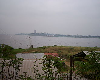
| image_skyline | Ngaliema bay.jpg |
| imagesize | 280px |
| image_caption | Ngaliema Bay |
| mapsize1 | 270 |
| mapframe | yes |
| mapframe-custom | {{maplink |
| frame | yes |
| plain | yes |
| frame-align | center |
| frame-width | 270 |
| frame-height | 250 |
| frame-coordinates | SWITCH:### |
| zoom | SWITCH:11,8 |
| type | shape-inverse |
| fill | #AAAAAA |
| stroke-width | 1 |
| stroke-color | #777777 |
| id | Q3838 |
| title | Shaded areas are outside Kinshasa city-province. |
| type2 | line |
| stroke-width2 | SWITCH:4,2 |
| id2 | Q3339269 |
| title2 | Ngaliema Border |
| switch | city center, city-province |
| mapframe-caption | Ngaliema on map of Kinshasa city-province |
| pushpin_map | Democratic Republic of the Congo |
| pushpin_map_caption | Location in DR Congo |
| coordinates | |
| coordinates_footnotes | {{cite web |
| url | https://maps.google.com/maps/place?ftid=0x1a6a31bb149a2299:0xcd21dd79837324a |
| title | Ngaliema, Kinshasa, Democratic Republic of the Congo |
| publisher | Google Maps |
| access-date | 20 August 2011 |
| subdivision_type | Country |
| subdivision_name | DR Congo |
| subdivision_type1 | City-Province |
| subdivision_name1 | Kinshasa |
| area_total_km2 | 224.3 |
| population_as_of | 2015 est. |
| population_total | 2025942 |
| population_density_km2 | auto |
| :: |
| name = Ngaliema | official_name = Commune de Ngaliema | type = Commune | image_skyline = Ngaliema bay.jpg | imagesize = 280px | image_caption = Ngaliema Bay | image_map = | map_caption = | image_map1 = | map_caption1 = | mapsize1 = 270 | mapframe = yes | mapframe-custom = {{maplink | frame = yes | plain = yes | frame-align = center | frame-width = 270 | frame-height = 250 | frame-coordinates = SWITCH:### | zoom = SWITCH:11,8 | type = shape-inverse | fill = #AAAAAA | stroke-width = 1 | stroke-color = #777777 | id = Q3838 | title = Shaded areas are outside Kinshasa city-province. | type2 = line | stroke-width2 = SWITCH:4,2 | id2 = Q3339269 | title2 = Ngaliema Border | switch = city center, city-province | mapframe-caption = Ngaliema on map of Kinshasa city-province | pushpin_map = Democratic Republic of the Congo | pushpin_label_position = | pushpin_map_caption = Location in DR Congo | coordinates = | coordinates_footnotes = {{cite web | url = https://maps.google.com/maps/place?ftid=0x1a6a31bb149a2299:0xcd21dd79837324a | title = Ngaliema, Kinshasa, Democratic Republic of the Congo | publisher = Google Maps | access-date = 20 August 2011 | subdivision_type = Country | subdivision_name = DR Congo | subdivision_type1 = City-Province | subdivision_name1 = Kinshasa | area_footnotes = | area_total_km2 = 224.3 | elevation_footnotes = | elevation_m = | population_footnotes = | population_as_of = 2015 est. | population_total = 2025942 | population_density_km2 = auto
Ngaliema is a commune in the Lukunga District of Kinshasa. Covering an area of approximately 224.3 square kilometers, it is one of the largest communes in the city and had an estimated population of 2,025,942 as of 2015.**** Established on 12 October 1957, Ngaliema was officially delineated by Ministerial Decree No. 69-042 of 23 January 1969 and is currently governed under Decree-Laws No. 82-006 and 82-008 of 29 January 1982, which define the administrative and political organization of the country and the status of Kinshasa.
The commune is composed of 21 quartiers (neighborhoods) and is bordered by the Republic of the Congo to the north, Mont-Ngafula to the south and southeast, Kintambo and Gombe to the east, and the Congo and Lukunga Rivers to the west. Its name originates from a Brazzaville native, Ngaliema, who settled in the area after defeating a local chief, Lingwala, prior to the arrival of the Welsh-American explorer Henry Morton Stanley.
Geography
Ngaliema is situated within a landscape of hills and valleys, featuring some of the highest elevations in western Kinshasa. The terrain is marked by significant erosion in certain areas. The commune's boundaries are largely defined by natural and infrastructural landmarks. To the north, Ngaliema borders the Republic of the Congo along the Congo River, extending from the confluence with the Lukunga River to the confluence with the Gombe River. From this point, a straight boundary line separates it from the commune of Gombe. The northern boundary continues along a high-voltage power line toward the western edge of the Colonel Kokolo Military Camp, proceeding past the Bandalungwa River and a railway intersection near Sport Street. The western boundary follows the Lukunga River southward until it meets the Congo River, forming a straight-line border. To the south, the boundary extends toward the Bikela River, following it to its confluence with the Lukunga River in the Mont-Ngafula commune. The eastern border runs along Kikwit Avenue to the Lubudi River, then upstream to its source, continuing by a straight line south to Laurent-Désiré Kabila Avenue and connecting with the source of the Bikela River.
Hydrography and soils
| image1 = Les rochers.jpg | image2 = Pierres au bord du fleuve Congo dans la commune de Ngaliema.jpg | align = left | footer_align = center | footer = The rocks on the bank of the Congo River from Kinsuka-Pêcheur quartier in Ngaliema | direction = vertical | total_width = 220 Ngaliema's hydrographic network is primarily composed of boundary-defining rivers, rather than internal waterways. The most prominent rivers include the Lukunga, the Binza, and the Makelele, each of which forms natural borders with adjacent communes. These rivers are integral to the region's drainage system, particularly during the rainy season, when heavy downpours intensify flooding and erosion.
The soil composition across Ngaliema is predominantly a mix of clay and sand, with notable variation depending on the topography. Certain zones are characterized by heavier clay content, showing greater water retention, while others are dominated by more porous and less stable sandy soils.
Climate
Ngaliema experiences a typical equatorial tropical climate, typified by high humidity and persistently warm temperatures throughout the year. The climatic cycle is split into two primary seasons: a rainy season and a dry season. The rainy season spans roughly eight months, from mid-September to mid-May, and is characterized by intense and frequent rainfall that contributes to soil degradation and the swelling of rivers. The dry season, lasting from mid-May to mid-September, brings a marked decline in precipitation and a modest reduction in humidity levels. Nevertheless, temperatures remain relatively constant year-round.
Due to its steep slopes, weak sandy soils, and prolonged wet periods, Ngaliema is particularly prone to erosion. Large gullies and ravines, some of which pose threats to residential areas, roads, and public infrastructure, are a recurring issue. This environmental vulnerability is also aggravated by rapid, often unregulated urban expansion, deforestation on hillsides, and inadequate drainage infrastructure.
Administrative structure and governance
Ngaliema, like all communes within Kinshasa, functions as a decentralized territorial entity (entité territoriale décentralisée, ETD) possessing legal personality and administrative autonomy. Its governance structure is centered on two principal bodies: the Conseil Communal (Communal Council) and the Collège Exécutif Communal (Communal Executive College).
The Conseil Communal serves as the commune's deliberative assembly. It is composed of members known as conseillers communaux, who are elected by direct universal suffrage. The council's responsibilities include debating and deciding on matters of communal interest across economic, social, cultural, and technical sectors. It also elects the bourgmestre (mayor) and deputy mayor through indirect suffrage and oversees the implementation of policies and programs executed by the commune's executive branch.
The Collège Exécutif Communal, led by the bourgmestre and assisted by the deputy mayor, acts as the executive organ responsible for the daily administration of the commune. It also includes two échevins communaux (aldermen), appointed based on competence, credibility, and community representation. This body executes decisions adopted by the council and manages local governance under the broader authority of the Governor of Kinshasa.
Administratively, Ngaliema is divided into 21 quartiers (neighborhoods), which are further subdivided into avenues. The size and layout of these quartiers vary, with planned urban quartiers generally following a formal grid pattern, while semi-urban or informal areas tend to be larger and form part of Kinshasa's urban sprawl. Each quartier is managed by a local administration composed of a chef de quartier (neighborhood chief), deputy, secretary, population officer, and a team of enumerators (agents recenseurs). These officials are appointed by the Governor of Kinshasa. ::data[format=table]
| No. | Quartiers (neighborhoods) |
|---|---|
| 1. | Lukunga |
| 2. | Ngomba Kikusa |
| 3. | Bumba |
| 4. | Binza-Pigeon |
| 5. | Djelo Binza |
| 6. | Bangu |
| 7. | Punda |
| 8. | Kimpe |
| 9. | Anciens Combattants |
| 10. | Basoko |
| 11. | Congo |
| 12. | Joli Parc |
| 13. | Kinkenda |
| 14. | Kinsuka Pêcheur |
| 15. | Lonzo |
| 16. | Musey |
| 17. | Mama-Yemo |
| 18. | Manenga |
| 19. | Mfinda |
| 20. | Monganga |
| 21. | Lubudi |
| :: |
Source: Report from the Commune of Ngaliema (2009)
Economy
| total_width = 210 | image1 = Macampagne ngaliema.jpg | caption1 = Avenue Ma Campagne is a street located in the northeast of Ngaliema | align = left | caption_align = center Ngaliema serves as a residential and industrial hub within Kinshasa, characterized by a mix of upscale quartiers (neighborhoods) and industrial zones. The commune is home to members of the upper bourgeoisie and high-income earners, which makes it one of the city's more affluent areas. Many of its quartiers are mixed-use, where factories coexist alongside well-developed residential areas, connected by a network of paved roads. However, the commune also bears traces of unregulated urban expansion, especially in the aftermath of Congolese independence in 1960. Spontaneous settlements emerged in areas unsuitable for construction, such as hillsides, wetlands, and flood zones, often in violation of urban planning laws. This disorderly urbanization was driven by several factors, including the sudden exodus of colonial administrators, unauthorized land sales by traditional chiefs and local officials, the instability of the post-independence civil war, and rapid rural-to-urban migration. The resulting housing crisis accelerated the creation of informal settlements such as Kinsuka Pêcheurs quartier.
| total_width = 220 | image1 = MARCHAND 01.jpg | caption1 = Gravel trade along Avenue du Tourisme in Ngaliema | caption_align = center
In addition to its residential and industrial functions, Ngaliema contributes to Kinshasa's urban agriculture through its involvement in the Green Belt and Presidential Valleys (Ceintures Vertes et Vallées Présidentielles; CVVP) program, launched in 1972 as part of a broader governmental initiative to promote food security and urban horticulture. This initiative sought to develop productive agricultural zones around Kinshasa, including areas within Ngaliema. The Lukunga site, located in the Lukunga quartier, became a focal point for market gardening activities in the commune. The program was supported by French cooperation and institutionalized through the establishment of CECOMAF (Centre de Coopération Maraîchère de Kinshasa), an organization tasked with land management, infrastructure oversight, and the dissemination of modern agricultural techniques. Although CECOMAF faced limitations in product commercialization, it facilitated the organization of over 8,000 market gardeners into 12 cooperatives. These cooperatives focus primarily on cultivating fast-growing crops, such as amaranth (biteku-teku), sweet potato leaves (matembele), roselle (ngai-ngai), spinach, and chives, which are staples in the diet of Kinshasa residents.
Tourism
| total_width = 350 | image1 = Chapelle missionnaire CBCO Sims.jpg | caption1 = Sims Chapel, located on Avenue de l'Avenir in the Basoko quartier (neighborhood) of Ngaliema, is the first Christian building ever constructed in the city. | image2 = Eglise Saint Léopold.jpg | caption2 = Saint-Léopold catholic parish in Ngaliema | caption_align = center Ngaliema is the most ancient and historically significant commune in the city. As the site where Welsh-American explorer Henry Morton Stanley first established an encampment that later evolved into modern-day Kinshasa, Ngaliema features several heritage landmarks and scenic locations, with its strategic position along the Congo River offering visitors panoramic views of Ngaliema Bay and the Kinsuka Rapids.
The commune is home to several significant cultural and historical attractions. Among these landmarks are Sims Chapel (1891), established by Reverend Aaron Sims of the American Baptist Foreign Mission Society and considered the first Christian structure in Kinshasa; the Saint-Léopold catholic parish, founded in 1899; and the Institute of National Museums of Congo, which preserves and exhibits national artifacts and historical collections.
| total_width = 160 | image1 = F Theatre de verdure Ngaliema.jpg | caption1 = The Théâtre de la Verdure in 1974 | caption_align = center | align = left
The Marble Palace, originally a guest residence during Mobutu Sese Seko's regime and later the official presidential residence under Laurent-Désiré Kabila, is located within the commune. Nearby is the Colonel Tshatshi Military Camp, a military complex housing the Ministry of Defense and the joint Chief of Staff of the Armed Forces of the Democratic Republic of the Congo (FARDC), as well as a Republican Guard military hospital. Adjacent to the camp is the traditional presidential residence, situated on Mount Ngaliema (formerly Mount Stanley during the colonial era) initially used as the residence of the governor of the former Léopoldville. Following Congolese independence in 1960, the site became the residence of the Republic's first president, Joseph Kasa-Vubu. In 1966, under President Mobutu, the site was renamed Mont Ngaliema and redeveloped as a Parc Présidentiel (Presidential Park), with landscaping and garden designs by the Franco-Tunisian architect Olivier-Clément Cacoub. The park was adorned with statues of historical figures such as Leopold II of Belgium and Henry Morton Stanley, and featured the Théâtre de la Verdure, an open-air amphitheater modeled on classical Greco-Roman designs, completed in 1970. The presidential palace and surrounding complex were subject to extensive looting in 1997, following the collapse of the Mobutu regime during the First Congo War. Ngaliema also contains the African Union City, a complex established in September 1967 to host heads of state attending the Organization of African Unity (OAU) summit held in Kinshasa.
| total_width = 220 | image1 = PHOT DU JOUR DU JEUDI 7 OCTOBRE 2021.jpg | caption1 = African Union City | caption_align = center
Other notable sites include the Cimetière des Pionniers (Pioneers' Cemetery) and remnants of colonial infrastructure such as the original shipyard and port, as well as the Kintambo-Magasins commercial center.
Ngaliema is home to the terminus of an old caravan route and communal buildings, which were originally constructed in 1930 as the first hospital for Europeans in the region. The commune also showcases artisanal craftsmanship through furniture workshops using kekele liana, along with natural attractions known as the Symphonies Naturelles.
Demographics
Population and languages
Ngaliema has experienced significant demographic growth over the past two decades. In 2005, the population was estimated at 518,821 inhabitants, increasing to 555,770 by 2008. {{Demography | 1967 = | 1970 = | 1984 = | 2003 = | 2004 = ::data[format=table]
| No. | Quartiers (neighborhoods) | Population (2009 est) |
|---|---|---|
| 1. | Lukunga | 35,720 |
| 2. | Ngomba Kikusa | 27,542 |
| 3. | Bumba | 38,435 |
| 4. | Binza-Pigeon | 39,197 |
| 5. | Djelo Binza | 17,618 |
| 6. | Bangu | 12,845 |
| 7. | Punda | 20,386 |
| 8. | Kimpe | 15,783 |
| 9. | Anciens Combattants | 22,686 |
| 10. | Basoko | 8,342 |
| 11. | Congo | 19,591 |
| 12. | Joli Parc | 1,859 |
| 13. | Kinkenda | 4,166 |
| 14. | Kinsuka Pêcheur | 2,690 |
| 15. | Lonzo | 24,475 |
| 16. | Musey | 28,608 |
| 17. | Mama-Yemo | 3,569 |
| 18. | Manenga | 31,802 |
| 19. | Mfinda | 3,837 |
| 20. | Monganga | 28,185 |
| 21. | Lubudi | 2,344 |
| :: |
Source: Report from the Commune of Ngaliema (2009)
By 2015, the number of residents had risen sharply to an estimated 2,025,942, making Ngaliema one of the most densely populated and rapidly growing communes in the capital.
The commune is linguistically diverse, with Lingala serving as the most widely spoken language in daily communication and urban life. French, the official language of the Democratic Republic of the Congo, is used in administration, education, and formal settings. Tshiluba and Kikongo are also commonly spoken among communities originating from other regions of the country.
Religion
Religious affiliation in Ngaliema is marked by a mix of traditional Christian denominations and newer revivalist movements. The principal faith communities include the Roman Catholic Church, Protestant churches, and the Kimbanguist Church. In recent decades, however, revival or "églises de réveil" (born-again churches) have gained widespread popularity, attracting large followings despite the longstanding presence of traditional churches.
Education
Ngaliema is home to a wide array of educational institutions, ranging from preschool to university level. Among its notable schools is the American School of Kinshasa (TASOK), one of the leading international schools in the country, and the public Université Pédagogique Nationale, the DRC's first pedagogical university. Other private institutions include the Ecole Internationale Bilingue le Cartésien and the Groupe Scolaire Aurore-Matanelo, the latter of which operates campuses in Ngaliema and Limete, offering primary, secondary, and humanities education. The commune also hosts several public and religious institutions, including the Bobokoli Institute, entrusted to the Marist Brothers, which was initially established as a primary school but expanded to secondary education in 1973. Although its literature section was transferred to Collège Boboto shortly thereafter, the institute specialized in the sciences and, over time, introduced specialized streams such as mathematics and physics for boys and girls.
Other significant establishments include the Lycée Tobongisa, Complexe Scolaire Mafuta, Collège Don Bosco de Lukunga, and Collège Saint Cyprien primary school. The commune also hosts the Institut Technique Professionnel Ngaliema (ITP), which traces its roots back to 1920, when it was founded as a vocational school. It later evolved into the Centre de Spécialisation Professionnelle (CSP) before being restructured as ITP in 2000. Ngaliema also serves as the headquarters of the Group of Military Higher Schools (GESM).
Embassies
The French Embassy in the Democratic Republic of the Congo is located in the northern part of the commune, at 1 Colonel Mondjiba Avenue, in the Basoko quartier, near the border with Gombe.
The Lebanese Embassy is located in the Joli Parc quartier, Ma Campagne, at 19 Joli Parc Avenue.
References
References
- (2015). "Monographie de la ville de Kinshasa". Institut Congolais de Recherche en Développement et Etudes Stratégiques (ICREDES).
- Sukisa, Maspy Yeta. (2008). "La pression de l'habitat sur le site maraicher de Lukunga dans la commmune de Ngaliema a Kinshasa: problématique de planification urbaine et pistes d'aménagement". [[University of Kinshasa]].
- "''Géographie de Kinshasa'' (Geography of Kinshasa)". Ville de Kinshasa (City of Kinshasa).
- (10 October 2022). "Le développement de la commune de Ngaliema au centre de la célébration du 65ème anniversaire de cette municipalité".
- Nzuzi, Francis Lelo. (2008). "Kinshasa: ville et environnement". Editions L'Harmattan.
- (11 April 2024). "Lutte contre les érosions en RDC : quelles sont les bonnes stratégies?".
- (1 August 2024). "Kinshasa: à Ngaliema, ces têtes d'érosions qui ont déjà englouti des maisons et ne cessent de progresser (photoreportage)".
- Imwangana, Fils Makanzu. (2010). "Etude de l'érosion ravinante à Kinshasa par télédétection et SIG (système d'information géographique) entre 1957 et 2007". [[University of Liège]].
- Wouters, Thomas. (1 October 2010). "Contribution à l'analyse de l'érosion intra-urbaine à Kinshasa (R.D.C.)". Revue belge de géographie.
- (2015). "Monographie de la ville de Kinshasa". Institut Congolais de Recherche en Développement et Etudes Stratégiques (ICREDES).
- Sukisa, Maspy Yeta. (2008). "La pression de l'habitat sur le site maraicher de Lukunga dans la commmune de Ngaliema a Kinshasa: problématique de planification urbaine et pistes d'aménagement". [[University of Kinshasa]].
- Ilunga, Aristarque. (2015). "Promouvoir les atouts touristiques de la ville de Kinshasa à l'ère des terminaux mobiles". [[University of Picardy Jules Verne]].
- Mboka, Mwana. (4 May 2016). "Kinshasa Then and Now: Leopoldville 1891 - Dr. Sims builds a Chapel".
- Rabuni, Popol. (20 April 2024). "Palais de Marbre: 12 ans depuis que Kabila interdit son survol!".
- (17 January 2021). "Vif engouement de la population au Mémorial Mzee Laurent Désiré Kabila au Palais de marbre".
- Kouadio, Jean-Francois. (2017-10-26). "La Republique des singes". African Books Collective.
- Kitzita, Jephthah. (9 April 2023). "RDC: Félix Tshisekedi inaugure le nouvel hôpital militaire de la Garde Républicaine situé au Camp Tshatshi".
- Bayo, Herman Bangi. (2 July 2020). "Mont Ngaliema: musée en plein air…".
- Beurden, Sarah Van. (25 November 2015). "Authentically African: Arts and the Transnational Politics of Congolese Culture". [[Ohio University Press]].
- United States House Appropriations Subcommittee on State, Foreign Operations, and Related Programs. (1975). "Foreign Assistance and Related Agencies Appropriations for 1976: Hearings Before a Subcommittee of the Committee on Appropriations, House of Representatives, Ninety-fourth Congress, First Session". U.S. Government Printing Office.
- (1973). "Central & Southern Africa Series: Volume 17, Issue 1". American Universities Field Staff..
- (20 April 2022). "Why Art Criticism? A Reader". Hatje Cantz Verlag.
- Morice, Florence. (27 January 2019). "RDC: où loger le nouveau président de la République congolaise F. Tshisekedi?".
- Decraene, Philippe. (1 October 1967). "A Kinshasa les dirigeants de l'O.U.A. ont réaffirmé leur solidarité".
- Nagel, R.. (1967). "The OAU at Kinshasa". [[Chatham House]].
- (28 January 2019). "Le Président Félix Tshisekedi installé à la cité de l'UA".
- Laporte, Christian. (30 June 2010). "Le Roi sur les traces d'Albert Ier et de Stanley".
- (29 June 2010). "Le roi Albert II au chantier de Chanic sur les traces de Stanley".
- Sukisa, Maspy Yeta. (2008). "La pression de l'habitat sur le site maraicher de Lukunga dans la commmune de Ngaliema a Kinshasa: problématique de planification urbaine et pistes d'aménagement". [[University of Kinshasa]].
- Ngwakonde, Marcel Luboya. (2014). "Implication des couples mariés dans la planification familiale". [[Université Pédagogique Nationale]].
- "[http://www.tasok.net/ Home]." [[American School of Kinshasa]]. Retrieved on 8 December 2017. "The American School of Kinshasa Rte de Matadi, Ngaliema Kinshasa II, République Démocratique du Congo"
- "The American School of Kinshasa (TASOK): About Us". [[American School of Kinshasa]].
- (24 August 2020). "Au Top 10 des meilleures écoles privées de Kinshasa, Le Cartésien arrive en tête".
- "Groupe Scolaire Aurore Matanelo: Toujours Mieux".
- (28 August 2025). "Histoire de l'Institut Bobokoli". Bobokoli Institute.
- (6 May 2024). "L'Eglise de Jésus-Christ des Saints des Derniers Jours rénove une école Catholique à Kinshasa en République Démocratique du Congo.- "C'est un Miracle!"".
- Kapinga, Francine. (24 June 2014). "Congo-Kinshasa: Centre des examens d'Etat Tobongisa - Première journée, les finalistes satisfaits de leur prestation".
- Diawaku, Perside. (27 March 2017). "Congo-Kinshasa: Les lycéennes de "Tobongisa" face aux hauts faits de leurs aînées".
- Tshimueneka, Nancy Clémence. (11 November 2024). "Kinshasa: sensibilisation aux violences basées sur le genre au lycée Tobongisa".
- Nl-Ns, Fl. (29 March 2013). "Congo-Kinshasa: Ngaliema - Les cambrioleurs du Complexe scolaire Mafuta provoquent la mort du veilleur de nuit".
- (21 August 2025). "Ecoles et familles de Kinshasa mobilisées pour la rentrée scolaire du 1er septembre".
- (18 March 2024). "Collège Don Bosco de Lukunga: Visite du Père Provincial". Collège Don Bosco de Lukunga.
- (27 June 2024). "Kinshasa: Associations mouvement jaune et la fondakamp recompasent enseignant et élèves du collège Don Bosco Lukunga".
- (20 January 2023). "L'EP Saint Cyprien n'a jamais exigé 20$ aux finalistes du primaire".
- (12 May 2025). "Éducation: deux écoles de Kinshasa bénéficiaires des bancs pupitres".
- Nl-Ns, Fl. (24 February 2011). "Congo-Kinshasa: Créé en 1920 comme un centre d'aptitude professionnelle - L'ITP/Ngaliema: quatre-vingt-onze ans au service de la jeunesse congolaise".
- (5 July 2012). "Congo-Kinshasa: ITP/Ngaliema benefits from a Landmark Jeep".
- Tshiambi, Albert. (27 November 2010). "Congo-Kinshasa: Soixante officiers FARDC en formation au GESM".
- (18 January 2012). "Congo-Kinshasa: 57 officiers des FARC formés à l'école d'administration".
- "Congo (République démocratique)". [[Government of France]].
- "Liban: Ambassade Liban à Kinshasa".
::callout[type=info title="Wikipedia Source"] This article was imported from Wikipedia and is available under the Creative Commons Attribution-ShareAlike 4.0 License. Content has been adapted to SurfDoc format. Original contributors can be found on the article history page. ::