Myall River
River in New South Wales, Australia
title: "Myall River" type: doc version: 1 created: 2026-02-28 author: "Wikipedia contributors" status: active scope: public tags: ["rivers-of-new-south-wales", "mid-coast-council", "mid-north-coast", "rivers-of-the-hunter-region"] description: "River in New South Wales, Australia" topic_path: "geography/united-kingdom" source: "https://en.wikipedia.org/wiki/Myall_River" license: "CC BY-SA 4.0" wikipedia_page_id: 0 wikipedia_revision_id: 0
::summary River in New South Wales, Australia ::
::data[format=table title="Infobox river"]
| Field | Value |
|---|---|
| name | Myall River |
| name_other | Upper Myall River |
| name_etymology | Aboriginal: myall, a small silver-grey wattle tree |
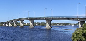
| image | Singing Bridge.JPG |
| image_caption | Singing Bridge across the Myall River at Tea Gardens/Hawks Nest. |
| subdivision_type1 | Country |
| subdivision_name1 | Australia |
| subdivision_type2 | State |
| subdivision_name2 | New South Wales |
| subdivision_type3 | Region |
| subdivision_name3 | NSW North Coast (IBRA), Mid North Coast, Hunter |
| subdivision_type4 | Local government area |
| subdivision_name4 | Mid-Coast Council |
| subdivision_type5 | Town |
| subdivision_name5 | Bulahdelah, Tea Gardens, Hawks Nest |
| length_km | 92 |
| source1 | Kyle Range, Great Dividing Range |
| source1_location | north northeast of Stroud |
| source1_elevation | 352 m |
| mouth | Port Stephens |
| mouth_location | at Hawks Nest |
| mouth_elevation | 0 m |
| river_system | Mid-Coast Council |
| basin_size_km2 | 819 |
| tributaries_left | Kyle Creek, Pipers Creek (Great Lakes, New South Wales) |
| tributaries_right | Crawford River, Little Myall River, Monkey Jacket Creek |
| custom_label | National park |
| custom_data | Myall Lakes NP |
| extra | |
| :: |
| name = Myall River | native_name = | native_name_lang = | name_other = Upper Myall River | name_etymology = Aboriginal: myall, a small silver-grey wattle tree | image = Singing Bridge.JPG | image_size = | image_caption = Singing Bridge across the Myall River at Tea Gardens/Hawks Nest. | map = | map_size = | map_caption = | pushpin_map = | pushpin_map_size = | pushpin_map_caption= | subdivision_type1 = Country | subdivision_name1 = Australia | subdivision_type2 = State | subdivision_name2 = New South Wales | subdivision_type3 = Region | subdivision_name3 = NSW North Coast (IBRA), Mid North Coast, Hunter | subdivision_type4 = Local government area | subdivision_name4 = Mid-Coast Council | subdivision_type5 = Town | subdivision_name5 = Bulahdelah, Tea Gardens, Hawks Nest | length_km = 92 | width_min = | width_avg = | width_max = | depth_min = | depth_avg = | depth_max = | discharge1_location= | discharge1_min = | discharge1_avg = | discharge1_max = | source1 = Kyle Range, Great Dividing Range | source1_location = north northeast of Stroud | source1_coordinates= | source1_elevation = 352 m | mouth = Port Stephens | mouth_location = at Hawks Nest | mouth_coordinates = | mouth_elevation = 0 m | progression = | river_system = Mid-Coast Council | basin_size_km2 = 819 | tributaries_left = Kyle Creek, Pipers Creek (Great Lakes, New South Wales) | tributaries_right = Crawford River, Little Myall River, Monkey Jacket Creek | custom_label = National park | custom_data = Myall Lakes NP | extra =
Myall River, an open semi-mature brackish freshwater barrier estuary of the Mid-Coast Council system, is located in the Mid North Coast region of New South Wales, Australia.
Course and features
Myall River rises out of the southern slopes of Kyle Range within the Great Dividing Range, north northeast of Stroud, and flows generally south southeast then southwest, joined by tributaries, before reaching its mouth within Port Stephens at Hawks Nest. Port Stephens then empties into the Tasman Sea of the South Pacific Ocean. The river descends 355 m over its 92 km course.
After flowing past the town of Bulahdelah, east of the small settlement of Nerong, the Myall River enters the most southern of the three Ramsar-protected Myall Lakes, Bombah Broadwater, within the Myall Lakes National Park. The flow of the river runs adjacent to the coastline and through both the Little Brasswater and the Brasswater near the towns of Tea Gardens, and Hawks Nest.
Two notable bridges cross the Myall River. The Bulahdelah Bridge, carries the Pacific Highway, across the river north of Bulahdelah and the Singing Bridge crosses the river between Tea Gardens and Hawks Nest..
Etymology
The word myall is an Australian Aboriginal term for a small silver-grey wattle tree.
References
References
- (22 February 1974). "Myall River".
- Reed, A. W.. (1973). "Place names of Australia". [[Reed Books]].
- "Map of Myall River, NSW". Bonzle Digital Atlas of Australia.
- (2001). "Structure and Function of South-east Australian Estuaries". [[Estuarine, Coastal and Shelf Science]].
- "Lakes". [[Mid-Coast Council]].
::callout[type=info title="Wikipedia Source"] This article was imported from Wikipedia and is available under the Creative Commons Attribution-ShareAlike 4.0 License. Content has been adapted to SurfDoc format. Original contributors can be found on the article history page. ::