Mount Grace State Forest
Massachusetts state forest
title: "Mount Grace State Forest" type: doc version: 1 created: 2026-02-28 author: "Wikipedia contributors" status: active scope: public tags: ["massachusetts-state-forests", "parks-in-franklin-county,-massachusetts", "warwick,-massachusetts", "civilian-conservation-corps-in-massachusetts", "protected-areas-established-in-1920", "1920-establishments-in-massachusetts"] description: "Massachusetts state forest" topic_path: "technology/web" source: "https://en.wikipedia.org/wiki/Mount_Grace_State_Forest" license: "CC BY-SA 4.0" wikipedia_page_id: 0 wikipedia_revision_id: 0
::summary Massachusetts state forest ::
::data[format=table title="Infobox protected area"]
| Field | Value |
|---|---|
| name | Mount Grace State Forest |
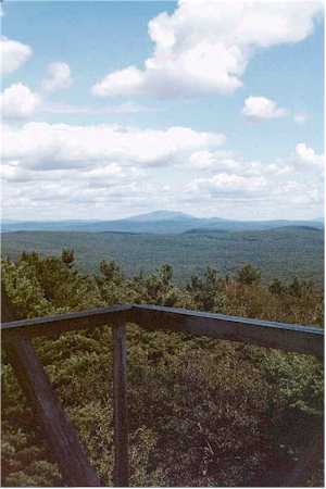
| photo | View of Mount Monadnock from the Mount Grace fire tower.jpg |
| photo_caption | View from the firetower on Mount Grace |
| photo_alt | Landscape |
| map | USA Massachusetts#USA |
| map_size | 280 |
| map_caption | Location in Massachusetts |
| relief | 1 |
| label | Mount Grace State Forest |
| location | Warwick, Massachusetts, United States |
| coordinates | |
| coords_ref | |
| area | 1578 acre |
| area_ref | |
| elevation | 1614 ft |
| established | 1920 |
| administrator | Massachusetts Department of Conservation and Recreation |
| website | |
| :: |
| name = Mount Grace State Forest | photo = View of Mount Monadnock from the Mount Grace fire tower.jpg | photo_caption = View from the firetower on Mount Grace | photo_alt = Landscape | map = USA Massachusetts#USA | map_size = 280 | map_caption = Location in Massachusetts | relief = 1 | label = Mount Grace State Forest | location = Warwick, Massachusetts, United States | nearest_city = | coordinates = | coords_ref = | area = 1578 acre | area_ref = | elevation = 1614 ft | established = 1920 | named_for = | administrator = Massachusetts Department of Conservation and Recreation | visitation_num = | visitation_year = | visitation_ref = | website = | embedded = Mount Grace State Forest is a publicly owned forest with recreational features located in the town of Warwick. The state forest centers around Mount Grace, which at 1621 ft is the third highest point in Massachusetts east of the Connecticut River after Mount Wachusett and Mount Watatic. It is bordered by portions of Warwick State Forest to the east and west and is managed by the Massachusetts Department of Conservation and Recreation.
History
Mount Grace is said to be named after the baby daughter of Mary Rowlandson, a woman captured by Wompanoag warriors during King Philip's War, who according to legend buried her deceased infant at the foot of the mountain during the march to Canada.
By the turn of the 20th century, the mountain had been largely deforested, and conservationists, including former Warwick resident Dr. Paul W. Goldsbury, promoted the idea of having the state purchase it to create a state forest. Picnic and skiing facilities were built beginning in 1930, after legislation for the purchase passed in 1920. Crews with the Civilian Conservation Corps contributed summer and winter recreational features that included a 4.7 mi snowshoeing trail.
The summit's 68 ft fire lookout tower was built in 1939. It is accessible to the public and offers impressive views of the surrounding areas. It is the third tower to have been constructed on Mount Grace.
::figure[src="https://upload.wikimedia.org/wikipedia/commons/9/92/Ski_Lift_remains_in_Mount_Grace_State_Forest.jpg" caption="Ski lift remains"] ::
The remains of a ski lift can be found near the trail head and parking lot for the New England National Scenic Trail (and intersection with the Round the Mountain trail) close to MA-78.
Activities and amenities
Forest trails used for hiking, horseback riding, mountain biking, and cross-country skiing include a portion of the long-distance Metacomet-Monadnock Trail (the Massachusetts section of the New England National Scenic Trail). The forest also offers picnicking and restricted hunting.
References
|title=Chapter 606. An Act to Establish Mount Grace as a State Forest |author=Massachusetts Legislature |work=Acts, 1920 |date=June 4, 1920 |access-date=September 8, 2015 }}
References
- {{cite gnis. 609420. Mount Grace
- Charles Morse, ''Warwick, Massachusetts: Biography of a Town'' (Cambridge: Dresser, Chapman, and Grimes, 1963), p. 179
- Jeremy Davis, ''Mount Grace, 20 Club Ski Area, Warwick, MA c1952-1970's'', NELSAP, http://www.nelsap.org/ma/grace.html
- [https://www.newenglandskihistory.com/cccskitrails/Massachusetts/mtgrace.php Mount Grace History] - NewEnglandSkiHistory.com
- (April 2012). "2012 Acreage Listing". Department of Conservation and Recreation.
- (2017-07-14). "Mount Grace State Forest". Department of Conservation and Recreation.
- "Mount Grace State Forest". Department of Conservation and Recreation.
- "Mount Grace State Forest Map". Department of Conservation and Recreation.
- "Warwick Fire Tower". American Resources, Inc. and Forest Fire Lookout Association.
- (January 1999). "The Civilian Conservation Corps: A Statewide Survey of Civilian Conservation Corps Resources". Prepared by Shary Page Berg (Beth McKinney, ed.) for the Massachusetts Office of Historic Resources.
::callout[type=info title="Wikipedia Source"] This article was imported from Wikipedia and is available under the Creative Commons Attribution-ShareAlike 4.0 License. Content has been adapted to SurfDoc format. Original contributors can be found on the article history page. ::