Mono Basin
Endorheic basin in California
title: "Mono Basin" type: doc version: 1 created: 2026-02-28 author: "Wikipedia contributors" status: active scope: public tags: ["landforms-of-the-sierra-nevada-(united-states)", "valleys-of-mono-county,-california", "valleys-of-california"] description: "Endorheic basin in California" topic_path: "geography/united-states" source: "https://en.wikipedia.org/wiki/Mono_Basin" license: "CC BY-SA 4.0" wikipedia_page_id: 0 wikipedia_revision_id: 0
::summary Endorheic basin in California ::
::data[format=table title="Infobox valley"]
| Field | Value |
|---|---|
| name | Mono Basin |
| photo | Mono Lake.jpg |
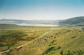
| photo_caption | Mono Basin from near Conway Summit, 2005. |
| location | Mono County, California, United States |
| boundaries | W: Sierra Crest |
| N: Bodie Hills | |
| E: Cowtrack Mountains | |
| S: Long Valley Caldera | |
| coordinates | |
| coordinates_ref | |
| elevation | 6380 ft |
| depth | 6680 ft |
| area | 631 to |
| :: |
| name = Mono Basin | photo = Mono Lake.jpg | photo_caption = Mono Basin from near Conway Summit, 2005. | location = Mono County, California, United States | boundaries = W: Sierra Crest N: Bodie Hills E: Cowtrack Mountains S: Long Valley Caldera | coordinates = |coordinates_ref= | elevation = 6380 ft | depth = 6680 ft | area = 631 to
The Mono Basin is an endorheic drainage basin located east of Yosemite National Park in California and Nevada. It is bordered to the west by the Sierra Nevada, to the east by the Cowtrack Mountains, to the north by the Bodie Hills, and to the south by the north ridge of the Long Valley Caldera.
Estimates of the size of the basin range from 634 to 801 square miles, and the basin's elevation ranges from around 6,380 feet (level of Mono Lake as of 1986) to 13,061 feet atop Mount Dana near the Sierra Crest. | id = HR2738 | designation = Mount Dana}}
Notable features in the basin include Mono Lake and the Mono-Inyo Craters, as well as the town of Lee Vining.
Geology
Geologically the basin is a structural basin that is bordered to the west by the frontal fault of the Sierra Nevada. The basin is part of the Walker Lane, an area where much of the deformation between the North American Plate and the Pacific Plate occurs.
The basin was formed by geological forces over the last five million years: basin and range crustal stretching and associated volcanism and faulting at the base of the Sierra Nevada.
::figure[src="https://upload.wikimedia.org/wikipedia/commons/4/43/Mono_Lake_sat_zoomed.jpg" caption="Image of Mono Lake from space, 1985"] ::
From 4.5 to 2.6 million years ago, large volumes of basalt were extruded around what is now Cowtrack Mountain (east and south of Mono Basin); eventually covering 300 sqmi and reaching a maximum thickness of 600 ft. Later volcanism in the area occurred 3.8 million to 250,000 years ago. This activity was northwest of Mono Basin and included the formation of Aurora Crater, Beauty Peak, Cedar Hill (later an island in the highest stands of Mono Lake), and Mount Hicks.
Lake Russell was the prehistoric predecessor to Mono Lake, during the Pleistocene. Its shoreline reached the modern-day elevation of 2280 m, about 330 m higher than the present-day lake. As of 1.6 million years ago, Lake Russell discharged to the northeast, into the Walker River drainage. After the Long Valley Caldera eruption 760,000 years ago, Lake Russell discharged into Adobe Lake to the southeast, then into the Owens River, and eventually into Lake Manly in Death Valley. Prominent shore lines of Lake Russell, called strandlines by geologists, can be seen west of Mono Lake.
Mono Basin is currently geologically active. Volcanic activity is related to the Mono-Inyo Craters: the most recent eruption occurred 350 years ago, resulting in the formation of Paoha Island. Panum Crater is an example of a combined rhyolite dome and cinder cone.
Footnotes
References
References
- {{cite gnis
- Mono Basin Ecosystem Study Committee, [[United States National Research Council. (1987). "The Mono Basin ecosystem : effects of changing lake level". National Academy Press.
- Schweich, Tom. "Overview Map of Mono Basin". Eastern Mojave Vegetation.
- [http://www.schweich.com/geoCAMnoMonoBasin.html Mono Basin, Mono County, California]
- Mono Basin Ecosystem Study Committee, [[United States National Research Council. (1987). "The Mono Basin ecosystem : effects of changing lake level". National Academy Press.
- (May 1993). "Mono Basin EIR".
- Jayko, Angela. "Geology of Federal Lands in the Eastern Sierra Region, southwestern Great Basin". USGS.
- Tierney, Timothy. (2000). "Geology of the Mono Basin". Kutsavi Press, Mono Lake Committee.
- (2002). "Drainage reversals in Mono Basin during the late Pliocene and Pleistocene". Geological Society of America Bulletin.
- "Mono Lake". USGS.
- "Mono-Inyo Craters". USGS.
- "Long Valley Caldera Field Guide - Panum Crater". USGS.
::callout[type=info title="Wikipedia Source"] This article was imported from Wikipedia and is available under the Creative Commons Attribution-ShareAlike 4.0 License. Content has been adapted to SurfDoc format. Original contributors can be found on the article history page. ::