Mangoro River
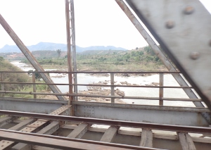
River in Eastern Madagascar
title: "Mangoro River" type: doc version: 1 created: 2026-02-28 author: "Wikipedia contributors" status: active scope: public tags: ["rivers-of-madagascar", "atsinanana", "rivers-of-analamanga", "rivers-of-atsinanana"] description: "River in Eastern Madagascar" topic_path: "general/rivers-of-madagascar" source: "https://en.wikipedia.org/wiki/Mangoro_River" license: "CC BY-SA 4.0" wikipedia_page_id: 0 wikipedia_revision_id: 0
::summary River in Eastern Madagascar ::
::data[format=table title="Infobox river"]
| Field | Value |
|---|---|
| name | Mangoro River |
| name_native | mg |
| image | Mangoro.jpg |
| image_caption | Mangoro |
| map | Rijeka mangoro.png |
| map_caption | Mangoro River |
| subdivision_type1 | Country |
| subdivision_name1 | Madagascar |
| length | 300 km |
| discharge1_location | Near mouth |
| discharge1_avg | (Period: 1971–2000)386.3 m3/s |
| source1_location | 14 km from Mandialaza, NE of Anjozorobe |
| source1_elevation | 1,100 m |
| mouth_location | Ambodiharina, Indian Ocean |
| mouth_coordinates | |
| mouth_elevation | 0 m |
| river_system | Mangoro River |
| basin_size | 17,175 km2 |
| tributaries_right | Onive, Nosivolo |
| :: |
| name = Mangoro River | name_native = mg | name_native_lang = | name_other = | name_etymology = | image = Mangoro.jpg | image_size = | image_caption = Mangoro | map = Rijeka mangoro.png | map_size = | map_caption = Mangoro River | pushpin_map = | pushpin_map_size = | pushpin_map_caption= | subdivision_type1 = Country | subdivision_name1 = Madagascar | subdivision_type2 = | subdivision_name2 = | subdivision_type3 = | subdivision_name3 = | subdivision_type4 = | subdivision_name4 = | subdivision_type5 = | subdivision_name5 = | length = 300 km | width_min = | width_avg = | width_max = | depth_min = | depth_avg = | depth_max = | discharge1_location= Near mouth | discharge1_min = | discharge1_avg = (Period: 1971–2000)386.3 m3/s | discharge1_max = | source1 = | source1_location = 14 km from Mandialaza, NE of Anjozorobe | source1_coordinates= | source1_elevation = 1,100 m | mouth = | mouth_location = Ambodiharina, Indian Ocean | mouth_coordinates = | mouth_elevation = 0 m | progression = | river_system = Mangoro River | basin_size = 17,175 km2 | tributaries_left = | tributaries_right = Onive, Nosivolo | custom_label = | custom_data = | extra = ::figure[src="https://upload.wikimedia.org/wikipedia/commons/c/c7/Carte_bassin_Mangoro.svg" caption="bassin of the Mangoro"] ::
The Mangoro River is the largest river on the east coast of Madagascar by basin size and water volume, and is 300 km in length.
Overview
The Mangoro begins northeast of the town of Anjozorobe in the Analamanga region, at approximately 1,100 meters. Its primary tributaries are the Onive River (which joins on the right bank at 200 km from the river source) and Nosivolo River. Its mouth is at the Indian Ocean near the town of Ambodiharina.
Owing to its many tributaries, the Mangoro maintains a high flow year round, making it an ideal river for rafting.
As of 2012, the Sherritt International Corporation planned to use the Mangoro River as a source of water for a slurry pipeline carrying ore for the Ambatovy project mines, raising environmental concerns.
Wildlife
There are small populations of crocodiles in the more placid sections of the river, but their population is minimal and continues to plummet.
References
::figure[src="https://upload.wikimedia.org/wikipedia/commons/9/98/Madagascar_rivers.svg" caption="Rivers of Madagascar"] ::
References
- "Madagascar".
- "Mangoro River (Madagascar)". LC Linked Data Service (Library of Congress).
- (2010-11-25). "MADAGASCAR: New Livelihoods to Protect A River's Life". Global Issues, Inter Press Service.
- Brill]] 2012) (citing Aldegheri, Marius. ''The Rivers and Streams on Madagascar'', in Battistini, Rene & G. Richard-Vindard (ed.), ''Biogeography and Ecology in Madagascar'' (1972))
- "Mangoro river".
- (2012-04-10). "Another Mining Horror Story? Sherritt International Corporation's Ambatovy Project in Madagascar". [[MiningWatch Canada]].
::callout[type=info title="Wikipedia Source"] This article was imported from Wikipedia and is available under the Creative Commons Attribution-ShareAlike 4.0 License. Content has been adapted to SurfDoc format. Original contributors can be found on the article history page. ::