Kunzum Pass
Mountain pass in the Indian Himalayas
title: "Kunzum Pass" type: doc version: 1 created: 2026-02-28 author: "Wikipedia contributors" status: active scope: public tags: ["mountain-passes-of-himachal-pradesh", "geography-of-kullu-district", "geography-of-lahaul-and-spiti-district"] description: "Mountain pass in the Indian Himalayas" topic_path: "geography" source: "https://en.wikipedia.org/wiki/Kunzum_Pass" license: "CC BY-SA 4.0" wikipedia_page_id: 0 wikipedia_revision_id: 0
::summary Mountain pass in the Indian Himalayas ::
::data[format=table title="Infobox mountain pass"]
| Field | Value |
|---|---|
| name | Kunzum La |
| elevation_m | 4551 |
| traversed | Kaza-Keylong |
| location | Himachal, India |
| photo | File:Kunzum Pass between Lahaul & Spiti 28-6-04.jpg |
| photo_caption | Kunzum Pass between Lahaul & Spiti |
| range | Kunzum, Himalayas |
| coordinates | |
| :: |
| name = Kunzum La | elevation_m = 4551 | elevation_ref = | traversed = Kaza-Keylong | location = Himachal, India | photo = File:Kunzum Pass between Lahaul & Spiti 28-6-04.jpg | photo_caption = Kunzum Pass between Lahaul & Spiti | range = Kunzum, Himalayas | coordinates = | coordinates_ref = | map =
::figure[src="https://upload.wikimedia.org/wikipedia/commons/2/29/Losar-Kunzum_Road_Jun18_D72_7836.jpg" caption="Road from Losar on the Spiti side up to Kunzum La Pass. Mountains on the Lahaul side of the Kunzum Pass." alt=""] ::
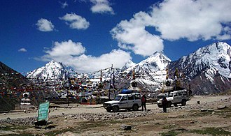
Kunzum Pass (Tibetan: Kunzum La, elev. 4551 m), is a high mountain pass in the eastern Kunzum Range of the Himalayas. It connects Lahaul valley and Spiti valley. It is on the route from Gramphoo in Lahaul to Kaza the subdivisional headquarters of Spiti. Kunzum Pass on NH505 is 122 km from Manali, and 79 km from Kaza.
Transport
NH505 over the Kunzum Pass connects Kaza to Manali in the southwest, and Kaurik, Sumdo, Pooh, & Tabo in east. Kaza-Pooh-Tabo-Shimla route is open the whole year, but the Manali-Kaza route is closed for 7 winter months every year, during which Kunzum Pass (15,000 ft) is closed. NHAI is planning to construct a tunnel under the Kunzum Pass to provide all-weather connectivity between Manali and the Spiti valley. The Kunzum Pass is normally open from June/July to October/November. The dates of opening and closing are dependent on the weather and road repair by the Border Roads Organisation.
NH505 from the Manali-Gramphoo side in the west climbs steeply through fifteen (15) sharp hairpin turns from Batal (el. 4000 m) on the Chandra River, testing the driving skills of even experienced drivers. On the Kaza side in east, the road from the small town of Losar (el. 4076 m) runs on the right bank of a tributary of the Spiti. It climbs through a dry, semi-desert landscape 22 km up to the Kunzum Pass.
Tourism
Many drivers and travelers seek blessings of Kunzum Mata before continuing on the dangerous journey. There is also a 15 km trek to Chandratal, the Moon Lake, from the Kunzum La.
Climate
| location = Kunzum Pass, elevation 4551 m, (1991–2020, extremes 1962–2020) | metric first = Y | single line = Y |Jan high C = -26 |Feb high C = -28 |Mar high C = -19 |Apr high C = -10 |May high C = -7 |Jun high C = 2 |Jul high C = 4 |Aug high C = 7 |Sep high C = 8 |Oct high C = 1 |Nov high C = -12 |Dec high C = -20 | year high C = |Jan low C = -40 |Feb low C = -41 |Mar low C = -36 |Apr low C = -28 |May low C = -20 |Jun low C = -12 |Jul low C = -10 |Aug low C = -9 |Sep low C = -8 |Oct low C = -14 |Nov low C = -30 |Dec low C = -38 | year low C = | rain colour = green | Jan rain mm = 19 | Feb rain mm = 22 | Mar rain mm = 24 | Apr rain mm = 30 | May rain mm = 10 | Jun rain mm = 7 | Jul rain mm = 3 | Aug rain mm = 9 | Sep rain mm = 7 | Oct rain mm = 4 | Nov rain mm = 2 | Dec rain mm = 12 | year rain mm = |time day = 17:30 IST
|source 1 = India Meteorological Department | archive-url = https://web.archive.org/web/20240408025145/https://www.imdpune.gov.in/library/public/Climatological%20Tables%201991-2020.pdf | archive-date = 8 April 2024 | url = https://www.imdpune.gov.in/library/public/Climatological%20Tables%201991-2020.pdf | title = Station: Banihal Climatological Table 1991–2020 | work = Climatological Normals 1991–2020 | publisher = India Meteorological Department | access-date = 17 July 2024}} | archive-url = https://web.archive.org/web/20200205040301/http://imdpune.gov.in/library/public/1981-2010%20CLIM%20NORMALS%20%28STATWISE%29.pdf | archive-date = 5 February 2020 | url = https://imdpune.gov.in/library/public/1981-2010%20CLIM%20NORMALS%20%28STATWISE%29.pdf | title = Station: Banihal Climatological Table 1981–2010 | work = Climatological Normals 1981–2010 | publisher = India Meteorological Department | date = January 2015 | pages = 85–86 | access-date = 15 March 2020}} | source =
Gallery
::figure[src="https://upload.wikimedia.org/wikipedia/commons/a/a4/Kunzom_pass_temple.jpg" caption="Kunzom Shrine]]"] ::
File:Young Tibetan couple at Kunzum Pass.jpg|Young Tibetan couple at Kunzum Pass File:Kunzum Pass between Lahaul & Spiti.jpg|Kunzum Mata temple File:KunzumMilestone.JPG|Kunzum La, Lahaul & Spiti Himachal Pradesh File:Mountain peaks as seen from Kunzum Pass between Lahaul and Spiti.jpg|Mountain peaks as seen from Kunzum Pass between Lahaul and Spiti
References
References
- [https://www.tribuneindia.com/news/himachal/rs-200-cr-for-sumdoh-gramphu-road-99160 Rs 200 cr for Sumdoh-Gramphu road], The Tribune, 14 June 2020.
- "District Lahaul and Spiti > Tourism > How to Reach".
- (17 July 2019). "Kunzum Pass Reopened After Months of Closure".
- "Node: Kunzum La (287412459)".
- Chaudhry, Minakshi. (2007). "Destination Himachal: Over 132 Offbeat and 12 Popular Getaways". Rupa.
::callout[type=info title="Wikipedia Source"] This article was imported from Wikipedia and is available under the Creative Commons Attribution-ShareAlike 4.0 License. Content has been adapted to SurfDoc format. Original contributors can be found on the article history page. ::