Kebili
title: "Kebili" type: doc version: 1 created: 2026-02-28 author: "Wikipedia contributors" status: active scope: public tags: ["populated-places-in-kebili-governorate", "oases-of-tunisia", "communes-of-tunisia"] topic_path: "general/populated-places-in-kebili-governorate" source: "https://en.wikipedia.org/wiki/Kebili" license: "CC BY-SA 4.0" wikipedia_page_id: 0 wikipedia_revision_id: 0
::data[format=table title="Infobox settlement"]
| Field | Value |
|---|---|
| official_name | Kebili |
| native_name | ڨبلي |
| image_skyline | Tn-kebili2.jpg |
| imagesize | 250px |
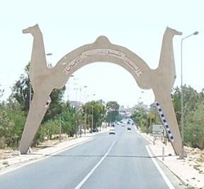
| image_caption | Entrance of the Kebili town |
| pushpin_map | Tunisia |
| pushpin_label_position | bottom |
| subdivision_type | Country |
| subdivision_name | |
| subdivision_type1 | Governorate |
| subdivision_name1 | Kebili Governorate |
| subdivision_type2 | Delegation(s) |
| subdivision_name2 | Kebili North, Kebili South |
| leader_title1 | Mayor |
| leader_name1 | Ahmed Yacoub (Ennahda) |
| established_title2 | |
| established_title3 | |
| population_as_of | 2014 |
| population_total | 28,081 |
| timezone | CET |
| utc_offset | +1 |
| timezone_DST | CEST |
| utc_offset_DST | +2 |
| coordinates | |
| :: |
|official_name = Kebili
|native_name = ڨبلي
|nickname =
|motto =
|image_skyline = Tn-kebili2.jpg
|imagesize = 250px
|image_caption = Entrance of the Kebili town
|image_flag =
|image_seal =
|image_map =
|mapsize =
|map_caption =
|pushpin_map = Tunisia
|pushpin_label_position = bottom
|pushpin_map_caption =
|pushpin_mapsize =
|subdivision_type = Country
|subdivision_name =
|subdivision_type1 = Governorate
|subdivision_name1 = Kebili Governorate
|subdivision_type2 = Delegation(s)
|subdivision_name2 = Kebili North, Kebili South
|leader_title1 = Mayor
|leader_name1 = Ahmed Yacoub (Ennahda)
|leader_title2 =
|leader_name2 =
|leader_title3 =
|leader_name3 =
|established_title =
|established_date =
|established_title2 =
|established_date2 =
|established_title3 =
|established_date3 =
|area_magnitude =
|area_total =
|TotalArea_sq_mi =
|area_land =
|LandArea_sq_mi =
|area_water =
|WaterArea_sq_mi =
|area_water_percent =
|area_urban =
|UrbanArea_sq_mi =
|area_metro =
|MetroArea_sq_mi =
|population_as_of = 2014
|population_note =
|population_total = 28,081
|population_density =
|population_density_mi2 =
|population_metro =
|population_density_metro_km2 =
|population_density_metro_mi2 =
|population_urban =
|timezone = CET
|utc_offset = +1
|timezone_DST = CEST
|utc_offset_DST = +2
|coordinates =
|elevation =
|elevation_ft =
|postal_code_type =
|postal_code =
|website =
|footnotes =
Kebili (, ) is a town in the south of Tunisia and one of the main cities in the Nefzaoua region. It is located in southern Tunisia near the Chott el Djerid salt lake. It is the capital of the Kebili Governorate.
History
Kebili is one of the oldest oases in Tunisia and North Africa. It holds the earliest hard evidence of human habitation in Tunisia (found near the town) and dates back about 200,000 years. Kebili, along with many other Tunisian cities, became part of the Roman Empire after the Punic Wars.
Demographics
Kebili's population is more diverse compared to other Tunisian governorates. The population traces its roots to three main groups:
- Berbers: The native inhabitants of Tunisia and North Africa.
- Arabs: They came to Kebili in the early days of the Muslim conquest. Most came from the Southern Arabian Peninsula (modern day Saudi Arabia and Yemen). They still hold the tribal names of their ancestors.
- Black Africans: They were brought to the city when it was a slavery trade center. See the Economy section below.
Language and religion
While Arabic is the dominant language in the region, several differences set it apart from the Tunisian Arabic spoken elsewhere in the country. Most notably, the letter qāf ق is pronounced as a rather than the guttural . Additionally, some villages use the feminine plural pronouns antunna أنتن (plural you) and hunna هن (they). These pronouns are very rare throughout the Arab world and are usually replaced by their masculine counterparts antum أنتم and hum هم. Bedouin vocabulary and expressions have declined in usage among the new generations.
Islam is the dominant religion. Kebili, as many other Tunisian towns, holds a great number of Soofiat Maqams (Saleheen).
Economy
The economy of Kebili has seen diverse orientations throughout its history. Kebili was one source of the African slavery trade to satisfy European needs. Slaves were taken to Europe through the port of Gabès. Nowadays, Kebili relies heavily on agriculture and tourism.
Agriculture
::figure[src="https://upload.wikimedia.org/wikipedia/commons/8/89/Kebili-village.JPG" caption="Kebili village."] ::
The main agricultural product in the region are dates or "deglets". Kebili produces a very high quality date, exported all around the world and contributing significantly to the local and national economy.
Tourism
Since national independence, the government of Tunisia has encouraged tourism projects and resorts in the Saharan region. Of these Douz, south of Kebili, is the most famous Saharian destination of Tunisia (known as the Sahara Gate).
Climate
Temperature records have been kept here from 1901–1939, 1949–1953, and 2000–2012. The French colonial authorities of the Service météorologique de Tunis maintained the older records. A portion of the original data logs for this early period is in the NCDC archives and at the POR of 1907 to 1932. Like Azizia, Kebili is subject to the foehn-like wind phenomena known as a Ghibili.
The World Meteorological Organization cites Kebili as having recorded the highest temperature ever recorded in Africa at 55.0 C, which is disputed by some meteorologists mainly because in the post WW2-era no temperature above 48.8 C (24 July 1997) was recorded in the Kebili station and no temperature above 51.3 C (Ouargla, Algeria, 5 July 2018) was recorded in the whole continent of Africa.
|metric first = yes |single line = yes |location = Kebili (1981–2010, extremes 1988–2022) |Jan record high C = 26.5 |Feb record high C = 34.3 |Mar record high C = 38.2 |Apr record high C = 40.1 |May record high C = 45.5 |Jun record high C = 48.1 |Jul record high C = 48.8 |Aug record high C = 48.5 |Sep record high C = 45.8 |Oct record high C = 41.2 |Nov record high C = 35.7 |Dec record high C = 28.9 |year record high C = 48.8 |Jan high C = 17.1 |Feb high C = 19.5 |Mar high C = 23.3 |Apr high C = 26.9 |May high C = 31.8 |Jun high C = 36.3 |Jul high C = 39.2 |Aug high C = 39.2 |Sep high C = 34.9 |Oct high C = 30.0 |Nov high C = 23.0 |Dec high C = 17.9 |year high C = |Jan mean C = 10.5 |Feb mean C = 12.5 |Mar mean C = 16.3 |Apr mean C = 19.9 |May mean C = 24.5 |Jun mean C = 28.6 |Jul mean C = 31.2 |Aug mean C = 31.5 |Sep mean C = 28.0 |Oct mean C = 23.2 |Nov mean C = 16.2 |Dec mean C = 11.3 |year mean C = |Jan low C = 4.6 |Feb low C = 5.9 |Mar low C = 9.8 |Apr low C = 13.4 |May low C = 17.7 |Jun low C = 21.6 |Jul low C = 23.9 |Aug low C = 24.7 |Sep low C = 22.0 |Oct low C = 17.2 |Nov low C = 10.0 |Dec low C = 5.3 |year low C = |Jan record low C = -3.3 |Feb record low C = -4.5 |Mar record low C = -0.9 |Apr record low C = 2.8 |May record low C = 6.1 |Jun record low C = 13.7 |Jul record low C = 16.6 |Aug record low C = 16.2 |Sep record low C = 10.6 |Oct record low C = 5.3 |Nov record low C = -1.6 |Dec record low C = -4.5 |year record low C = -4.5 |precipitation colour = green |Jan precipitation mm = 22.9 |Feb precipitation mm = 4.6 |Mar precipitation mm = 12.9 |Apr precipitation mm = 10.9 |May precipitation mm = 6.6 |Jun precipitation mm = 1.1 |Jul precipitation mm = 0.1 |Aug precipitation mm = 1.9 |Sep precipitation mm = 8.1 |Oct precipitation mm = 8.8 |Nov precipitation mm = 10.1 |Dec precipitation mm = 13.3 |year precipitation mm = |unit precipitation days = 1.0 mm |Jan precipitation days = 3.4 |Feb precipitation days = 1.7 |Mar precipitation days = 2.1 |Apr precipitation days = 1.2 |May precipitation days = 0.9 |Jun precipitation days = 0.2 |Jul precipitation days = 0.0 |Aug precipitation days = 0.4 |Sep precipitation days = 1.7 |Oct precipitation days = 1.2 |Nov precipitation days = 1.5 |Dec precipitation days = 2.0 |year precipitation days = |Jan humidity = 68 |Feb humidity = 61 |Mar humidity = 56 |Apr humidity = 52 |May humidity = 53 |Jun humidity = 48 |Jul humidity = 47 |Aug humidity = 50 |Sep humidity = 51 |Oct humidity = 55 |Nov humidity = 62 |Dec humidity = 68 |year humidity = |Jan sun = 212.9 |Feb sun = 226.4 |Mar sun = 244.5 |Apr sun = 251.0 |May sun = 277.0 |Jun sun = 307.5 |Jul sun = 323.7 |Aug sun = 306.2 |Sep sun = 249.0 |Oct sun = 236.1 |Nov sun = 217.3 |Dec sun = 203.6 |year sun = |source 1 = Institut National de la Météorologie (precipitation days/humidity 1961–1990){{cite web | archive-url = https://web.archive.org/web/20191219211209/http://data.transport.tn/dataset/9e1ed3a1-69f5-4ef9-a05e-daa8126fdb7c/resource/acf0d32e-92b3-4247-9281-1b3a1587d23f/download/normales_1981_2010.txt | archive-date = 19 December 2019 | url = http://data.transport.tn/dataset/9e1ed3a1-69f5-4ef9-a05e-daa8126fdb7c/resource/acf0d32e-92b3-4247-9281-1b3a1587d23f | title = Les normales climatiques en Tunisie entre 1981 2010 | publisher = Ministère du Transport | language = fr | access-date = 3 February 2020}}{{cite web | archive-url = https://web.archive.org/web/20191221032155/http://data.transport.tn/dataset/c8d4b465-056c-41e2-a666-05160d19784e/resource/3d38ac83-8a3c-4207-b327-9684131292b3/download/normales_1961_1990.txt | archive-date = 21 December 2019 | url = http://data.transport.tn/dataset/normales-climatiques-en-tunisie-entre-1961-1990/resource/3d38ac83-8a3c-4207-b327-9684131292b3 | title = Données normales climatiques 1961-1990 | publisher = Ministère du Transport | language = fr | access-date = 3 February 2020}}{{cite web | archive-url = https://web.archive.org/web/20191221032448/http://data.transport.tn/dataset/b19bf5d3-5f47-43a3-befc-80a4f4f1d267/resource/0f4ff280-9f86-4e4f-bc18-29df886c2a30/download/extremes.txt | archive-date = 21 December 2019 | url = http://data.transport.tn/dataset/extremes-climatiques-en-tunisie/resource/0f4ff280-9f86-4e4f-bc18-29df886c2a30 | title = Les extrêmes climatiques en Tunisie | publisher = Ministère du Transport | language = fr | access-date = 3 February 2020}}
Gallery
I love kebili sign.jpg Kebili-Stat.JPG Hôtel de ville de Kébili.jpg Carrer de Kébili.jpg Kebili.jpg Entrée Oasis-Kebili.JPG
Notable people
- Hend Sabry (born 1979), Tunisian actress, lawyer and ambassador to the World Food Programme
References
Notes
References
- Eyewitness, D. K.. (2016-06-01). "DK Eyewitness Tunisia". Dorling Kindersley Limited.
- "World Meteorological Organization's World Weather & Climate Extremes Archive".
- "Africa's Hottest Reliably Measured Temperature on Record: 124.3°F on Thursday in Algeria".
- (17 August 2020). "Death Valley, California, may have recorded the hottest temperature in world history » Yale Climate Connections".
- "Extreme Temperatures Around the World".
- (17 August 2020). "Death Valley, California, may have recorded the hottest temperature in world history » Yale Climate Connections".
- "Période ensoleillée 1981-2010 climatiques en Tunisie". Ministère du Transport.
- . (8 August 2021). ["60764: Kebili (Tunisia)"](https://www.ogimet.com/cgi-bin/gsynres?ind=60764&ano=2021&mes=8&day=9&hora=0&min=0&ndays=30). *[[OGIMET]]*.
- . (27 June 2022). ["60764: Kebili (Tunisia)"](https://www.ogimet.com/cgi-bin/gsynres?ind=60764&ano=2022&mes=6&day=28&hora=18&min=0&ndays=30). *OGIMET*.
- "Réseau des stations météorologiques synoptiques de la Tunisie". Ministère du Transport.
::callout[type=info title="Wikipedia Source"] This article was imported from Wikipedia and is available under the Creative Commons Attribution-ShareAlike 4.0 License. Content has been adapted to SurfDoc format. Original contributors can be found on the article history page. ::