Karesuando
title: "Karesuando" type: doc version: 1 created: 2026-02-28 author: "Wikipedia contributors" status: active scope: public tags: ["populated-places-in-kiruna-municipality", "lapland-(sweden)", "divided-cities", "finland–sweden-border-crossings", "populated-places-in-arctic-sweden"] topic_path: "geography" source: "https://en.wikipedia.org/wiki/Karesuando" license: "CC BY-SA 4.0" wikipedia_page_id: 0 wikipedia_revision_id: 0
::data[format=table title="Infobox settlement"]
| Field | Value |
|---|---|
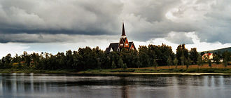
| image_skyline | Karesuando church.jpg |
| image_caption | Karesuando Church in August 2005 |
| pushpin_map | Sweden Norrbotten#Sweden |
| pushpin_label_position | bottom |
| subdivision_type | Country |
| subdivision_name | Sweden |
| subdivision_type3 | Municipality |
| subdivision_name3 | Kiruna Municipality |
| subdivision_type2 | County |
| subdivision_name2 | Norrbotten County |
| subdivision_type1 | Province |
| subdivision_name1 | Lapland |
| area_footnotes | |
| area_total_km2 | 0.93 |
| population_as_of | 31 December 2010 |
| population_footnotes | |
| population_total | 300 |
| population_density_km2 | 324 |
| timezone | CET |
| utc_offset | +1 |
| timezone_DST | CEST |
| utc_offset_DST | +2 |
| coordinates | |
| name | sv |
| pushpin_label | Karesuando |
| other_name | se |
| fi | |
| fit | |
| :: |
| official_name = | image_skyline = Karesuando church.jpg | image_caption = Karesuando Church in August 2005 | pushpin_map = Sweden Norrbotten#Sweden | pushpin_label_position = bottom | subdivision_type = Country | subdivision_name = Sweden | subdivision_type3 = Municipality | subdivision_name3 = Kiruna Municipality | subdivision_type2 = County | subdivision_name2 = Norrbotten County | subdivision_type1 = Province | subdivision_name1 = Lapland | area_footnotes = | area_total_km2 = 0.93 | population_as_of = 31 December 2010 | population_footnotes = | population_total = 300 | population_density_km2 = 324 | timezone = CET | utc_offset = +1 | timezone_DST = CEST | utc_offset_DST = +2 | coordinates = | website = | name = sv | pushpin_label = Karesuando | other_name = se fi fit Karesuando (; or Karesuvanto; Northern Sámi: Gárasavvon; Meänkieli: Karesuanto) is the northernmost locality in Sweden. It is situated in Kiruna Municipality, Norrbotten County, Sweden, with 303 inhabitants in 2010 and 350 in 2011.
It is a church village, located alongside the Muonio River on the border with Finland.
The Finnish village of Karesuvanto (population about 140) is located on the Finnish side of the river. According to Finnish tradition, they are one and the same village (with a combined population of about 470), but are usually considered to be separate villages since there is a national border between them (although both are called Karesuvanto in Finnish).
The village's buildings were built in 1670, when Måns Mårtensson Karesuando, called "Hyvä Maunu Martinpoika" in Finnish and "Good Maunu, Son of Martin" in English, bought land from Sami Henrik Nilsson Nikkas. The first church was built in 1816 because the previous parish church is located on the Finnish side of the border created in 1809. The Lutheran vicar and botanist Lars Levi Laestadius served in Karesuando from 1826 to 1849. It was here that he founded the revivalist movement known to this day as Laestadianism.
The area is traditionally Finnish speaking, and the border was drawn for political reasons in 1809, not because of any cultural or any other border existing at that time. There was not even a parish border, so Karesuando Church was built because the older church was on the Finnish side. School and church influences have since resulted in cultural and linguistic differences.
The area had a training camp for the Norwegian police troops in Sweden during World War II.
Karesuando is located along the European route E45, and is the northern terminus of Swedish national road 99.
Climate
Karesuando has a continental type of a subarctic climate (Köppen Dfc) with short and cool summers and long, cold and sometimes very cold winters. Snowfall varies from year to year, but is often quite moderate due to dry polar air. Still, accumulation in spring is usually quite high since the snow cover does not thaw at all during winter due to the cold averages. The warmest temperature of the month usually goes above freezing in winter, but for very brief spells.
Summers on the other hand, see quite a bit of rainfall. With Karesuando being quite far inland, it is prone both to sizeable warmth for short spells and temperatures either approaching or below -40 C. Despite this cold, however, Karesuando sees some moderation from the North Atlantic Current passing by Scandinavia's western shore near land on those latitudes, which results in winter temperatures being less severe than some climates on latitudes way further south. Due to its high latitude, Karesuando experiences midnight sun and polar night. The UV index in summer is low due to the high latitude. Karesuando itself is below the arctic tree line. The road on the Finnish side of the river however has bushes and marginal taiga north of the Karesuando area. To its south, west and east, boreal forest begin. Higher areas nearby are tundra.
The snow depth is usually modest due to the relative dryness of winters. It was not measured between 2013 and 2018 until the SMHI restored the snow depth station in early 2019.
|location = Karesuando (2002–2020 averages; sunshine for Kiruna 1961–1990; extremes since 1901) |metric first = Yes |single line = Yes |Jan record high C = 7.2 |Feb record high C = 6.4 |Mar record high C = 10.5 |Apr record high C = 15.8 |May record high C = 28.2 |Jun record high C = 32.2 |Jul record high C = 32.5 |Aug record high C = 29.1 |Sep record high C = 24.0 |Oct record high C = 16.0 |Nov record high C = 10.8 |Dec record high C = 6.5 |year record high C = 32.5 |Jan avg record high C = 1.7 |Feb avg record high C = 2.5 |Mar avg record high C = 4.5 |Apr avg record high C = 9.8 |May avg record high C = 20.5 |Jun avg record high C = 24.7 |Jul avg record high C = 25.5 |Aug avg record high C = 24.3 |Sep avg record high C = 18.2 |Oct avg record high C = 9.8 |Nov avg record high C = 3.4 |Dec avg record high C = 2.6 |year avg record high C = 27.1 |Jan high C = -9.7 |Feb high C = -8.2 |Mar high C = -3.0 |Apr high C = 2.9 |May high C = 9.5 |Jun high C = 15.5 |Jul high C = 19.2 |Aug high C = 16.5 |Sep high C = 10.7 |Oct high C = 2.2 |Nov high C = -3.9 |Dec high C = -6.5 |year high C = |Jan mean C = -14.6 |Feb mean C = -13.2 |Mar mean C = -8.3 |Apr mean C = -1.8 |May mean C = 4.8 |Jun mean C = 10.6 |Jul mean C = 14.2 |Aug mean C = 11.7 |Sep mean C = 6.6 |Oct mean C = -1.0 |Nov mean C = -7.8 |Dec mean C = -11.0 |year mean C = |Jan low C = -19.5 |Feb low C = -18.1 |Mar low C = -13.6 |Apr low C = -6.5 |May low C = 0.1 |Jun low C = 5.7 |Jul low C = 9.1 |Aug low C = 6.8 |Sep low C = 2.5 |Oct low C = -4.2 |Nov low C = -11.7 |Dec low C = -15.5 |year low C = |Jan avg record low C = -35.4 |Feb avg record low C = -34.4 |Mar avg record low C = -29.4 |Apr avg record low C = -20.1 |May avg record low C = -7.2 |Jun avg record low C = -0.3 |Jul avg record low C = 2.8 |Aug avg record low C = -0.8 |Sep avg record low C = -5.2 |Oct avg record low C = -16.9 |Nov avg record low C = -26.9 |Dec avg record low C = -30.5 |year avg record low C = -38.0 |Jan record low C = -49.0 |Feb record low C = -48.1 |Mar record low C = -42.8 |Apr record low C = -36.5 |May record low C = -22.0 |Jun record low C = -4.0 |Jul record low C = -1.0 |Aug record low C = -4.6 |Sep record low C = -12.0 |Oct record low C = -28.6 |Nov record low C = -38.0 |Dec record low C = -42.0 |year record low C = -49.0 |precipitation colour = green |Jan precipitation mm = 29.7 |Feb precipitation mm = 23.9 |Mar precipitation mm = 16.5 |Apr precipitation mm = 18.8 |May precipitation mm = 39.4 |Jun precipitation mm = 64.8 |Jul precipitation mm = 82.2 |Aug precipitation mm = 64.2 |Sep precipitation mm = 47.6 |Oct precipitation mm = 33.9 |Nov precipitation mm = 30.9 |Dec precipitation mm = 34.8 |year precipitation mm = |snow colour = green |Jan snow depth cm = 47 |Feb snow depth cm = 61 |Mar snow depth cm = 61 |Apr snow depth cm = 58 |May snow depth cm = 24 |Jun snow depth cm = 0 |Jul snow depth cm = 0 |Aug snow depth cm = 0 |Sep snow depth cm = 1 |Oct snow depth cm = 13 |Nov snow depth cm = 24 |Dec snow depth cm = 41 |year snow depth cm = 65 |Jan sun = 5 |Feb sun = 62 |Mar sun = 139 |Apr sun = 183 |May sun = 232 |Jun sun = 266 |Jul sun = 243 |Aug sun = 159 |Sep sun = 110 |Oct sun = 67 |Nov sun = 18 |Dec sun = 0 |source 1 = |date= October 2014 |source 2=}}
References
References
- (14 December 2011). "Tätorternas landareal, folkmängd och invånare per km2 2005 och 2010". [[Statistics Sweden]].
- (31 December 2011). "Befolkningstabell". Karesuando.
- (1979). "Svenska ortnamn med uttalsuppgifter".
- "Ladda ner meteorologiska observationer för Karesuando". [[SMHI]].
- "Karesuando".
- "SMHI Open Data". [[Swedish Meteorological and Hydrological Institute]].
::callout[type=info title="Wikipedia Source"] This article was imported from Wikipedia and is available under the Creative Commons Attribution-ShareAlike 4.0 License. Content has been adapted to SurfDoc format. Original contributors can be found on the article history page. ::