Funtensee
Lake in Bavaria, Germany
title: "Funtensee" type: doc version: 1 created: 2026-02-28 author: "Wikipedia contributors" status: active scope: public tags: ["lakes-of-bavaria", "berchtesgaden-alps"] description: "Lake in Bavaria, Germany" topic_path: "general/lakes-of-bavaria" source: "https://en.wikipedia.org/wiki/Funtensee" license: "CC BY-SA 4.0" wikipedia_page_id: 0 wikipedia_revision_id: 0
::summary Lake in Bavaria, Germany ::
::data[format=table title="Infobox body of water"]
| Field | Value |
|---|---|
| name | Funtensee |
| image | Funtensee2.jpg |
| location | Berchtesgaden National Park, Bavaria |
| coords | |
| type | Karst lake |
| inflow | Stuhlgraben, Rennergraben |
| outflow | Teufelsmühle (subterrean) |
| catchment | ca. 10 km² |
| basin_countries | Germany |
| length | 233 m |
| width | 152 m |
| area | 3.5 ha |
| depth | 2.50 to |
| max-depth | 5.30 m |
| volume | 100000 m3 |
| shore | 0.78 km |
| elevation | 1601 m |
| pushpin_map | Germany |
| :: |
| name = Funtensee | image = Funtensee2.jpg | caption = | image_bathymetry = | caption_bathymetry = | location = Berchtesgaden National Park, Bavaria | coords = | type =Karst lake | inflow = Stuhlgraben, Rennergraben | outflow = Teufelsmühle (subterrean) | catchment = ca. 10 km² | basin_countries = Germany | length = 233 m | width = 152 m | area = 3.5 ha | depth = 2.50 to | max-depth = 5.30 m | volume = 100000 m3 | residence_time = | shore = 0.78 km | elevation = 1601 m | frozen = | islands = | cities = | reference = | pushpin_map = Germany
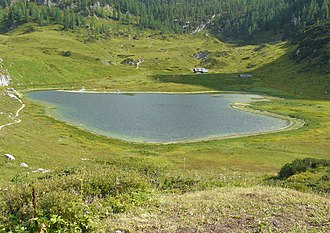
Funtensee is a karst lake on the Steinernes Meer plateau in Berchtesgaden National Park, Bavaria, Germany. It is located in the larger of two sinkholes (also referred to as uvala). The area is known for record low temperatures, up to 30 °C (54 °F) lower than the surrounding area. Its primary inflows are the Steingraben, Stuhlgraben and Rennergraben streams.
Location
::figure[src="https://upload.wikimedia.org/wikipedia/commons/0/0d/Kaerlingerhaus2.jpg" caption="North shore with Kärlingerhaus"] ::
The lake lies at an elevation of 1601 m and has a surface area is 3.5 ha. Its outflow toward the Schrainbach is subterranean at a location called Teufelsmühle. On its shore is the Kärlinger Haus mountain hut which is open for the summer season; in addition, there is a winter room available. The valley is surrounded by the mountains Viehkogel (2,158 m), Glunkerer (1,932 m) and Stuhljoch (2,448 m) which lead to the Funtenseetauern mountain (2,578 m), named after the lake.
History
Earliest evidence of use of the area for grazing can be traced to ca 1604–1619. Around 1870 there was evidence of eight active Kaser (living quarters/stables) causing concerns of overgrazing. The Funtenseealm (hut) was active until 1964.
Temperature
Known as the coldest spot in Germany, the lake is the site where the country's record lowest temperature, −45.9 C,Neuer Temperaturrekord in Deutschland - Tiefste je gemessene Temperatur 24.12.01 shortnews.de was recorded on 24 December 2001. It is theorized that due to the unique situation of trapped cold air, a temperature of -55 C is possible. The extreme cold spot at the lake is said to result in a reverse tree line, as no trees can grow at any point below about 60 m above the lake,
| location = Funtensee | single line = yes | metric first = yes | Jan high C = -2 | Feb high C = -2 | Mar high C = 1 | Apr high C = 6 | May high C = 12 | Jun high C = 15 | Jul high C = 17 | Aug high C = 17 | Sep high C = 13 | Oct high C = 10 | Nov high C = 3 | Dec high C = -1
| Jan low C = -9 | Feb low C = -10 | Mar low C = -7 | Apr low C = -3 | May low C = 2 | Jun low C = 4 | Jul low C = 6 | Aug low C = 7 | Sep low C = 4 | Oct low C = 1 | Nov low C = -4 | Dec low C = -8
| Jan rain mm = 60 | Feb rain mm = 69 | Mar rain mm = 60 | Apr rain mm = 57 | May rain mm = 83 | Jun rain mm = 105 | Jul rain mm = 102 | Aug rain mm = 116 | Sep rain mm = 87 | Oct rain mm = 72 | Nov rain mm = 69 | Dec rain mm = 72
| Jan precipitation days = 11.3 | Feb precipitation days = 12.3 | Mar precipitation days = 12.8 | Apr precipitation days = 12.6 | May precipitation days = 14.8 | Jun precipitation days = 15.4 | Jul precipitation days = 15.5 | Aug precipitation days = 14.5 | Sep precipitation days = 11.9 | Oct precipitation days = 10.8 | Nov precipitation days = 12.3 | Dec precipitation days = 12.5
| Jan snow days = 10.3 | Feb snow days = 11.6 | Mar snow days = 10.6 | Apr snow days = 7.6 | May snow days = 2.7 | Jun snow days = .7 | Jul snow days = .2 | Aug snow days = .1 | Sep snow days = .7 | Oct snow days = 3.3 | Nov snow days = 7.6 | Dec snow days = 11.1
| source = https://www.meteoblue.com/de/wetter/historyclimate/climatemodelled/k%c3%a4rlingerhaus-am-funtensee_deutschland_8379362
Outflow
The noise of the water disappearing underground has led to local folklore and the naming of the outflowpoint Teufelsmühle (Devil's Mill or Devil's Grinder). The exact route the water takes underground has not yet been established, and an extensive cave has not been ruled out, but the outflow point is not accessible to humans for investigation.
References
References
- "FISCHER, K. (1987): Das Funtensee-Uvala im Steinernen Meer".
- [http://www.focus.de/panorama/reportage/reportage-deutschland-extrem_aid_226929.html Deutschland extrem] Focus 2007 no 29
- [http://www.funtensee.de/pdf/fb07-3-pflanzensoziologische-untersuchungen.pdf Pflanzensoziologische Untersuchunges im Bereich der alpinen Baumgrenze um Funtenseegebit unter Berücksichtigung des antopogenen Einflusses] {{Webarchive. link. (2007-10-06 Horst Freiberg 1985)
- [http://www.ad-hoc-news.de/minus-33-4-grad-am-funtensee-in-bayern--/de/Wetter/19965156 Minus 33,4 Grad am Funtensee in Bayern] Adhoc news 21.01.2009
- {{URL. http://www.kaerlingerhaus.de/ [[Deutscher Alpenverein. DAV]] Sektion Berchtesgaden
- [http://www.scinexx.de/dossier-detail-384-9.html Von Teufelslöchern und kollabierenden Salzstöcken Pockennarben auch in Deutschland] 08.02.2008 - scinexx.de
- link. (2009-11-17 '' Berchtesgadener Anzeiger 21.01.2009)
- [http://www.sektion-alpen.net/komp_sagen/teufel_funtensee.htm Die Teufelsmühle am Funtensee] Sektion-alpen.net
::callout[type=info title="Wikipedia Source"] This article was imported from Wikipedia and is available under the Creative Commons Attribution-ShareAlike 4.0 License. Content has been adapted to SurfDoc format. Original contributors can be found on the article history page. ::