Froðba
title: "Froðba" type: doc version: 1 created: 2026-02-28 author: "Wikipedia contributors" status: active scope: public tags: ["populated-places-in-the-faroe-islands", "suðuroy"] topic_path: "general/populated-places-in-the-faroe-islands" source: "https://en.wikipedia.org/wiki/Froðba" license: "CC BY-SA 4.0" wikipedia_page_id: 0 wikipedia_revision_id: 0
::data[format=table title="Infobox settlement"]
| Field | Value |
|---|---|
| name | Froðba |
| settlement_type | Village |
| image_skyline | Froðba (detail).jpg |
| imagesize | 250px |
| image_caption | Froðba |
| pushpin_map | Faroe Islands |
| pushpin_label_position | right |
| pushpin_mapsize | 250 |
| pushpin_map_caption | Location in the Faroe Islands |
| subdivision_type | State |
| subdivision_name | Kingdom of Denmark |
| subdivision_type1 | Country |
| subdivision_name1 | Faroe Islands |
| subdivision_type2 | Island |
| subdivision_name2 | Suðuroy |
| subdivision_type3 | Municipality |
| subdivision_name3 | Tvøroyrar |
| unit_pref | Imperial |
| area_total_km2 | |
| area_land_km2 | |
| population_as_of | September 2025 |
| {{Cite web | title |
| population_total | 255 |
| timezone | GMT |
| timezone_DST | EST |
| utc_offset_DST | +1 |
| coordinates | |
| blank_name | Climate |
| blank_info | Cfc |
| postal_code_type | Postal code |
| postal_code | FO 825 |
| :: |
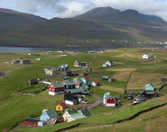
|name = Froðba |settlement_type = Village |image_skyline = Froðba (detail).jpg |imagesize = 250px |image_caption = Froðba |image_map = |mapsize = |map_caption = |pushpin_map = Faroe Islands |pushpin_label_position = right |pushpin_mapsize = 250 |pushpin_map_caption = Location in the Faroe Islands |subdivision_type = State |subdivision_name = Kingdom of Denmark |subdivision_type1 = Country |subdivision_name1 = Faroe Islands |subdivision_type2 = Island |subdivision_name2 = Suðuroy |subdivision_type3 = Municipality |subdivision_name3 = Tvøroyrar |area_magnitude = |unit_pref =Imperial |area_footnotes = |area_total_km2 = |area_land_km2 = |population_as_of = September 2025 |population_footnotes = |population_total = 255 |timezone = GMT |utc_offset = |timezone_DST = EST |utc_offset_DST = +1 |coordinates = |elevation_m = |elevation_ft = |blank_name = Climate |blank_info = Cfc |postal_code_type = Postal code |postal_code =FO 825 Froðba () is a village located furthest out on the north brink of Trongisvágsfjørður, an inlet on the east coast of the island of Suðuroy in the Faroe Islands.
History
The village eventually merged with the harbour city of Tvøroyri. Froðba is usually divided into smaller places such as Hamri, Undir Skorum, Støðlunum, Torvheyggur and Bøur. Bøur is typically referred to as "Úti á Bø" the oldest inhabited area in Froðba, Bøur has a small graveyard which used to be the only one in Trongisvágsfjørður. It is no longer in use and Froðba once had a church which was in Bø, but after Froðba merged with the growing nearby town of Tvøroyri, the small church was moved to Tvøroyri. As the population grew, the church was replaced and moved to Sandvík.
Tradition says that Froðba is the oldest village on Suðuroy and in the Faroe Islands. A legendary Danish king, Frode or Fróði, ran ashore and settled there. The place is named after him. The name Froðba was originally Fróðabæ, in Norse, which means Frode-village or settlement. The name "Fróðabæ" has changed to "Froðabø" and finally "Froðaba" and Froðba; the Faroese word bø translates into place, dwelling, settlement or village in English. The word also has a second meaning, which is field or meadow in English. Note that other villages on Suðuroy share the ending "ba" or "Bæ", "Bø" such as Hvalba and Sumba. The old church in Froðba housed a rune stone which was taken to Denmark in 1823 and cataloged in the Nationalmuseet, but was lost and rediscovered in 2003. Due to some mix up and in cataloguing since its rediscovery, the rune stone's whereabouts are still unknown.
Heliport
There is a heliport near Froðba (at ), the only one with public traffic on Suðuroy. There are helicopter flights to Tórshavn and Vágar Airport.
Gallery
Image:002 Froðba Basaltformationer.JPG|Basalt cliffs Image:Columnar basalt at Froðba, Faroe Islands.jpg|Columnar basalt next to the street Froðbiarvegur Image:003 Froðba grotten Hol í Hellu.jpg|The distinctive cliffs of Hol í Hellu Image:004 Froðba Hól í Hellu.jpg|Hol í Hellu a cave east of Froðba. Image:001 Froðba.JPG|View of Froðba Image:007 Frobiarnipa.JPG|View from Froðbiarnípa to the small islands Lítla Dímun, Stóra Dímun and Skúvoy. Image:Frodba Suduroy Faroeislands March 2010.JPG|View of Froðba from the ferry Smyril Image:Frodbiarnipa Suduroy Faroe Islands View From Smyril.JPG|Froðbiarnípa, view from Smyril File:Atlantic Airways AgustaWestland AW139.jpg|Atlantic Airways AgustaWestland AW139 OY-HIH at Froðba helicopter station.
References
References
- "IB01010 Fólkatalsbroytingar skiftar á fødd, deyð, flutt, bygd og mánaðir (1985-2025)".
- "Timetable".
::callout[type=info title="Wikipedia Source"] This article was imported from Wikipedia and is available under the Creative Commons Attribution-ShareAlike 4.0 License. Content has been adapted to SurfDoc format. Original contributors can be found on the article history page. ::