Dogdyke
Hamlet in the North Kesteven district of Lincolnshire, England
title: "Dogdyke" type: doc version: 1 created: 2026-02-28 author: "Wikipedia contributors" status: active scope: public tags: ["hamlets-in-lincolnshire", "civil-parishes-in-lincolnshire", "north-kesteven-district", "river-witham", "coningsby"] description: "Hamlet in the North Kesteven district of Lincolnshire, England" topic_path: "general/hamlets-in-lincolnshire" source: "https://en.wikipedia.org/wiki/Dogdyke" license: "CC BY-SA 4.0" wikipedia_page_id: 0 wikipedia_revision_id: 0
::summary Hamlet in the North Kesteven district of Lincolnshire, England ::
::data[format=table title="Infobox UK place"]
| Field | Value |
|---|---|
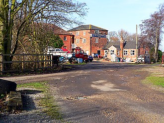
| static_image_name | Dogdyke - geograph.org.uk - 109241.jpg |
| static_image_caption | Dogdyke Marina (former railway station) |
| country | England |
| official_name | Dogdyke |
| coordinates | |
| shire_district | North Kesteven |
| shire_county | Lincolnshire |
| region | East Midlands |
| constituency_westminster | Louth and Horncastle |
| post_town | Lincoln |
| postcode_district | LN4 |
| postcode_area | LN |
| os_grid_reference | TF210554 |
| london_distance_mi | 110 |
| london_direction | S |
| :: |
| static_image_name= Dogdyke - geograph.org.uk - 109241.jpg | static_image_alt= | static_image_caption = Dogdyke Marina (former railway station) | country = England | official_name= Dogdyke | map_alt= | coordinates = | population= | population_ref= | shire_district= North Kesteven | shire_county = Lincolnshire | region= East Midlands | constituency_westminster= Louth and Horncastle | post_town= Lincoln | postcode_district = LN4 | postcode_area= LN | dial_code= | os_grid_reference= TF210554 | london_distance_mi= 110 | london_direction= S NOTOC Dogdyke is a hamlet in the North Kesteven district of Lincolnshire, England. It is situated approximately 2 mi south from Tattershall, and at the confluence of the Rivers Bain and Witham, and close to where the River Slea joins the Witham.
Community
Dogdyke is part of the civil parish of Dogdyke with Chapel Hill within the district of North Kesteven and is within the ecclesiastical parish of Billinghay. The civil parish also includes nearby Tattershall Bridge, where the A153 crosses the Witham. Nearby settlements are the hamlets of Chapel Hill and Tattershall Bridge, and Hawthorn Hill to which Dogdyke is conjoined.
The Chapel of St Nicholas was located at Dogdyke in the 14th century, and was mentioned in 1342. It has long since vanished and its location has not been found. Dogdyke appears as "Dokedyke" in the 14th century, and fell within the ancient wapentake of Langoe.
The hamlet has two public houses, a caravan park and a marina.
Drainage
The first drainage pump at Dogdyke was built in 1796 and was wind-powered. It was replaced in 1856 by the Dogdyke Pumping Station which was driven by steam, and later by diesel.
Dogdyke falls within the drainage area of the Witham Third District Internal Drainage Board.
Chapel Hill, on the opposite west bank of the Witham, falls within the drainage area of the Witham First District Internal Drainage Board.
History
1975 crash
On 3 March 1975 Phantom XV416 from RAF Coningsby hit the top portion of a house in Tattershall Bridge just before 3pm. The pilots had ejected. It occurred 200 yds from the A153. The pilot was 22 year old Flying Officer Phil Tolman, who was married, and from Bedfordshire. The navigator was 30 year old Flight Lieutenant Dave Trotter, who was married. The aircraft came from 111 Squadron.
References
References
- (3 April 2006). "122: Skegness & Horncastle". OSGB.
- "Dogdyke (inc. Chapel Hill) Parish Council".
- "Parish Cluster Areas".
- "Unlocated medieval chapel of St Nicholas at Dogdyke". Lincolnshire Archives.
- (1914). "Calendar of Close Rolls, Richard II".
- "Dog Dyke Pumping Station, Tattershall". Lincolnshire Archives.
- "Witham Third District IDB".
- "Witham First District IDB".
- [https://asn.flightsafety.org/wikibase/59931 Phantom]
- ''Nottingham Evening Post'' Tuesday 4 March 1975, page 1
- ''Lincolnshire Echo'' Tuesday 4 March 1975, page 1
- ''Grimsby Evening Telegraph'' Tuesday 4 March 1975, page 1
- ''Sleaford Standard'' Friday 7 March 1975, page 14
::callout[type=info title="Wikipedia Source"] This article was imported from Wikipedia and is available under the Creative Commons Attribution-ShareAlike 4.0 License. Content has been adapted to SurfDoc format. Original contributors can be found on the article history page. ::