Dhalbhum
Princely estate in British India
title: "Dhalbhum" type: doc version: 1 created: 2026-02-28 author: "Wikipedia contributors" status: active scope: public tags: ["bankura-district", "paschim-medinipur-district", "east-singhbhum-district"] description: "Princely estate in British India" topic_path: "general/bankura-district" source: "https://en.wikipedia.org/wiki/Dhalbhum" license: "CC BY-SA 4.0" wikipedia_page_id: 0 wikipedia_revision_id: 0
::summary Princely estate in British India ::
::data[format=table title="Infobox former subdivision"]
| Field | Value |
|---|---|
| conventional_long_name | Dhalbhum |
| nation | British India |
| subdivision | Zamindari Estate |
| today | East Singhbhum district of Jharkhand |
| year_start | 15th century |
| date_event1 | 1767 |
| event1 | Beginning of Revenue Settlement negotiation with British |
| date_event2 | 1777 |
| event2 | Revenue Settlement with British |
| date_event3 | 1833 |
| event3 | Merged with Manbhum |
| date_event4 | 1846 |
| event4 | Merged with Singhbhum |
| date_event5 | 1879 |
| event5 | Khatra, Raipur and Simlapal area curved out and merged with Bankura |
| s1 | Republic of India |
| flag_s1 | Flag of India.svg |
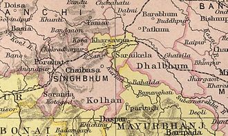
| image_map | Singhbum-Sairakela-Kharsawan.jpg |
| image_map_caption | Dhalbhum as part of extended Singhbhum district in 1909 map of The Imperial Gazetteer of India |
| government_type | Royal rules |
| stat_year1 | 1872 |
| stat_area1 | 3111 |
| stat_pop1 | 117,118 |
| stat_year2 | 1891 |
| stat_area2 | 2970 |
| stat_pop2 | 194,469 |
| stat_year3 | 1941 |
| stat_area3 | 3004 |
| stat_pop3 | 533,402 |
| :: |
::callout[type=note] the medieval historical region ::
|conventional_long_name = Dhalbhum | native_name = | common_name = | nation = British India | subdivision = Zamindari Estate | today = East Singhbhum district of Jharkhand | year_start = 15th century | date_event1 = 1767 | event1 = Beginning of Revenue Settlement negotiation with British | date_event2 = 1777 | event2 = Revenue Settlement with British | date_event3 = 1833 | event3 = Merged with Manbhum | date_event4= 1846 | event4 = Merged with Singhbhum | date_event5 = 1879 | event5 = Khatra, Raipur and Simlapal area curved out and merged with Bankura | year_end = | event_end = |p1 = |s1 =Republic of India |flag_s1 = Flag of India.svg |image_map = Singhbum-Sairakela-Kharsawan.jpg |image_map_caption = Dhalbhum as part of extended Singhbhum district in 1909 map of The Imperial Gazetteer of India | capital = | government_type = Royal rules | status_text = | stat_year1 = 1872 | stat_area1 = 3111 | stat_pop1 = 117,118 | stat_year2 = 1891 | stat_area2 = 2970 | stat_pop2 = 194,469 | stat_year3 = 1941 | stat_area3 = 3004 | stat_pop3 = 533,402
Dhalbhum was an estate in early modern period and British India, spread across the East Singhbhum district in present-day Jharkhand, western part of Bankura, and Midnapore district of West Bengal.
History
Prehistory
Dhalbhum Raj
According to Colonel Dalton and H.H. Risley, the Dhal zamindar family of Dhalbhum was the members of the primitive Bhumij race, who was selected by the other Bhumij chiefs as their feudal ruler. The zamindars later became Hinduised, and adopted the title 'Dhal' or 'Dhabal Deo'. The family is related to the families of Bishnupur, Raipur, Shyamsundarpur and others. A branch of the same family ruled in Chikligarh or Jamboni.
Rankini Devi is established as the family goddess of the Dhalbhum rulers. It is said that human sacrifice was offered to the goddess every year.
Colonial period
::figure[src="https://upload.wikimedia.org/wikipedia/commons/b/bb/Southwest_Bengal,_1776,_by_Rennell.jpg" caption="Dhalbhum under jurisdiction of Medinipur, 1776"] ::
Dhalbhum was part of the Midnapore region of Bengal until 1760 when the East India Company (EIC) acquired Midnapore and Burdwan. Following the cession, the EIC continued revenue surveys and settlements, expanding westward into tribal-concentrated areas where many local chiefs were either of tribal origin or had tribal support. This led to a series of civil and military conflicts, collectively known as the Chuar Rebellion (c. 1760–1833), aimed at resisting British authority. The Tamar Revolt (c. 1783–1793), Kol Uprising (c. 1831–1832), and Bhumij Rebellion or Ganga Narayan Hangama (c. 1832–1833) were part of this larger resistance. To control the unrest, the British created the Jungle Mahal administrative unit in 1805, which was bifurcated into smaller districts in 1833, with Dhalbhum becoming part of Manbhum district. It was merged into Singhbhum district in 1846, while the Porihati area comprising 14.5 sqmi transferred to Jhargram of Midnapore district in 1847 and Khatra, Raipur, and Simlapal areas were transferred to Bankura district in 1879. By 1872, Dhalbhum had a population of across 1,201 square miles. It became part of the Bihar and Orissa Province in 1912 and remained in Bihar Province after 1932. Following India's independence in 1947, Dhalbhum was reorganized as East Singhbhum district in 1990 after being carved out from the extended Singhbhum district.
Demographics
|title=Religion in Dhalbhum (1891) |titlebar=#Fcd116 |left1=Religion |right1=Percent |float=left |bars= According to the Census of 1891, Dhalbhum covered an area of 1,147 sqmi and was inhabited by 194,469 people. Hindus formed 65.34 of the population, while 34.06 followed animistic beliefs; Muslims accounted for 0.55 and Christians for 0.05.
Ethnically, Santals constituted the largest group (29.52), followed by Bhumij (21.74), Tatwa or Tanti (4.62), Kurmi (3.73), Goala (3.31), Munda (3.11), Bagal (2.99), Lohar and Kamar (2.37), Manjhi (2.19), Bhuiya (1.90), Kharia (1.79), Kumhar (1.77), Teli and Kalu (1.37), Brahman (1.32), and Baishnab (1.16). The remaining population comprised smaller communities such as Mahili, Mal, Hajjam or Napit, Dhobi, Dom, Hari and Mihtar, Kalwar and Sunri, Kayastha and Karan, Kharwar, Ghasi, Ho, Gond, Baniya, Rajput, Shaikh, Oraon, Chamar and Muchi, Bagdi, Kewat, and Pan.
References
References
- Ghosh, Binoy, ''Paschim Banger Sanskriti'', (in Bengali), part II, 1978 edition, p. 56, Prakash Bhaban
- O'Malley, L.S.S.. (1908). "Bengal District Gazetteers – Bankura". The Bengal secretariat book depot.
- J, Reid. (1912). "Final Report on the Survey and Settlement of Pargana Dhalbhum in the District of Singhbhum, 1906 to 1911". Bengal Secretariat Book Departmentôt.
- Commissioner, India Census. (1903). "Census of India, 1901: India (4 v.)". Office of the Superintendent of Government Printing, India.
::callout[type=info title="Wikipedia Source"] This article was imported from Wikipedia and is available under the Creative Commons Attribution-ShareAlike 4.0 License. Content has been adapted to SurfDoc format. Original contributors can be found on the article history page. ::