Ayrens
Commune in Auvergne-Rhône-Alpes, France
title: "Ayrens" type: doc version: 1 created: 2026-02-28 author: "Wikipedia contributors" status: active scope: public tags: ["communes-of-cantal"] description: "Commune in Auvergne-Rhône-Alpes, France" topic_path: "general/communes-of-cantal" source: "https://en.wikipedia.org/wiki/Ayrens" license: "CC BY-SA 4.0" wikipedia_page_id: 0 wikipedia_revision_id: 0
::summary Commune in Auvergne-Rhône-Alpes, France ::
::data[format=table title="Infobox French commune"]
| Field | Value |
|---|---|
| name | Ayrens |
| commune status | Commune |
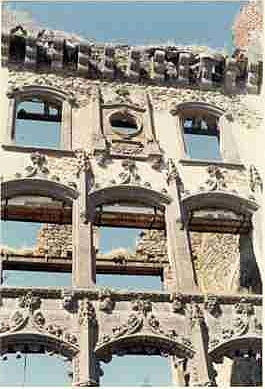
| image | Chateau clavieres-ayrens ruines façade.jpg |
| caption | Ruins of the chateau of Clavières-Ayrens |
| arrondissement | Aurillac |
| canton | Saint-Paul-des-Landes |
| INSEE | 15016 |
| postal code | 15250 |
| mayor | Hubert Bonhommet |
| term | 2020–2026 |
| intercommunality | CA Aurillac Agglomération |
| coordinates | |
| elevation min m | 517 |
| elevation max m | 729 |
| area km2 | 25.5 |
| population | |
| population date | |
| population footnotes | |
| :: |
|name = Ayrens |commune status = Commune |image = Chateau clavieres-ayrens ruines façade.jpg |caption = Ruins of the chateau of Clavières-Ayrens |arrondissement = Aurillac |canton = Saint-Paul-des-Landes |INSEE = 15016 |postal code = 15250 |mayor = Hubert Bonhommet |term = 2020–2026 |intercommunality = CA Aurillac Agglomération |coordinates = |elevation m = |elevation min m = 517 |elevation max m = 729 |area km2 = 25.5 |population = |population date = |population footnotes =
Ayrens is a commune in the Cantal department in the Auvergne-Rhône-Alpes region of south-central France.
Geography
Ayrens is located some 15 km north-west of Aurillac and 5 km north of Saint-Paul-des-Landes. Access to the commune is by road D52 from Teissières-de-Cornet in the south-east which passes through the village and continues west then south to join the D120 north-east of Laroquebrou. The D53 comes from Saint-Paul-des-Landes in the south and also passes through the village before continuing north-east to join the D6 near the border of the commune. The D352 goes north from the village to join the D53 north of the commune. Apart from the village there are the hamlets of:
- Les Baraques
- Le Bos Niac
- Boutonnet
- Cels
- Ciels
- Colin
- La Croix-Longue
- Jammes
- Le Mont
- Renac
- Selves
- Serieys
- Tannuies
- La Tronque
The commune is mainly farmland with extensive forests in the northern part.
The Ruisseau du Meyrou flows from the south-east through the south of the commune forming a small part of the western border before continuing north to join the Eize. The Ruisseau d'Ayrens rises in the east of the commune and flows west through the village to the join the Ruisseau du Meyrou on the western border of the commune. The Ruisseau de Braulle flows from the west of the commune through the centre north of the village to join the Ruisseau du Meyrou on the western border. The Ruisseau de Praniac rises in the north of the commune and forms part of the northern border as it flows west to join the Eize.
Neighbouring communes and villages
|width=auto |Centre = Ayrens |North = Saint-Illide |Northeast = Freix-Anglards |East = Jussac |Southeast = Teissières-de-Cornet |South = Saint-Paul-des-Landes |Southwest = Saint-Gérons |West = Laroquebrou |Northwest = Saint-Santin-Cantalès
History
Ayrens commune lies on the Paris meridian and on the 45th parallel north (). It was therefore the fundamental point for the Bonne projection used in the Carte d'État-Major (General Staff Map) in the 19th century.
Administration
List of Successive Mayors |title=Mayors from the French Revolution to 1935 |titlestyle = background:palegreen; ::data[format=table]
| From | To | Name |
|---|---|---|
| 1790 | 1793 | Louis Linthilac |
| 1793 | 1793 | François Maleprade |
| 1793 | 1795 | Louis Dejour |
| 1795 | 1796 | Guillaume Lafon |
| 1796 | 1798 | René Andrieu |
| 1798 | 1799 | Pierre Lallier |
| 1799 | 1802 | Jean Vabret |
| 1802 | 1802 | Louis Bonhomme |
| 1802 | 1803 | François Maleprade |
| 1803 | 1804 | Antoine Maisonobe |
| 1805 | 1805 | François Capelle |
| 1805 | 1806 | Antoine Maisonobe |
| 1806 | 1808 | Charles Devèze |
| 1808 | 1816 | Antoine Bonhomme |
| 1816 | 1820 | Salvenie de Montal |
| 1820 | 1848 | Antoine de Montal |
| 1848 | 1852 | Durand Lafon |
| 1852 | 1857 | Louis Rengade |
| 1857 | 1863 | Antoine Deconquand |
| 1863 | 1876 | Jean Rengade |
| 1876 | 1888 | Emile Gazard |
| 1888 | 1896 | Amédée Rebeyrols |
| 1896 | 1904 | Antoine Mallet |
| 1904 | 1910 | Jean Léon Reniac |
| 1910 | 1920 | Pierre Vidal |
| 1920 | 1933 | Louis Maisonobe |
| 1933 | 1935 | François Veschambres |
| :: |
;Mayors from 1935
::data[format=table]
| From | To | Name | Party | Position |
|---|---|---|---|---|
| 1935 | 1945 | Pierre Poux | ||
| 1943 | 1947 | François Veschambres | ||
| 1947 | 1958 | Adrien Prunet | ||
| 1958 | 1971 | Albert Moissinac | ||
| 1971 | 2008 | Jean Chanut | ||
| 2008 | 2014 | Robert Wallez | ||
| 2014 | 2020 | Philippe Granier | ||
| :: |
Demography
The inhabitants of the commune are known as Ayrencois or Ayrencoises in French.
| align = none | cols = 2 | percentages = pagr | source = EHESS and INSEE |1793 |1390 |1800 |1240 |1806 |1135 |1821 |1151 |1831 |1191 |1836 |1164 |1841 |1183 |1846 |1140 |1851 |1148 |1856 |1117 |1861 |1001 |1866 |1005 |1872 |990 |1876 |962 |1881 |960 |1886 |965 |1891 |1061 |1896 |912 |1901 |960 |1906 |852 |1911 |838 |1921 |740 |1926 |751 |1931 |702 |1936 |642 |1946 |632 |1954 |569 |1962 |513 |1968 |505 |1975 |444 |1982 |544 |1990 |545 |1999 |494 |2007 |551 |2012 |580 |2017 |652
Sites and monuments
::figure[src="https://upload.wikimedia.org/wikipedia/commons/1/18/Chat_Clavieres-Ayrens_fac_1.jpg" caption="The Chateau of Clavières in 1900"] ::
- The Château de Clavières, built in the Troubadour style, was burnt down on 25 May 1936 and left in ruins.
- The Parc de Clavières is registered as an historical monument.
File:Vitraux 007 Clavières-Ayrens.JPG|Stained glass in the Chateau of Clavières File:Vitraux 012- Château de Clavières-Ayrens (Cantal).JPG|Stained glass in the Chateau of Clavières File:Chateau Clavières-Ayrens statue troubadour 300x523.jpg|Statue of a Troubadour at the Chateau
- The intersection of the Paris meridian and the 45th parallel north is in a field where four trees were planted on the occasion of the celebration of the Méridienne verte (Green Meridian) on 14 July 2000. The trees are arranged in a square whose vertices are directed toward the four cardinal points, which allows the determination of the exact intersection point.
Notable people linked to the commune
- Cardinal Guillaume de La Jugie, restored then lived in the Château of Angouste in the 14th century.
- Félix de la Salle de Rochemaure (1856–1915), French félibrige writer, lived in the Château of Clavières.
- Jean Léon Sanis (Ayrens 1804-?), geographer, professor at the Lycée Louis-le-Grand.
References
References
- (9 August 2021). "Répertoire national des élus: les maires".
- [https://www.google.com/maps/place/Ayrens,+France/@44.9802087,2.3239661,12873m/data=!3m1!1e3!4m2!3m1!1s0x47f8078e57be102d:0xbcac5318a8c14199?hl=en Google Maps]
- fr
- [https://www.habitants.fr/cantal-15 Le nom des habitants du 15 - Cantal], habitants.fr
- {{Cassini-Ehess. 294. Ayrens
- [https://www.insee.fr/fr/statistiques/4515315?geo=COM-15016#ancre-POP_T1 Population en historique depuis 1968], INSEE
- [https://chateauclavieres.over-blog.com/article-482138.html ''' Château de Clavières'''] {{in lang. fr
- Ministry of Culture, Mérimée {{Mérimée. IA15000361. IA15000361 Parc de Clavières {{in lang. fr
- [https://web.archive.org/web/20140808051008/http://www.sceaux.fr/sites/www.sceaux.fr/files/felibree2011-004-jm.pdf ''Félibrée de Sceaux'', Sunday 5 June 2011, intervention by Jacques Mouttet] {{in lang. fr
- Duc de La Salle de Rochemaure, ''Gerbert, Silvestre II'' Paul Émile, Paris, 1914 {{in lang. fr
- Marcellin Boudet, ''Necrology of the Duke of La Salle de Rochemaure'', 1915, in RHA, 60 p. {{in lang. fr
::callout[type=info title="Wikipedia Source"] This article was imported from Wikipedia and is available under the Creative Commons Attribution-ShareAlike 4.0 License. Content has been adapted to SurfDoc format. Original contributors can be found on the article history page. ::