As-Samu

Ancient biblical and modern settlement in Palestine
title: "As-Samu" type: doc version: 1 created: 2026-02-28 author: "Wikipedia contributors" status: active scope: public tags: ["cities-in-the-west-bank", "hebron-governorate", "ancient-jewish-settlements-of-judaea", "13-kohanic-cities", "municipalities-of-palestine"] description: "Ancient biblical and modern settlement in Palestine" topic_path: "geography" source: "https://en.wikipedia.org/wiki/As-Samu" license: "CC BY-SA 4.0" wikipedia_page_id: 0 wikipedia_revision_id: 0
::summary Ancient biblical and modern settlement in Palestine ::
::data[format=table title="Infobox settlement"]
| Field | Value |
|---|---|
| name | As Samu' |
| native_name | السموع |
| translit_lang1 | Arabic |
| translit_lang1_type | Arabic |
| translit_lang1_info | السموع |
| translit_lang1_type1 | Latin |
| translit_lang1_info1 | es Samu' (official) |
| Samua (unofficial) | |
| type | Municipality type B |
| image_skyline | Samu 2007 (cropped).jpg |
| image_caption | As-Samu, 2007 |
| image_blank_emblem | As-Samu logo.png |
| pushpin_map | Palestine |
| pushpin_map_caption | Location of As Samu' within Palestine |
| coordinates | |
| grid_name | Palestine grid |
| grid_position | 156/89 |
| subdivision_type | State |
| subdivision_name | State of Palestine |
| subdivision_type1 | Governorate |
| subdivision_name1 | Hebron |
| established_title | Founded |
| government_footnotes | tags -- |
| government_type | Municipality |
| leader_title | Head of Municipality |
| leader_name | abed ennabe elhawamde |
| unit_pref | dunam |
| area_total_km2 | 13.8 |
| area_total_dunam | 13800 |
| population_footnotes | |
| population_total | 26011 |
| population_as_of | 2017 |
| population_density_km2 | auto |
| blank_name_sec1 | Name meaning |
| blank_info_sec1 | originally Eshtemoa, "Place where prayer is heard" |
| :: |
::callout[type=note] the Palestinian village in the West Bank ::
| name = As Samu' | native_name = السموع | translit_lang1 = Arabic | translit_lang1_type = Arabic | translit_lang1_info = السموع | translit_lang1_type1 = Latin | translit_lang1_info1 = es Samu' (official) Samua (unofficial) | type = Municipality type B | image_skyline = Samu 2007 (cropped).jpg | image_caption = As-Samu, 2007 | image_blank_emblem = As-Samu logo.png | blank_emblem_type = | pushpin_map = Palestine | pushpin_map_caption = Location of As Samu' within Palestine | image_map = | map_caption = | coordinates = | grid_name = Palestine grid | grid_position = 156/89 | subdivision_type = State | subdivision_name = State of Palestine | subdivision_type1 = Governorate | subdivision_name1 = Hebron | established_title = Founded | established_date = | government_footnotes = tags -- | government_type = Municipality | leader_title = Head of Municipality | leader_name = abed ennabe elhawamde | unit_pref = dunam | area_footnotes = | area_total_km2 = 13.8 | area_total_dunam = 13800 | elevation_footnotes = | elevation_m = | elevation_min_m = | elevation_max_m = | population_footnotes = | population_total = 26011 | population_as_of = 2017 | population_note = | population_density_km2 = auto | blank_name_sec1 = Name meaning | blank_info_sec1 = originally Eshtemoa, "Place where prayer is heard" | website = **As Samu'''' or **es-Samu'''' () () is a town in the Hebron Governorate of the West Bank, Palestine, 12 kilometers south of the city of Hebron and 60 kilometers southwest of Jerusalem. The town had a population of 26,011 in 2017.
As-Samu' is located on a tell identified with the ancient Eshtemoa, from which it derives its name. Initially a small village in the early Ottoman era, as-Samu' gradually grew into a larger settlement over the years. In 1966, it was the site of the Samu incident. Since the 1990s, as-Samu' has been governed by the Palestinian Authority as part of Area A of the West Bank. It is known for its handwoven kilims.****
Geography
The area is a hilly, rocky area cut by some wadis. The Armistice Demarcation Line (ADL, Green line) runs generally east to west approximately five kilometers south of as-Samu'. The village of as-Samu' is located on twin hills with a wadi varying from shallow to deep between them. According to the Palestinian Central Bureau of Statistics the town had a population of 19,649 in 2007.
History
Ancient period
Main article: Eshtemoa
As-Samu' is built upon a tell identified with the biblical Eshtemoa mentioned in various historical sources. In 1971, five pottery jars dated to the 9th-8th centuries BCE were found in as-Samu', bearing inscriptions written in the Paleo-Hebrew alphabet. These jars contained one of the largest silver hoards ever found in Palestine.
Classical period
In the 4th-century CE, Eshtemoa was described by Eusebius in his Onomasticon as a large Jewish village.
In the late 19th century, a number of explorers visited the village and documented carved architectural elements scattered within it. These elements were incorporated into the walls of the village houses, with some reportedly adorned with a menorah and Hebrew/Aramaic inscriptions.
A distinctive burial cave from the second and third centuries CE was discovered at as-Samu'. It features an elliptical layout along with collection pits and storage chambers integrated into its walls. Inside, twelve intact Jewish ossuaries dating from Late Second Temple Period to the Late Roman period.
In 1934, the remains of the "Eshtemoa synagogue," were unearthed at as-Samu'. The synagogue is dated to around the 4th–5th century CE. Four seven-branched menorahs were discovered carved onto door lintels and one of them is displayed in Jerusalem's Rockefeller Museum.[[File:Eshtemou_2013.jpg|thumb|[[Eshtemoa synagogue]]/Omari Mosque at as-Samu' and dated to the 4th–5th century CE]]
Middle Ages
After the Muslim conquest, as-Samu' was resettled by Muslims. Under Islamic rule, the synagogue was repurposed as a mosque, which was constructed in its main prayer hall, with the addition of a mihrab. Some sources attribute the repurposing to the 7th century, during the Umayyad period, while Robert Schick suggests it may have taken place later, in the 10th century.
What was earlier identified to be part of a 12th-century Crusaders tower.
Ottoman era
::figure[src="https://upload.wikimedia.org/wikipedia/commons/0/08/Ruins_of_Semua._Coloured_lithograph_by_Louis_Haghe_after_Dav_Wellcome_V0049467.jpg" caption="As-Samu in 1839, from ''[[The Holy Land, Syria, Idumea, Arabia, Egypt, and Nubia]]''."] ::
As-Samu' was incorporated into the Ottoman Empire in 1517. In the 16th century, it was a minor village, predominantly a cave settlement that remained stable over various periods. Its inhabitants routinely made seasonal journeys into the Samirah region.
In the census of 1596 the village appeared as being in the Nahiya of Halil of the Liwa of Quds. It had a population of 16 households, all Muslim. They paid a fixed tax-rate of 33,3% on agricultural products, including wheat, barley, vineyards and fruit trees, in addition to occasional revenues, goats and bee-hives; a total of 3000 akçe.
In 1838, Edward Robinson identified the town of Semua with biblical Eshtemoa. He described As-Samu as a "considerable" village..."full of flocks and herds all in fine order". He also found remains of walls built from very large stones, some of which were more than 10 feet long. In 1863 the French explorer Victor Guérin visited the place.
An Ottoman village list from about 1870 found that as-Samu had a population of 298, in 77 houses, though the population count included men, only.
In 1883, the Palestine Exploration Fund's Survey of Western Palestine described it as "A village of moderate size, standing high. On the north is an open valley, and the modern buildings extend along a spur which runs out west from the watershed. The ground is rocky on the hills, but the valleys are arable land. There are remains of an ancient castle in the village, and other fragments. A church is said once to have existed here, and the ruins to the west show that the town was once much larger. To the south there are olives in the valley. To the north there are rock-cut tombs on the hill-side; the water-supply is from cisterns. The inhabitants number some 400 to 500 souls.
British Mandate era
In the 1922 census of Palestine conducted by the British Mandate authorities, As-Samu (called: Al Samu) had an entirely Muslim population of 1,600 inhabitants. In the 1931 census, As-Samu, together with Khirbat al-Simia and Kh. Rafat had a total of 1,882 Muslims, in 372 houses. In 1934, remains of the towns ancient synagogue were discovered and the site was later excavated in 1969, by Ze'ev Yeivin.
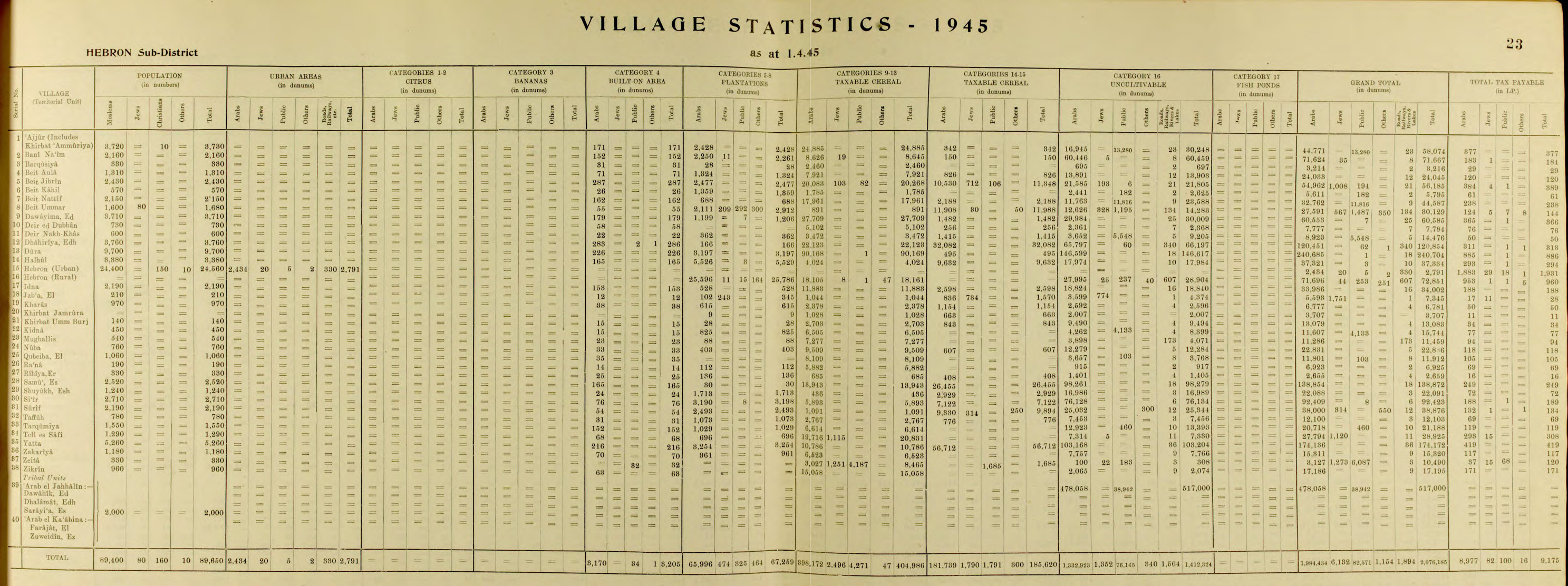
In the 1945 statistics the population of as-Samu' was 2,520, all Muslims, who owned 138,872 dunams of land according to an official land and population survey. 30 dunams were plantations and irrigable land, 40,398 for cereals, while 165 dunams were built-up (urban) land.
Jordanian era
In the wake of the 1948 Arab–Israeli War and the 1949 Armistice Agreements, As-Samu was annexed by Jordan along with the rest of the renamed ‘West Bank’. In 1961, the population of Samu was 3,103.
Samu Incident
Main article: Samu Incident
In 1966 Israel launched a full-scale military operation against the town, which resulted in the deaths of fifteen Jordanian soldiers and three Jordanian civilians; fifty-four other soldiers were wounded. The villagers suffered 3 civilians killed and 96 wounded. According to David Dean Shulman, the villagers were unconnected to the incident that had triggered the reprisal. Much of the village was destroyed. The commander of the Israeli paratroop battalion, Colonel Yoav Shaham, was killed and ten other Israeli soldiers were wounded.
Israeli occupation
As a result of the Six-Day War in 1967, 'as-Samu came under Israeli occupation. The population in the 1967 census conducted by the Israeli authorities was 3,784. Under the Oslo Accords, the town was assigned to Area A.
It was reported in 2005 that 10,000 dunums of land in the towns of 'as-Samu, Yatta and ad-Dhahiriya near Hebron were to be seized by the Israel Defense Forces for the construction of the separation wall. Palestinian sources have alleged that settler violence from the nearby Israeli settlements of Ma'on and Asa'el has prevented them from accessing their fields.
Demography
Among the residents of as-Samu are the Abu Awwad, al-Badareen, ad-Daghameen, al-Hawadah, al-Mahareeq, ar-Rawashdah, al-Salameen and az-Za'areer families.
Culture
A headdress or 'money hat' (wuqayat al-darahem) from as-Samu (c. 1840s, with later additions) is exhibited at the British Museum. The caption notes that the headdress was worn in the 19th century and early 20th century during the wedding ceremony, especially for the 'going out to the well' ceremony when the bride appeared in public as a married woman for the first time. Generally, the headdress was considered to be one of the most important parts of the Palestinian costume.
As-Samu' is also known for its handwoven kilims.
References
Bibliography
- Ben-Yehûdā, Ḥ. and Sandler, Shmuel (2002). The Arab-Israeli Conflict Transformed: Fifty Years of Interstate and Ethnic Crises. SUNY Press.
- Chen, S.: The Design of the Ancient Synagogues in Judaea: Eshtemoa and Horvat Susiya
- (p. 972)
- Hussein of Jordan (1969). My "War" with Israel. London: Peter Owen.
- Oren, M. (2002). Six Days of War. Oxford University Press.
- Prittie, Terence (1969). Eshkol of Israel: The Man and the Nation. London, Museum Press.
- (p. 312)
References
- (February 2018). "Preliminary Results of the Population, Housing and Establishments Census, 2017". [[State of Palestine]].
- [doi.org/10.1093/jts/os-XIII.49.83]
- [http://domino.un.org/UNISPAL.NSF/59c118f065c4465b852572a500625fea/af3bf4fc576922b60525672e0050bea5!OpenDocument UN Doc]{{dead link. (October 2016)
- [http://www.pcbs.gov.ps/Portals/_PCBS/Downloads/book1487.pdf 2007 PCBS Census] {{webarchive. link. (10 December 2010 [[Palestinian Central Bureau of Statistics]]. p.121.)
- Yeivin, Ze'ev. (2004). "The Synagogue at Eshtemoa' in Light of the 1969 Excavations". 'Atiqot / עתיקות.
- Finkelstein, Israel. (2013). "Geographical and Historical Realities behind the Earliest Layer in the David Story". Scandinavian Journal of the Old Testament.
- (1998). "A New Look at the Iron Age Silver Hoard from Eshtemoa". Zeitschrift des Deutschen Palästina-Vereins.
- Yeivin, Z., (1990). The silver hoard from Eshtemoa. '''Atiqot'' 10,43-56 (Hebrew).
- (July 2005). "Archaeological encyclopedia of the Holy Land". Continuum International Publishing Group.
- [[Eusebius]], ''Onomasticon - The Place Names of Divine Scripture'', (ed.) R. Steven Notley & [[Ze'ev Safrai]], Brill: Leiden 2005, p. 84 (§429), note 429 {{ISBN. 0-391-04217-3
- Yeivin, Ze'ev. (2004). "The Synagogue at Eshtemoa' in Light of the 1969 Excavations". 'Atiqot.
- Liebowitz, H. (1981). Jewish Burial Practices in the Roman Period. ''Mankind Quarterly'', ''22''(1)
- (2018). "מנהג ליקוט עצמות (Ossilegium) וקבורתן בגלוסקמות באזור דרומא לאחר ימי הבית השני: נקודת מבט ארכיאולוגית". מחקרי יהודה ושומרון.
- (1967). "Jewish Rock-Cut Tombs in Jerusalem and in the Judean Hill-Country / מערות-קברים יהודיות בירושלים ובהרי יהודה". Eretz-Israel: Archaeological, Historical and Geographical Studies / ארץ-ישראל: מחקרים בידיעת הארץ ועתיקותיה.
- (1939). "The Synagogue of Eshtemoa - Preliminary Report". Journal of the Palestine Oriental Society.
- (July 2005). "Archaeological encyclopedia of the Holy Land". Continuum International Publishing Group.
- Léon Yarden. (1971). "The tree of light: a study of the Menorah, the seven-branched lampstand". East and West Library.
- Ehrlich, Michael. (31 May 2022). "The Islamization of the Holy Land, 634–1800". ARC Humanities Press.
- (2018). "Corpus inscriptionum Iudaeae/Palaestinae: a multi-lingual corpus of the inscriptions from Alexander to Muhammad". [[de Gruyter]].
- Robert Schick, The Christian Communities of Palestine from Byzantine to Islamic Rule: A Historical and Archaeological Study (Studies in Late Antiquity and Early Islam 2), Princeton, NJ: The Darwin Press, 1995
- Conder and Kitchener, 1883, SWP III, pp. [https://archive.org/stream/surveyofwesternp03conduoft#page/412/mode/1up 412]–413
- Pringle, 1997, p. [https://books.google.com/books?id=-_NbE5obqRMC&pg=PA118 118]
- Grossman, D. (1986). "Oscillations in the Rural Settlement of Samaria and Judaea in the Ottoman Period". in '''Shomron studies'''. Dar, S., Safrai, S., (eds). Tel Aviv: Hakibbutz Hameuchad Publishing House. p. 369
- Hütteroth and Abdulfattah, 1977, p. 123
- Robinson and Smith, 1841, vol 2, p. [https://archive.org/stream/biblicalresearc00smitgoog#page/n216/mode/1up 194]
- Robinson and Smith, 1841, vol 2, pp. [https://archive.org/stream/biblicalresearc00smitgoog#page/n648/mode/1up 626]–7
- Guérin, 1869, pp. [https://archive.org/stream/descriptiongogr06gugoog#page/n186/mode/1up 173] –176, [https://archive.org/stream/descriptiongogr06gugoog#page/n209/mode/1up 196]
- Socin, 1879, p. [https://archive.org/stream/zeitschriftdesde01deut#page/154/mode/1up 154]
- Hartmann, 1883, p. [https://archive.org/stream/bub_gb_BZobAQAAIAAJ#page/n950/mode/1up 142], also noted 77 houses
- Conder and Kitchener, 1883, SWP III, p. [https://archive.org/stream/surveyofwesternp03conduoft#page/403/mode/1up 403]
- Barron, 1923, Table V, p. [https://archive.org/stream/PalestineCensus1922/Palestine%20Census%20%281922%29#page/n12/mode/1up 10]
- Mills, 1932, p. [https://archive.org/details/CensusOfPalestine1931.PopulationOfVillagesTownsAndAdministrativeAreas 33]
- link. Snunit.k12.il
- Government of Palestine, Department of Statistics, 1945, p. [http://users.cecs.anu.edu.au/~bdm/yabber/census/VSpages/VS1945_p23.jpg 23] {{Webarchive. link. (2021-11-21)
- Government of Palestine, Department of Statistics. ''Village Statistics, April 1945.'' Quoted in Hadawi, 1970, p. [http://www.palestineremembered.com/download/VillageStatistics/Table%20I/Hebron/Page-050.jpg 50] {{webarchive. link. (4 June 2011)
- Government of Palestine, Department of Statistics. ''Village Statistics, April 1945.'' Quoted in Hadawi, 1970, p. [http://www.palestineremembered.com/download/VillageStatistics/Table%20II/Hebron/Page-094.jpg 94] {{Webarchive. link. (2017-08-23)
- Government of Palestine, Department of Statistics. ''Village Statistics, April 1945.'' Quoted in Hadawi, 1970, p. [http://www.palestineremembered.com/download/VillageStatistics/Table%20III/Hebron/Page-144.jpg 144] {{Webarchive. link. (2016-03-03)
- Government of Jordan, Department of Statistics, 1964, p. [http://users.cecs.anu.edu.au/~bdm/yabber/census/JordanCensusPages/JordanCensus1961-p14.pdf 14] {{Webarchive. link. (2018-09-07)
- [[David Dean Shulman]], 'On Being Unfree:Fences, Roadblocks and the Iron Cage of Palestine,' Manoa Vol,20, No. 2, 2008, pp. 13–32
- Perlmann, Joel. (November 2011 – February 2012). "The 1967 Census of the West Bank and Gaza Strip: A Digitized Version".
- B'Tselem Interactive Map https://www.btselem.org/map {{Webarchive. link. (2021-01-22)
- [http://domino.un.org/UNISPAL.NSF/db942872b9eae454852560f6005a76fb/56cecb65d897395185256fe800625629!OpenDocument UN Doc]{{dead link. (October 2016)
- [http://domino.un.org/unispal.nsf/db942872b9eae454852560f6005a76fb/2c04ae1a24b646f58525700600661080!OpenDocument 14 May:]{{dead link. (October 2016)
- [http://reliefweb.int/rw/rwb.nsf/db900SID/EDIS-7GNQ87?OpenDocument Relief web.] According to Palestinian sources, a 30-year-old Palestinian man from the town of As-Samu' sustained multiple bodily injuries when a group of settlers beat him and dragged him to the nearby settlement outpost of Asael. The settlers then tied him to an electricity pole where the assault continued.
- [http://vprofile.arij.org/hebron/pdfs/As%20Samu'_en.pdf Battir village profile] {{Webarchive. link. (2012-06-08 , ARIJ, p, 7)
- [https://artsandculture.google.com/asset/front/9AGin9-mxU_vWQ?childAssetId=agGSv2aBJfdTFg Money hat]
- [https://www.academia.edu/19185680/Samou_a_Kilims Samou'a Kilims] {{Webarchive. link. (2024-09-13 , by Hamdan Taha)
::callout[type=info title="Wikipedia Source"] This article was imported from Wikipedia and is available under the Creative Commons Attribution-ShareAlike 4.0 License. Content has been adapted to SurfDoc format. Original contributors can be found on the article history page. ::