Alligator Pond
title: "Alligator Pond" type: doc version: 1 created: 2026-02-28 author: "Wikipedia contributors" status: active scope: public tags: ["populated-coastal-places-in-jamaica", "beaches-of-jamaica", "populated-places-in-saint-elizabeth-parish", "populated-places-with-year-of-establishment-missing"] topic_path: "general/populated-coastal-places-in-jamaica" source: "https://en.wikipedia.org/wiki/Alligator_Pond" license: "CC BY-SA 4.0" wikipedia_page_id: 0 wikipedia_revision_id: 0
::data[format=table title="Infobox settlement"]
| Field | Value |
|---|---|
| name | Alligator Pond |
| settlement_type | Fishing village |
| pushpin_map | Jamaica |
| pushpin_label_position | left |
| coordinates | |
| coordinates_footnotes | |
| subdivision_type | Country |
| subdivision_name | Jamaica |
| subdivision_type1 | Parish |
| subdivision_name1 | Manchester |
| elevation_ft | 0 |
| population_footnotes | |
| population_total | 1542 |
| population_as_of | 1991 |
| population_est | 1826 |
| pop_est_as_of | 2010 |
| timezone | EST |
| utc_offset | -5 |
| :: |
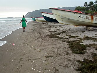
| name = Alligator Pond | settlement_type = Fishing village | pushpin_map = Jamaica | pushpin_label_position = left | coordinates = | coordinates_footnotes = | subdivision_type = Country | subdivision_name = Jamaica | subdivision_type1 = Parish | subdivision_name1 = Manchester | elevation_footnotes = | elevation_ft = 0 | population_footnotes = | population_total = 1542 | population_as_of = 1991 | population_est = 1826 | pop_est_as_of = 2010 | timezone = EST | utc_offset = -5 | footnotes = ::figure[src="https://upload.wikimedia.org/wikipedia/commons/6/67/Alligator_pond_Jamaica_fishing_boats_gm.jpg" caption="Working coast: The beaches are the hub of economic activity in Alligator Pond. The [[bauxite]] exporting Port Kaiser is visible on the horizon."] ::
Alligator Pond is a fishing village on the southwestern coast of Jamaica in the parish of Manchester.
Unlike the tourist-oriented coasts in the northern part of the country, Alligator Pond's shoreline is as much about work as play; here fishermen launch their boats to catch some of the island's best-regarded fish while women conduct the wholesale business of the catch. Weather-worn cookshops and bars line the sand's edge, supplying food staples such as curried goat and Red Stripe beer.
Geography
::figure[src="https://upload.wikimedia.org/wikipedia/commons/3/3e/HillsaboveAlligatorPond.JPG" caption="Hills like alligator's back"] ::
Alligator Pond lies at the foot of the Don Figueroa Mountains to the north-east, some 35 km from Mandeville. The name is said by locals to derive from the shape of the mountain range, which viewed from the beach has bumps which suggest an alligator's back.
The Alligator Pond River is a bathing spot about 3.2 km (2 miles) west of the village off the road leading to Port Kaiser.
The Little Ochie
::figure[src="https://upload.wikimedia.org/wikipedia/commons/5/58/TheLittleOchie.JPG" caption="The Little Ochie restaurant on the beach"] ::
The Little Ochie, a fish restaurant, is located in several huts on the beach, some made from the hulls of fishing boats with thatched roofs. It has expanded to seat several hundred and attracts a clientele from far and wide, including some tourist tours.
References
References
- "Alligator Pond (17°52'16"N 077°34'06"W)". WikiMapia.
- "Alligator Pond, Manchester, Jamaica". World Gazetteer.
- {{GEOnet2. 32FA880170813774E0440003BA962ED3. "Alligator Pond, Manchester, Jamaica" (17°52'N 077°34'W)
- Gerry Manacsa. (22 March 2004). "Days in the Life ... the beach at Alligator Pond, Jamaica".
- Aitkenhead, Decca. (21 January 2006). "Jamaica on a plate". [[The Guardian]].
::callout[type=info title="Wikipedia Source"] This article was imported from Wikipedia and is available under the Creative Commons Attribution-ShareAlike 4.0 License. Content has been adapted to SurfDoc format. Original contributors can be found on the article history page. ::