Aguacatán
title: "Aguacatán" type: doc version: 1 created: 2026-02-28 author: "Wikipedia contributors" status: active scope: public tags: ["municipalities-of-the-huehuetenango-department"] topic_path: "general/municipalities-of-the-huehuetenango-department" source: "https://en.wikipedia.org/wiki/Aguacatán" license: "CC BY-SA 4.0" wikipedia_page_id: 0 wikipedia_revision_id: 0
::data[format=table title="Infobox settlement"]
| Field | Value |
|---|---|
| official_name | Aguacatán |
| native_name | |
| settlement_type | Municipality |
| image_skyline | Guate2004 0417 074028riosanjuan.JPG |
| imagesize | 200px |
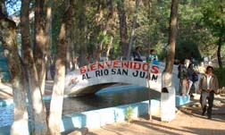
| image_caption | Walkway over Rio San Juan, near the "Nacimiento" |
| dot_x | |
| pushpin_map | Guatemala |
| pushpin_label_position | bottom |
| pushpin_map_caption | Location in Guatemala |
| subdivision_type | Country |
| subdivision_name | [[Image:Flag of Guatemala.svg |
| subdivision_type1 | Department |
| subdivision_name1 | [[Image:Flag of Huehuetenango Department.svg |
| subdivision_type2 | Municipality |
| subdivision_name2 | Aguacatán |
| government_type | Municipal |
| leader_title | Mayor (2012-2020) |
| leader_name | Selvin Omar Villatoro RecinosVacant |
| leader_party | LIDER |
| leader_title1 | |
| established_title | |
| established_title2 | |
| established_title3 | |
| unit_pref | |
| area_total_km2 | 287 |
| area_land_km2 | |
| population_as_of | Census 2018 |
| population_footnotes | |
| population_total | 49607 |
| population_density_km2 | auto |
| population_urban | 8084 |
| population_blank1_title | Ethnicities |
| population_blank1 | Awakatek, Mam, Kʼicheʼ, Chalchitek, Ladino |
| population_blank2_title | Religions |
| population_blank2 | Roman Catholicism, Evangelicalism, Maya |
| coordinates | |
| elevation_footnotes | tags-- |
| elevation_m | 1670 |
| elevation_max_m | 3200 |
| elevation_min_m | 1350 |
| postal_code_type | |
| blank_name | Climate |
| blank_info | Cwb |
| website | http://www.inforpressca.com/aguacatan/ |
| :: |
|official_name = Aguacatán
|other_name =
|native_name =
|nickname =
|settlement_type = Municipality
|motto =
|image_skyline =Guate2004 0417 074028riosanjuan.JPG
|imagesize =200px
|image_caption =Walkway over Rio San Juan, near the "Nacimiento"
|image_flag =
|flag_size =
|image_seal =
|seal_size =
|image_shield =
|shield_size =
|image_blank_emblem =
|blank_emblem_type =
|blank_emblem_size =
|image_map =
|mapsize =
|map_caption =
|image_map1 =
|mapsize1 =
|map_caption1 =
|image_dot_map =
|dot_mapsize =
|dot_map_caption =
|dot_x = |dot_y =
|pushpin_map = Guatemala
|pushpin_label_position =bottom
|pushpin_map_caption =Location in Guatemala
|subdivision_type = Country
|subdivision_name = [[Image:Flag of Guatemala.svg|25px]] Guatemala
|subdivision_type1 = Department
|subdivision_name1 = [[Image:Flag of Huehuetenango Department.svg|25px]] Huehuetenango
|subdivision_type2 = Municipality
|subdivision_name2 = Aguacatán
|subdivision_type3 =
|subdivision_name3 =
|subdivision_type4 =
|subdivision_name4 =
|government_footnotes =
|government_type = Municipal
|leader_title = Mayor (2012-2020)
|leader_name = Selvin Omar Villatoro RecinosVacant
|leader_party = LIDER
|leader_title1 =
|leader_name1 =
|leader_title2 =
|leader_name2 =
|leader_title3 =
|leader_name3 =
|leader_title4 =
|leader_name4 =
|established_title =
|established_date =
|established_title2 =
|established_date2 =
|established_title3 =
|established_date3 =
|area_magnitude =
|unit_pref =
|area_footnotes =
|area_total_km2 = 287
|area_land_km2 =
|area_water_km2 =
|area_total_sq_mi =
|area_land_sq_mi =
|area_water_sq_mi =
|area_water_percent =
|area_urban_km2 =
|area_urban_sq_mi =
|area_metro_km2 =
|area_metro_sq_mi =
|area_blank1_title =
|area_blank1_km2 =
|area_blank1_sq_mi =
|population_as_of = Census 2018
|population_footnotes =
|population_note =
|population_total = 49607
|population_density_km2 = auto
|population_density_sq_mi =
|population_urban = 8084
|population_density_urban_km2 =
|population_density_urban_sq_mi =
|population_blank1_title =Ethnicities
|population_blank1 =Awakatek, Mam, Kʼicheʼ, Chalchitek, Ladino
|population_blank2_title =Religions
|population_blank2 =Roman Catholicism, Evangelicalism, Maya
|population_density_blank1_km2 =
|population_density_blank1_sq_mi =
|timezone =
|utc_offset =
|timezone_DST =
|utc_offset_DST =
|coordinates =
|elevation_footnotes = tags--
|elevation_m = 1670
|elevation_max_m = 3200
|elevation_min_m = 1350
|postal_code_type =
|postal_code =
|area_code =
|blank_name = Climate
|blank_info = Cwb
|blank1_name =
|blank1_info =
|website = http://www.inforpressca.com/aguacatan/
|footnotes =
Aguacatán () is a town and municipality in the Guatemalan department of Huehuetenango. It is situated at 1670 m above sea level. The municipality has a population of 49,607 (2018 census) and covers an area of 287 km2.
Geography
Aguacatán is set in a mountainous area. From the central market, a walk of six blocks will put you in farmland.
Aguacatán was served primarily by dirt roads cutting through the mountains. The dirt road suffered from erosion, potholes and landslides. The paving of the roads to Huehuetenango and Sacapulas and Nebaj was completed in 2006. It now links Aguacatán to the Pan American Highway (near Huehuetenango), and to markets and opportunities for economic growth.
The Nacimiento del Rio San Juan is a natural spring where water pours up out of a small pool. The pool is surrounded by pipes that tap into the water supply. Irrigation from the spring explains the prolific agriculture in the area. The Nacimiento has a park with benches and a two-story observation area.
Demographics
Aguacatán is the only municipality in the world in which Awakateko is the native language. In outlying areas, even just a walk uphill to Aldea San Miguel or up the mountain road to Chex, the native language is Kʼicheʼ. Awakateko is spoken in some other aldeas, including Llano Coyote, near Rio San Juan. Awakateko and Kʼicheʼe' are both Mayan languages. Other languages spoken in the municipality are Mam and Chalchitek. Spanish is also spoken by most residents.
Principal religions are Roman Catholic and Evangelicalism.
Economy
A central market is open most days. Bus service connects Aguacatán to Huehuetenango and other cities. Internet and telephone services are available.
Poor economic conditions have prompted some residents to travel for work to other parts of Guatemala, and also to Mexico and the United States. Some have settled in Tuscarawas County, Ohio.
History
Aguacatán suffered much violence during the Civil War, especially in the early 1980s. The aldea of Chex was attacked, and is now five sub-communities.
In the elections of December 30, 2003, 11 candidates challenged the incumbent mayor. The election results were disputed, a rally of most residents called for a new election, and the mayor closed city offices and operations for months.
Climate
Aguacatán has a subtropical highland climate (Köppen: Cwb).
|width=auto |location = Aguacatán |metric first = yes |single line = yes |Jan mean C = 17.0 |Feb mean C = 17.6 |Mar mean C = 19.3 |Apr mean C = 19.8 |May mean C = 19.9 |Jun mean C = 19.6 |Jul mean C = 19.1 |Aug mean C = 19.0 |Sep mean C = 19.0 |Oct mean C = 18.5 |Nov mean C = 17.9 |Dec mean C = 17.3 |year mean C = |Jan high C = 23.6 |Feb high C = 24.6 |Mar high C = 26.5 |Apr high C = 26.8 |May high C = 26.3 |Jun high C = 25.0 |Jul high C = 24.7 |Aug high C = 25.0 |Sep high C = 24.7 |Oct high C = 24.0 |Nov high C = 24.0 |Dec high C = 23.6 |year high C = |Jan low C = 10.5 |Feb low C = 10.7 |Mar low C = 12.1 |Apr low C = 12.9 |May low C = 13.6 |Jun low C = 14.2 |Jul low C = 13.5 |Aug low C = 13.1 |Sep low C = 13.3 |Oct low C = 13.1 |Nov low C = 11.8 |Dec low C = 11.1 |year low C = |Jan precipitation mm = 35 |Feb precipitation mm = 29 |Mar precipitation mm = 40 |Apr precipitation mm = 63 |May precipitation mm = 147 |Jun precipitation mm = 353 |Jul precipitation mm = 263 |Aug precipitation mm = 225 |Sep precipitation mm = 316 |Oct precipitation mm = 243 |Nov precipitation mm = 98 |Dec precipitation mm = 46 |year precipitation mm = |source 1 = Climate-Data.org |title= Climate: Aguacatán |access-date= 5 October 2015 |website= Climate-Data.org}}
|width=auto |Center=Aguacatán |West = Chiantla, Huehuetenango Department municipality |Southwest = Huehuetenango, Huehuetenango, Huehuetenango Department municipality |South = Huehuetenango, Huehuetenango, Huehuetenango Department municipality |North = Nebaj, Quiché Department municipality |East= Sacapulas, Quiche Department municipality
References
References
- (12 October 2015). "Alcaldes electos en el departamento de Sololá".
- [https://www.citypopulation.de/en/guatemala/admin/ Citypopulation.de] Population of departments and municipalities in Guatemala
- SEGEPLAN. "Municipios del departamento de Huehuetenango".
::callout[type=info title="Wikipedia Source"] This article was imported from Wikipedia and is available under the Creative Commons Attribution-ShareAlike 4.0 License. Content has been adapted to SurfDoc format. Original contributors can be found on the article history page. ::